Category Archives: Events

Wanstead Weather: 2014 review

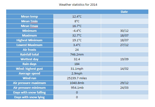
This year finished as the second warmest year on record after 2011.

Every month of 2014, apart from August and December, was warmer than average – the means being over 1C warmer every month, bringing the mean temperature to 12.4C, just 0.4C short of the warmest year in 2011 and 1.2C warmer than the 1981-2010 average.

The number of days with thunder was also high. Thunder has been heard in Wanstead on 19 days. In an average year we can expect thunder on only 12 days.

Rainfall is less remarkable although the year has certainly been wetter than average. The total of 746mm puts it in the top 20 per cent of years for rainfall since 1797.

There was occasional respite from the persistent rain

The year began where 2013 left of: wet. Depressions whistling in off the Atlantic brought incessant rain and the wettest January for 130 years. The total, 131mm, which was 2.5 times the average for January, beat the previous record set in 1988 by just 2.8mm. Unlike 1988, January followed a December that was 1.5 times wetter than average – a wet spell that impacted the river Roding where levels ran high.

The most notable day was probably Saturday 25th when what started as a bright, fine day quickly changed around 4pm as a strong squall with heavy rain blew through with associated thunder and lightning and 6C fall in temperature in an hour.

The warm January was followed by an even warmer February with a complete absence of air frost – very unusual for what is commonly the coldest winter month. The conveyor belt of storms off the Atlantic also calmed though not before a storm on the evening of Valentine’s Day saw yet more damage, resulting in two deaths, including a man killed by a wave on a cruise ship in the Channel and a woman killed when a block of falling masonry crushed her car outside Holborn Tube station. The sheer quantity of rain also brought flooding problems around the area. It was also the first winter ever where no snow falling or lying was observed.

Wanstead Flats by Scott Whitehead
The water table appeared to come to the surface on Wanstead Flats in February

The warmest March for 74 years brought lots of gloriously sunny days, a welcome relief from the run of seemingly endless wet months. Just 25.8mm of rain fell over the 31 days – that’s 63 per cent of average. The most notable weather occurred on the 26th when the temperature fell from 10C at 1.30pm to 4C by 3pm. Heavy showers accompanied what was an utterly foul day. The cold pool persisted into the 27th with towering thunder clouds surrounding Wanstead, north, east and south.

The month ended with warm, sunny weather – the southerly flow bringing Saharan dust that deposited on cars.

April continued this year’s theme of being milder than normal; the mean temperature of 12C was 2.2C above average, making it the third warmest April since 1797.

April continued the dry theme of March. Just 19.6mm on rain fell over the 30 days – that’s 46 per cent of average.

The month saw some stunningly sunny days during the second week into the third week, though these were tempered by chilly east to north-easterly winds. The warmest day was the 21st when 21.5C was reached – the first ^70F temperature of the year.

May was also mild though the rain returned with 71mm falling – 139 per cent of average – this hindered sunshine totals to 157 hours, the dullest for 10 years. Most notable was the number of thunderstorms with four incidents of daily thunder.

This screen grab shows the thunderstorm at 4pm on 24th that saw the temperature fall nearly 6C in a matter of minutes
This screen grab shows the thunderstorm at 4pm on May 24th that saw the temperature fall nearly 6C in a matter of minutes

Though it began unsettled June became warm and dry. Just 15.2mm of rain made it the driest since 2000. The month also brought some spectacular cloudscapes thanks to the high level of thundery activity elsewhere. Though Wanstead did not hear thunder there was plenty of activity close by. It is a typical feature of summer that rainfall can vary a great deal across a small area. The nearest official station to Wanstead, St James’s Park 8.4 miles to our south-west, recorded 33.8mm – more than double what fell here.

June was marked by some spectacular cloudscapes and sunsets. This was the view across Wanstead Flats from Centre Road looking toward Ilford on the 21st

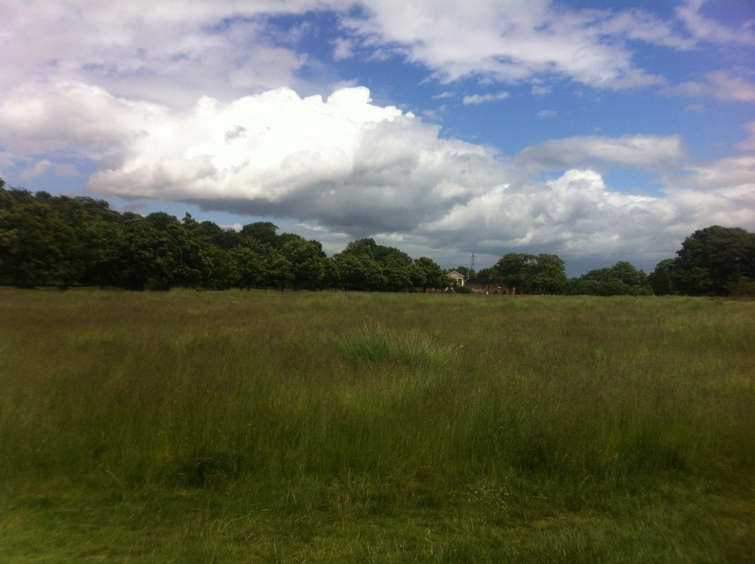
Yet another occasion of impressive cloud formation during June included this example of late evening cirrus. The formation, seen at ground level, seemed similar to a display of the Aurora.

July brought perhaps the most spectacular of our weather. A heatwave brought much thundery activity in what was the 9th warmest July since 1797.

The month was marked with spectacular thunderstorms and torrential downpours, contributing to what was a much wetter than average month – some 73mm fell which is 168% of the monthly average. While on paper the month looks very wet it should be noted that 52% of the July total fell in two episodes: a stalling warm front on the 10th and a cloudburst on 25th. I was away for the thunderstorm though a friend remarked that the roads close to Redbridge Roundabout were like torrents, the rain was so intense for a short period.

The hottest day in July and the year was the 18th with 32.7C recorded. There were 12 occasions where the mercury reached or exceeded 80F.

Perhaps the most impressive thunderstorm was the development of the MCS that moved up from France during the evening of July 18th. There were numerous superb pictures but my favourite is probably this shot taken by Richard Dixon.

This shot was taken by Richard Dixon in Whitstable, Kent. It shows, perfectly, the contrast betweeen the bright orange sunset and the impending doom of the approaching MCS from the continent

What had been a superb summer abruptly ended in August which ended cool, wet and dull. The month, the only one this year that was cooler than average, was characterised by frequent rain and the coldest August night for over 20 years.

More thunderstorms also made it a wetter than average month – some 76mm fell which is 152% of the monthly average and the wettest for 4 years. A couple of nights were notably cool for August: 5C was recorded during the early hours of the 23rd – the coldest August night since 1993.

It was yet another month where rainfall totals could vary greatly in the space of just a few miles. On the 9th a station in Woodford Green recorded 24.4mm, double what fell in Wanstead. The legacy of TS Bertha coincided with the end of our extended hot spell

On 25th a perfect curl could be seen on a depression centred off the west coast of Ireland. The rain associated with this low pressure brought the month’s highest daily rainfall total: 23.4mm (the system bringing 27.5mm) – a thoroughly miserable Bank Holiday Monday where it rained ALL day, from 6am until 9.30pm. It was yet another example of how much even frontal rainfall can vary over a small area with St James Park recording 38.2mm.

sunset overlooking Wanstead Flats 2nd August
Sunset overlooking Wanstead Flats 2nd August

In terms of weather events September was a warm and relatively quiet month save for the two thunderstorms that seemed to mark the Scottish Referendum as the results became apparent in the early hours of Friday 19th. The most notable storm happened around 3pm which brought 24.5mm of rain  with a peak rate of 76.5mm/hr at 15.47. The storm ended a run of 16 dry days. Explosive convection brought hail and rain and flooding to Hackney, Hackney Wick and Leytonstone. This storm was the result of a convergence line over London between light southerlies to the south and easterlies to the north – the heavy rain was very localised.

The month was marked with lots of dry, sunny days, the two thunderstorms on the 19th contributing 89 per cent of the rainfall for the month. It was dryer than average – the 44.8mm that fell is 86 per cent of what we would expect in a normal September. Despite this it was only the driest September here since 2011.

Save for the warmest Hallowe’en on record and a notable depression on the 21st October was a relatively quiet month.

The dry and sunny start was replaced with a very unsettled regime at the end of the first week which lasted until the end of the second week – with 39.5mm of rain falling over the 12th and 13th, a notable total for this region. It was wetter than average: 82.4mm represents 123 per cent of what we’d expect to fall in a normal October. The warmest day occurred on the 31st with 21.5C recorded. Many nights were warm with date records matched or broken. Cold nights, relative to the time of year were few.

The final month of autumn was most notable for its rainfall with 19 consecutive days of measurable precipitation and just four completely dry days .

November 22nd by Perch Pond. Drizzle early morning couple with damp air left mist floating above the surface

November was warmer than average; the mean temperature of 8.9C was 0.9C above average, making it the 19th warmest November since 1797: 2.2C warmer than last November, though only the warmest since 2011.

The sunny and warm start on the 1st was quickly replaced with an unsettled, cooler regime week which lasted for nearly three weeks. A brief respite on the 20th was followed by more rain – with 12mm and 15.2mm on the 22nd and 23rd. It was wetter than average: 97.5mm represents 165 per cent of what we’d expect to fall in a normal November.

Despite it being wet it was only the 40th wettest November in the series back to 1797.

The warmest day occurred on the 1st with 17.2C recorded. The first frosts of autumn were recorded. The lowest temperature occurred on 24th when the mercury fell to -1.5C.

Sunshine was average with 60.5 hours recorded – that’s 103 per cent of mean. The sunniest day was on the 4th when 6 hours of sunshine were recorded.

It was the sunniest December on record in the series going back to 1979. Some 11 mornings were completely clear at the 9am observation time

This December was the sunniest on record in my series going back to 1877. Over 90 hours of sunshine were recorded in this area which is 224% of what we can expect to see during an average December.

Mean temperature for the month was average at 5.8C (0.2C above the 30-year average). Rainfall of 39.9mm was 75% of average – the driest since 2010.

The month was 0.7C cooler than last December – with just under half the rain that fell in that wet and stormy month.

December was warmer than average with a mean temperature of 6.5C (0.9C above the 30-year average) – ranking it 33rd in the series since 1881. Rainfall of 81.9mm was 154% of average – ranking it 22nd in the series.

The month was 1C warmer than last December – with 84% of the rain that fell in December 2012.

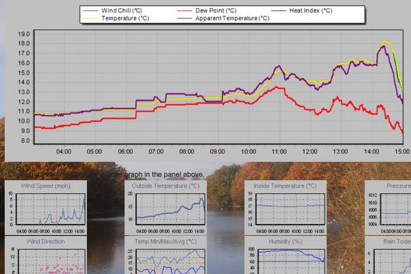
The first day of December was cloudy, dull and dreary with drizzle in a keen east wind. The following days alternated between rain and sun and some night frost. On the 6th the day started sunny with just a few cirrus clouds – overnight frost persisted all day in garden with a grass min at -2C. The 9th began sunny after a hard frost but then the temperature climbed for 19 hours with cloud building and brief rain at 2am before the cold front passed.

Boxing Day was cloudy and cold before rain, with snow in the north, spread in in the evening. A cold front whistled through about 12.40am on the 27th but not before the warm sector raised the temperature to 8.9C

The wettest day occurred on the 11th. The day started sunny but blustery showers blown in on strong WSW winds coupled together with 6 hours of rain overnight produced 11.5mm.
Things turned much milder in the 3rd week with frequent, chiefly light rain, abundant sunshine and an absence of frost. On the 18th the temperature reached 14C.

Christmas Eve saw the weather begin to cool down again with progressively colder nights. Boxing Day was a cloudy, cold day with rain spreading in during the evening and a notable warm sector raising the temperature to nearly 9C at midnight. The first lowland snow of the winter was reported up north. The month ended with long sunny days and sharp frosts, a couple persisting through the day.

To view full stats follow this link:http://1drv.ms/1kiTuzv

weather stats for 2014


The Plymouth tsunami of June 1811

With the 10th anniversary of the Boxing Day Tsunami this year it has often occurred to me whether the British Isles has suffered from a similar catastrophe in centuries gone by.

The 'Extraordinary Phenomenon' reported in the Morning Post, Wednesday, June 5, 1811
The ‘Extraordinary Phenomenon’ reported in the Morning Post, Wednesday, June 5, 1811

With such a vast coastline it is certainly possible but written records of any events seem to be scarce. An entry in Luke Howard’s Climate of London, however, suggests that a phenomenon very similar to what happened in Asia in 2004 happened on our shores.

An entry on May 31, 1811, in Howard’s diary describes an “Agitation of the sea at Plymouth” that began at 3am – the sea fell instantly 4ft and immediately rose 8ft. “Universal consternation” pervaded the whole port, vessels in Catwater were thrown about in the greatest confusion with many dragging their anchor; some drifted and several lost their bowsprits and yards.

At 6.45am the sea rose to the height of 11ft and again receded. At 9.30am the tide suddenly stopped and suddenly ebbed 6 inches. At 10.30am it ebbed again in the same manner and then flowed to high water.

At the time it was noted that two gales from the SSW and E preceded this phenomenon but at the time it happened the wind was light from the SSW.

A few days later, on June 8th, the tide was again seen to flow and ebb several feet in as many minutes which continued at intervals over 4 or 5 hours. Immense swells were seen to flow into the harbours of Sutton Pool and Catwater at a rate of 4 knots an hour. During the time of the boar thunder and lightning was “excessive”.

These events coincided with a volcanic eruption near the shore of Ferraria, São Miguel, creating the short-lived Sabrina Island named after the British frigate HMS Sabrina, whose captain, Commander James Tillard, first identified the island and claimed it for the United Kingdom. The eruption caused destruction to many homes. The islet itself disappeared in the following years.

The event isn’t on record as being a tsunami but the symptoms seen in Plymouth all those years ago are similar, albeit on a much smaller scale, to those seen across Asia in 2004.

Could a tsunami affect the UK in the future? The British Geological Survey says not.


Will it be a white or green Christmas Day?

Over the next couple of weeks speculation on Christmas Day weather will inevitably build. Will Christmas be white or green?

Shoulder of Mutton lake, Wanstead PArk
Shoulder of Mutton pond, Wanstead Park

At this range it is impossible to tell from standard meteorological models though from the 15th, 10 days before the big day and when models can start to be relied upon for at least a general trend, the pieces of the weather jigsaw will start to fall into place.

Latest odds offered by bookies William Hill for a single snowflake at London Heathrow are currently 8-1, slightly longer than I’d expect at this time of year. With high pressure building and a general cooling trend this week I’d expect those odds to start to come down.

In terms of proper snow falling and settling, there has not been a white Christmas in Wanstead for over 30 years. In 2010, we could still see the Christmas card Victorian snow scene in small patches if our gardens, but these were leftovers of a previous dump, so it doesn’t count. Frustratingly, there has been snow on several Boxing Days in Wanstead (1995 and 1996) and in the weeks running up to Christmas, but not on Christmas day itself. The most typical Wanstead Christmas day weather is mild and dry, although it has rained on 12 of the last 33 Christmas days.

Tree damage by the war memorial in Wanstead High Street by Scott Whitehead
The period just before Christmas last year was very stormy

In an earlier blog I had a look at what the last 170 or so Christmas Days in London were like weatherwise and found that snow actually falling on the day is extremely rare. Since 1840 there have been just 19 occasions of snow or sleet falling on the capital on Christmas Day which equates to a probability of just under 11%. If you consider that the last ‘white Christmas’ (see note) was in 1996,  then we are well overdue one.

But the weather doesn’t adhere to human created calendars and behave like it should on any given day. But patterns in any given year can sometimes repeat though correctly predicting they will happen is more down to luck. Nevertheless I’ve had another look at my calculations for this winter and see if there is any way I can make a prediction for Christmas Day.

xmas day 2014I firstly had a look at Christmas Day stats overall since 1840. The most common group of maxima in the series is 8.1C and above. This occurred 69 times or 40%. I then had a look at the years that most closely follow this October and November. None of the years saw a white Christmas, however it is interesting to note that five out of the six years saw some snow during the month. Snow often falls before and after Christmas. Why that is no-one knows.

So my guess for the weather on Christmas Day this year is for a maximum temperature of 6C after an overnight low of around 0C. With a little rain likely I suppose there is a chance of at least something sleety falling though I’d be surprised if, on Christmas Day morning, we pull back the curtains on a wintry Dickensian scene.

* The definition of a white Christmas used most widely – notably by the bookies – is for a single snowflake, even if it lands in the midst of heavy rain, to be observed falling in the 24 hours of 25 December at a specified location recognised by the Met Office.

** On average, snow or sleet falls in the UK 5 days in December, compared with 7.6 days in January, 6.8 days in February and 6 days in March. White Christmases were more frequent in the 18th and 19th centuries, even more so before the change of calendar in 1752, which effectively brought Christmas back by 12 days. Climate change has also brought higher average temperatures over land and sea and this generally reduces the chances of a white Christmas.

Wanstead hero fell victim to bad weather

One hundred years ago this week local newspapers were hailing the bravery of one of its residents who perished in the opening weeks of the Great War.

Claude Gould's obituary notice appeared in the October 30th 1914 edition of the Chelmsford Chronicle Image © Local World Limited. Image created courtesy of THE BRITISH LIBRARY BOARD
Claude Gould’s obituary notice appeared in the October 30th 1914 edition of the Chelmsford Chronicle
Image copyright of Local World Limited. Image created courtesy of  the British Library Board

Claude Gould died after the armored cruiser he was serving on, HMS Hogue, was torpedoed by a German U-boat during a naval engagement in the North Sea known as the Action of September 22nd 1914.  Two other cruisers were sunk, leading to the deaths of approximately 1,450 sailors.  The loss of the three ships remains the biggest maritime disaster in British naval history.

In the October 9th edition of the Essex County Chronicle Mr Gould, of Spratt Hall Road, was described as “a man of exceptionally fine physique, handsome presence, and frank, engaging manners”. The paper points out that he was the eldest son of George ‘Johnstone’ Gould, a “distinguished name in theatrical circles” in the West End and elsewhere.

Claude, who was Chief Yeoman of Signals, had been a member of the Royal Navy for 16 years and since 1912 had been stationed at Chatham, Kent, though he continued to spend most weekends in Wanstead before being mobilised at the beginning of August.

His abilities had been noted during his Naval manoeuvres and he had been recommended for appointment to the battleship Collingwood before he was lent to the Hogue when war broke out.

A survivor of the disaster noted Claude’s final act of bravery. As the ship sunk he was seen destroying his code-book to prevent it falling into the hands of the enemy.

This reanalysis chart shows the depression centred just off Denmark that brought gales in the North Sea, forcing naval destroyers away from escorting cruisers including Hogue
This reanalysis chart shows the depression centred just off Denmark that brought gales in the North Sea, forcing naval destroyers away from escorting cruisers including Hogue. The Air Ministry’s Daily Weather Report for September 17th reports SW’ly severe gale force 9 off Dungeness and Dover – the cause of the heavy seas that forced the destroyers to depart their patrol

Five days before the incident naval destroyers, which had been assigned to protect the cruisers as they patrolled the North Sea, were forced to depart by heavy weather, a blip in a month that overall was dry and bright. Had the weather been different the destroyers would have remained present and the ships would surely have not been such an easy target for the German submarine, the U-9.

The losses from the Action of September 22nd caused a public outcry, eroding confidence in the British government and damaging the reputation of the Royal Navy at a time when many countries were still considering which side in the war they might support.

.

Thunderstorms bring a Holyrood awakening

It was just before 3am that I was awoken by faint rumblings outside. I knew there was a risk of thunder before I’d retired to bed a few hours earlier but I’d discounted the risk along with any thoughts of staying up to watch the referendum results unfold in Scotland.

This radar shot shows the storm just beginning to hit Wanstead. The rain was far heavier to our east. 17.2mm was reported at Laindon, Essex. An observer at Woodford Wells recorded 19.9mm her in about 25 minutes 0310-0335 bst

Lightning then illuminated the room through the gaps in the curtains followed by more rumblings: it’ll pass, I thought. Crash – I grabbed my phone – was this an isolated event? The radar showed a line of slow moving storms moving up from the south. More lightning and loud thunder. My Twitter feed told me it wasn’t going too well for those wanting independence. At this point intensely bright lightning was rapidly followed by one of the loudest claps of thunder I’ve heard around 3.10am. Car alarms were set off – may as well get up I thought… The Inverclyde result was announced – ‘No’, by the narrowest of margins 50.1% to 49.9%. That’s it then, I thought. The lightning and thunder gradually began to fade away with hopes of an independent Scotland, on this night anyway. I glanced at my stats which seemed far less impressive than what was recorded elsewhere: 7.7mm, no big fall in temperature or pressure like previous storms during the summer.

Just a few hours later I walked my younger daughter into school, my bleary eyes struggling to focus – the humid and steamy atmosphere felt more like July than September. Indeed Thursday had been the warmest September 18th since 1997 which, strangely, was the same year that another momentous British event took place: the handover of Hong Kong to China. I remarked to a couple of parents that the only thing that had changed overnight was that Andy Murray will forever be the “Scottish” tennis player after his comment on Twitter.

The forecast advised that there was a continued threat of thunderstorms. It was humid but it didn’t ‘feel’ stormy – though around 2.30pm I could hear the beginning of faint rumblings in the distance.

Clouds above could be seen developing rapidly at 2.30pm

I left for work on my scooter at 3pm, carefully watching the sky for any developments all of which seemed to be in the distance. After stopping for petrol in Leytonstone High Road huge drops of rain began splattering the pavement. They were few and far between, however, and the sun defiantly continued to shine. After riding past Stratford I suddenly became aware that the buildings in the distance, past Bow flyover, were gradually beginning to disappear. I pulled in to a turning where Gala Bingo is situated. An electronic noticeboard enquired: “Do you feel lucky?” Not today I thought and retrieved my overtrousers that live under the seat, hastily pulling them on as I watched the impending storm begin to close in.

I continued on and was soon enveloped in the full force of another thunderstorm. Marble-sized hail clattered off my crash helmet while dangerous gusts, caused by wind funneling through the new high rise flats by the Olympic Park, did their best to push me off. Just as I crossed the canal a sheet of rain engulfed me and the drivers to my right. The road in front suddenly turned into a shallow river. I usually ride over the flyover – not today with the torrent of water cascading off the sides.

The 3.15pm storm that flooded large parts of East London. The white area shows where the heaviest rain was

By the time I reached Mile End the rain had almost stopped. The City looked fairly dry and on reaching London Bridge the roads were completely dry. The Friday crowds were out in force in Borough Market, enjoying the sunshine and seemingly oblivious to the chaos unfolding just a few miles away in East London. Within 10 minutes of walking into my office Alex Salmond announced his resignation. Another storm: another momentous event! It was another of those coincidental storms that, in my mind, seem to mark momentous events such as the Royal birth last July

I checked the stats of the storm back in Wanstead: 24.5mm  fell  with a peak rate of 76.5mm/hr at 15.47. The storm ended a run of 16 dry days bringing the total for the month up to 33mm – the 24hr total was 30.5mm. The explosive convection of this storm can be seen here. The associated hail and rain brought much flooding to Hackney, Hackney Wick and Leytonstone. This storm seemed to be the result of a convergence line over London between light southerlies to the south and easterlies to the north – the heavy rain was very localised.

Flooding images can be seen on the following links at Dalston, Wanstead Flats, Leytonstone Station, Wick Road. A short clip of flooding at Wick Road can be seen here.

The flooding wasn’t restricted to East London. In Southend water started pouring through the roof of the Dixons theatre though it failed to stop the performance. Shops in London Road were inundated.

http://www.echo-news.co.uk/news/11486080.Fire_crews_receive_100_calls_as_severe_flooding_hits_Southend/

See also:

http://www.echo-news.co.uk/news/local_news/11353521.FLOODING_CHAOS___Southend_Hospital_A_E_evacuated_as_south_Essex_is_battered_by_downpour/?ref=var_0

http://www.echo-news.co.uk/news/11486049.Updated__Flash_flooding_hits_homes_and_businesses/?ref=var_0


Overnight storms of July 18th 2014

I’ve decided to cobble together a few lines on last night’s notable thunderstorms which reminded me so much of the stormy nights on the 1980s.

The radar at 3am, produced by the excellent Hone and Dry, revealed that the storm's rainfall was quite widespread. The white areas show the most intense rainfall
The radar at 3am, produced by the excellent Home and Dry, revealed that the storm’s rainfall was quite widespread. The white areas show the most intense rainfall

After writing off the risk of storms for our area last night I was awoken at 3am by loud, rumbling thunder – the kind that seems to resonate all around you. A quick look on the radar revealed quite a widespread thunderstorm, quite different from the smaller, more intense one that woke up most of Wanstead on July 23rd last year.

On viewing the live lightning map at 3.10am it became clear that this was no flash in the pan. Further rumbles and strikes had me leaping out of bed to monitor the station. EssexWeather reported 1809 lightning strikes in two hours for our region.

And on viewing the pressure graph the first storm saw a 6mb fall in pressure in a matter of minutes.

A second storm around 5.30am was less severe though still notable. The 9.4mm that the weather station recorded fell at a rate of 45mm/hr at 3am and 40mm/hr at 5.15am. Though the AWS is often out in heavy rainfall situations on this occasion it was more or less spot on – my 10am reading of my traditional 5″ raingauge revealed the official total to be 9.3mm. The rain took the July  total to 108% of the 1981-2010 mean.

And a squall that blew through just before 4am is well portrayed on this wind graph.

So, all in all, a really lively sticky night where the temperature didn’t fall below 18.2C. I didn’t manage to get any of  my own pictures but this one by @justinstokes on Twitter caught my eye.

According to the CAPE / lifted index further storms seem likely tonight. Indeed the situation across the Channel could be dire. It is probable a few will trundle their way across the sea to give us another sleepless night…
lightning canary wharf

This wind graph shows a gust of 22.8mph at 0336z in my sheltered garden
Radar at 0519 shows another white blob (very heavy rain) about to cross Wanstead


This pressure trace shows the fall in pressure of the two thunderstorms that crossed our region
Live lightning map from http://www.lightningmaps.org/realtime at 3.10am

A dry or wet St Swithun’s?

St Swithun's reputation as a weather saint is said to have arisen from the translation of his body from a lowly grave to its golden shrine within Winchester cathedral, having been delayed by incessant rain for 40 days
St Swithun’s reputation as a weather saint is said to have arisen from the translation of his body from a lowly grave to its golden shrine within Winchester cathedral, having been delayed by incessant rain for 40 days

Legend has it that the weather on Monday will be the same for the next 40 days.

St Swithun’s day, if thou dost rain,
For forty days it will remain;
St Swithun’s day, if thou be fair,
For forty days ’twill rain na mair.

St Swithun’s Day is probably among the most well known of weather folklore – but, taken at face value, it is probably the most unreliable.

Since 1961 Wanstead has enjoyed 30 dry St Swithun’s Days (57%). From these the longest dry spell that followed was just 18 days, in 2000. On average, if St Swithun’s is dry, the weather stays fair for five days, with rain arriving on the 20th.

Another interesting observation is that the 40-day period that followed a dry St Swithun’s is on average 13% WETTER than if it rained on July 15th.

So what does this mean for the rest of July and the summer? Looking back at other years that have seen a mostly dry and warm pattern in the run up to St Swithun’s Day we should see a continuation of the mostly dry, warm and sunny conditions, perhaps with frequent thundery breakdowns, the first arriving on Thursday into Friday.

Putting superstition and singularities aside current weather models back this up.

Featured Image -- 1745St Swithun was born around 800AD and died on July 2, 862, at Winchester, Hampshire. According to historians he was fond of building churches in places where there were none. St Swithun, who was bishop of Winchester, was buried in the churchyard of the Old Minster at Winchester, where passers by might tread on his grave and where the rain from the eaves might fall on it.

His reputation as a weather saint is said to have arisen from the translation of his body from this lowly grave to its golden shrine within the cathedral, having been delayed by incessant rain for 40 days.

The basis of the St Swithun’s saying follows the fact that by July 15th summer weather patterns are already well established and tend to persist through the coming weeks.

In meterological terms the position of the frontal zone around the end of June to early July, indicated by the position of the jet stream, determines the general weather patterns (hot, cold, dry, wet) for the rest of the summer. Like a little stream in its bed, the frontal zone tends to ‘dig in’ shortly after the summer solstice.

As the path of our weather systems is controlled by the jet stream, a more southerly location of the frontal zone – as happened last year – is likely to bring unsettled, wet and cool weather. On the other hand, a frontal zone shifted further to the north – as is happening this year – will help the Azores high to build over western Europe, thus bringing dry and pleasant weather to the UK.

Other western European countries also have similar St Swithun’s day sayings – that follow the principle rule. In France they say ‘Quand il pleut a la Saint Gervais Il pleut quarante jours apres’ – If it rains on St. Gervais’ day (July 19th), it will rain for fourty days afterward.
In Germany the Siebenschlaefer or seven sleepers day (July 7th, after the Gregorian calendar) refers to the weather patterns of the following seven weeks.

June deluge that created Redbridge-on-Sea

It was the summer when the ‘sea’ came to Redbridge.  A record-breaking 59-hour deluge in the middle of June 1903 left vast swaths of the borough inundated. But this was no thundery downpour. All across London and the South East record rainfall rates and totals were set, many of which still stand well over a century later.

The writer of this postcard wrote the following: "Just sending you a few postcards to let you see what a plight we have been in Ilford. This view is the River Roding from the bridge. This was a large green field now it is like a large river but glad to say it has subsided a little of course. You will have read it in the papers I have sent you."
The author of this postcard wrote the following:
“Just sending you a few postcards to let you see what a plight we have been in Ilford. This view is the River Roding from the bridge. This was a large green field now it is like a large river but glad to say it has subsided a little of course. You will have read it in the papers I have sent you.”
This terrace of houses in Wanstead Park Road, which backs on to the River Roding, were also flooded out. The postcard was written on July 1st, 1903
Images of the flooding were captured by Watson Hornby, an amateur photographer and artist, who traded at 7 Cranbrook Road, Ilford. This terrace of houses in Wanstead Park Road, which backs on to the River Roding, were also flooded out. The postcard was written on July 1st, 1903

According to one local historian the fields between Wanstead Park and Ilford – as far as Uphall Road – were like an open sea and the railway track at Seven Kings resembled a shallow river.

After a dry start to the month June quickly went downhill with notable falls of rain during the second week. The main deluge arrived around noon on Saturday, June 13, and lasted until near midnight on the 15th.

The rain was caused by a depression that moved slowly across southern England, becoming stationary over the English Channel close to the Isle of Wight for 24 hours before moving north-east. It introduced a very cool NE’ly airflow – the temperature on the 14th and 15th failed to climb above 11C and on the 19th a high of just 9.2C was recorded as yet more rain fell. 

Across the London area there were five days within the period 10th to 19th June when over 25mm of rain was measured in many places. The deluge added to what became the wettest summer month on record. At the Royal Observatory, Greenwich, just over 154mm fell, three times the amount of what normally falls in June in this area. Further west, Kew Observatory recorded 184mm.

The June 1903 flood at Empress Avenue at the junction of Wanstead Park Road

The 1903 rains produced an unprecedented summer flood on the Thames. At Teddington 7335 million gallons (33,374 million litres) of water flowed over the weir on June 21st. Elsewhere the Lea Valley was one vast lake, especially around Enfield, with the Royal Gunpowder Factory inundated.

The Friday, June 19th edition of the Essex County Chronicle abounds with other tales of woe from the floods…

Barking and District: In the large area of low-lying ground between Lea Bridge, Ilford, Barking, and East Ham, houses stood in a great inland sea, which was washing over the garden fences and lapping at the lower windows. Upstairs the occupants could be seen moving about or gazing hopelessly out at the dreary waste of black waters. Boats from Barking Creek were rowing about with supplies of milk and bread, and those who wished were taken away. All along the Barking Road from East Ham scenes almost identical were witnessed, but, happily with the end of the rain, the water did not retain its level long. Past Barking and on to Rainham the roads on Tuesday were quite impassable, much of the heavy traffic which goes through Rainham towards Barking having to turn back.

The floodwaters between Wanstead Park and Ilford were described as a vast inland sea

Woodford and Wanstead: The inhabitants of Claybury Asylum and Woodford Bridge were cut off by 3ft of water from Woodford. The whole of the Roding Valley was in a deplorable state; sheds, trees and stock that was once alive floating in all directions. Wanstead was divided from Ilford by a great lake, but happily the total of loss in property was here very small.

Lea Bridge: The Leyton marshes were covered by one great sheet of water, Lea Bridge Road itself being quite 2ft under. Boats were to be seen plying among the tramcars.

Epping: The valleys were well-nigh impassable, especially at Thornwood and parts of Theydon Bois.

Romford: The floods reached to Romford High Street, and made the thoroughfare impassable for pedestrians. The crisis caused a heated exchange among members at a meeting of the Urban Council on Monday evening where it was agreed to allow the free use of the town fire engine for pumping water from ratepayers’ premises, provided that those who required its services paid for the labour. Cllr J. Bassett thought the residents should make their own arrangements for getting rid of the water. Cllr J.R Holliday replied: “You don’t live near the river. I should like to stick you in the middle of it. I think it is the duty of the council to protect property.”

Laindon: Here the height of the deluge was experienced between seven and eight o’clock on Sunday evening. The rain descended in apparent ropes of water, causing consternation, flooding houses, choking drains and water-troughing, cutting deep channels in roads, washing up plants and new potatoes. On Monday the water was between 3 and 4ft feet deep at Noak Hill and other bridges.

Woodford: An exciting scene took place at Woodford Bridge, where a steam circus, with its owners, was in the most precarious position. Men and women were submerged up to their armpits while extricating the caravans.

rainfall tableAway from the South East the weather was much dryer. Felixstowe and Yarmouth newspapers reported that Sunday had seen “delightfully sunny weather, with cool north-easterly breezes”. Lincoln, meanwhile, recorded less than an inch of rain for the whole month!

Could these rains happen again? Meteorologically, given the same synoptic set-up, it is possible. In terms of the June monthly total of rain we came close in 1997 when 133mm fell – though this was much more evenly spread throughout the month. And thanks to massive investment in local river systems since the 1950s the flooding nightmares brought by the Lea and Roding rivers should stay firmly in the past.


*You can see the full stats from Greenwich for June 1903 by clicking this link.


500hPa evolution from June 9 - June 20
500hPa evolution from June 9 – June 20

Flashback to a period of flash floods

storm2The Met Office, earlier this week, warned us that extreme summer rainfall may become more frequent in the UK because of climate change. The research, produced in collaboration with Newcastle University, says that while summers are expected to become drier overall  intense rainfall producing serious flash flooding could become several times more frequent.

I hadn’t thought much about the story until, as part of my attempt to find out what this summer is going to turn out like, I discovered some fascinating details of several events during the summers of 1811 and 1828. Many have remarkably similar characteristics to the Boscastle flood in 2004 – the kind of episode the Met Office tells us could become far more common by 2100.

The entries for 1811 in Luke Howard’s book The Climate of London once again shows that extreme weather is nothing new and serious flash flooding was actually more common all those years ago.

May 20 1811 A severe thunder storm came on at Ingatestone, Essex, accompanied with a deluge of rain. In ten minutes the water ran about three feet deep in the streets. The same night at Potter street on the road to Newmarket hailstones nearly as large as pigeons eggs fell accompanied with the most terrific thunder and lightning.

May 27, 1811 Hereford: We were visited by a dreadful storm of thunder and lightning accompanied by torrents of rain very destructive eastward of this city. It commenced about three o’clock in the afternoon and continued with little intermission till past eight. This storm and the consequent inundation of several thousand acres of land destroyed a number of lives and much property.

June 8, 1811 A severe storm of rain hail and lightning took place in Birmingham and the neighbourhood. The hail or rather pieces of ice which fell are described as of prodigious size and considerable damage has been done to the windows.  Worcester this day another most tremendous storm of thunder lightning and rain took place about 11am equal to that of the 27th except the hail.

A storm was also experienced June 28 at Bury and its neighbourhood. The lower part of the houses were filled with water which lay in the street 5 feet deep. The hail stones 5 8ths of an inch in diameter broke near five thousand panes of glass. About twenty six head of cattle were killed last week by the lightning at Bisby and Walsham in Norfolk.

July 2, 1811 In the neighbourhood of Wonersh near Guildford after one of the most sudden strokes of thunder a deluge of rain took place so instantaneously as to carry away or destroy every thing which impeded its progress. The damage is estimated at not less than 1,500.

July 21, 1811 A heavy fall of rain did much damage at Stamford. In the meadows about Barrowden, Wakerly, Harringworth, Thorpe, Caldecot and Bringhurst immense quantities of hay were carried away. Several thousand loads it is supposed have been destroyed in addition to which the injury sustained by the land has been very great. The water rose thirteen feet in less than four hours in Wood Newton parish.

View from Greenwich Observatory toward the Royal Naval College

In 1828, a spring that was also similar in terms of temperature and rainfall to this year, more entries in Climate describe flash flooding events.

July 8, 1828 Extensive rains on Tuesday afternoon the 8th instant about four o’clock a storm of wind rain and hail accompanied with thunder and lightning broke over the town and neighbourhood of Taunton with a degree of violence never before remembered by the oldest inhabitant. The thunder in heavy peals was heard simultaneously from the east and west and the wind at one period of the storm blew a perfect hurricane. At Kingston the banks were thrown down for several miles and three rams the property of Mr Welch valued at thirty pounds were killed by the lightning. The corn is sadly levelled by the storm. The hailstones were of uncommon thickness and in their descent destroyed much glass in the windows of private dwellings and outhouses. Various statements of mischief have reached us from our correspondents for many miles round all representing the storm to have been of unqualified violence.  Taunton Courier

The inundations occasioned by the constant heavy rains in Flintshire and Denbighshire have proved most injurious and in some instances destructive to the iron works in those counties. The Coed Talon works belonging to the Welsh Iron Company have sustained very considerable injury, the bridges, dams and culverts belonging to those works were all carried away by the tremendous torrents and bursting of the springs. On Thursday night week the waters in the immediate vicinity of the works rose to the extraordinary height of 22ft above their ordinary level and in a few hours extinguished the furnaces such was the impetuosity of the flood and the influence of opposing elements of fire and water that the most serious apprehensions were entertained that the furnaces would have been blown into the air.

Wanstead Flats by Scott Whitehead
The Met Office says summer deluges and intense rainfall will become more common

Happily the buildings sustained the shock and no lives have been lost. It is stated by the oldest inhabitants in the neighbourhood that such awful effects from impetuous torrents were never before witnessed by them. Throughout a great part of Oxfordshire and Worcestershire the wheat and barley have suffered considerably by the late heavy rains Friday afternoon, a solitary dark cloud passed over the north end of Winchester towards the valley of Itchen Abbas the sun shining from the opposite part of the horizon. The spot whereon the cloud appeared to rest seemed to be enveloped in total darkness whence shot a stream of electric fluid accompanied by a short but tremendous crash of thunder and hailstones of considerable magnitude. So violent was its force that it killed two fine horses belonging to Mr Twitchen of Itchen Abbas and struck the carter to the ground where he lay in a state of insensibility for some time, his frock was singed by the lightning. About the same time a cottage occupied by the shepherd of Mr Twitchen s brother at Mitcheldever experienced its violence by being greatly shattered and the shepherd’s wife struck instantly dead. During the same day three horses belonging to Mr Budd of Hatch Warren Farm, near Basingstoke, were struck dead by the electric fluid and a man who had charge of them was so dreadfully injured as to render recovery hopeless. Bath Chronicle

The list goes on… I’ve had a look at all summer rainfall since 1797 to see if 1811 and 1828 were particularly wet years but the records I have, taken by Luke Howard at Stratford, are nothing out of the ordinary.

The summer of 1811 in London saw a mean temperature of 16.1C (1.5C cooler than the current 1981-2010 average) while rainfall was 211mm (just under 150% of the current average). The summer of 1828, however, was warm for the period – at 17.5C. Rainfall was high at 317mm (218% of today’s summer average). Of course totals in the areas affected in the articles would have been much higher.

So when the Met Office says climate change is going to bring more flash flooding in summer I wonder if it is the climate cycling back to a period where we’ve seen it all before.

This graph of summer statisitics shows a regular series of peaks and troughs for rainfall. The mean temperature is generally 1C warmer than it was 100 years ago

*For  those interested below is a continuation of summer flooding events that plagued the country in 1811, 1828 and possibly many other events of records we have probably sadly lost.


Sussex The accounts from the western part of this county both on the coast and in the weald concur in stating that the effects of the thunder storm of the 3rd instant were most severely felt. So severe a storm has not been experienced since 1821. The storm on the evening of Thursday night was most violent in the neighbourhood of Chichester and lasted from eight in the evening till nearly four in the morning, the electric fluid entered a cottage at Birdham and shivered a bedstead rolling its occupier with the bed on the floor lut who escaped without injury. Brighton Herald

The almost constant rain which has been experienced in Penzance and its neighbourhood has been very detrimental to the hay harvest West Briton PL

July 10, 1828 We regret to state that the floods in this neighbourhood still continue and the waters indicate by their colour how great the mischief is amongst the hay. The Welland and the Nene are of the hue of strong tea proceeding from the essence of the hay which is entirely washed out of whatever was not stacked before the 10th instant. –  Stamford Mercury

Cambridge The late heavy rains in this part of the county have laid and much injured the corn crops and likewise considerably impeded the hay harvest Bury Herald

July 17, 1828 Sheffield In our last publication we alluded to the long continuance of hot weather which had been experienced in this neighbourhood. On Tuesday, however, a change took place and on Wednesday the rain fell more heavily and incessantly than it is remembered to have done at the same season for several summers past. Indeed not only were our two rivers remarkably high but the springs of many wells which had failed at the usual time experienced a temporary refluviation. Sheffield Iris, July 17

Malton, July 17 Every hour brings fresh accounts of the extensive losses sustained by the occupiers of land bordering on the Rye and Derwent. Hay has been floating in swarth and in cock of all sizes and the loss in various kinds of grain and potatoes is incalculable. Such a weight of rain and such a flood were never known at this season of the year. On Sunday morning last Sunderland was visited by a thunder storm. The lightning was remarkably vivid the peals of thunder were tremendous and the rain fell in torrents. The Wear was also much swollen. Great quantities of hay came down the river. From our correspondent at Durham dated Sunday afternoon: Since early on Saturday morning Durham and the neighbourhood have been visited with a succession of heavy rains insomuch that the river Wear is swollen to a dreadful height and has done and is still doing frightful damage to the adjacent fields which are overflown to the extent of many hundreds of acres many of which are meadow some just mown some in pike and some standing uncut – Tyne Mercury PL, July 17

Doncaster, July 19 I have within a few days been over a considerable tract of land in this and the adjoining county for the purpose of ascertaining the effects of the late floods on the crops. A great portion of the country through which the Derwent runs as well as the other rivers which empty themselves into the Humber has been overflowed to a very considerable depth and the consequence has been the complete destruction of the greater part of the grass which was cut and those crops which were not cut will not be worth the trouble. We regret to state that in this town and neighbourhood the weather has continued extremely unfavourable throughout the week. Scarcely a day has passed in which we have not been visited by heavy falls of rain accompanied in some instances with thunder and lightning. We have not heard of any further injury being done in the vicinity by floods but we fear that the wheat and other crops as well as fruit and vegetables will suffer greatly from the long continuance of wet weather. –  Manchester Mercury PL, July 20

Although within the last few days several thunder storms have fallen in this immediate neighbourhood we have not heard of any serious injury to life or property. On Wednesday week 9th at Great Houghton during a thunderstorm the lightning descended through the sky light which it destroyed in the roof of Mr Brook’s house and through the ceiling into an upper apartment and shook down the tester of the bed on which Mrs Brook was reposing without, however, inflicting any injury further than the alarm into which she would naturally be thrown. Its course was then along a passage in which there was a cupboard whose contents of glass and earthenware were partly demolished and the door of the cupboard dashed along the passage at the extremity of which was a young female who happily escaped unhurt. – Doncaster Gazette PL, July 21

Newark July 21, 1828 You cannot possibly have an idea of the effects of the late stormy weather and the consequent inundation of the large tract of country unless you were to see it. All the country from this place situated on the banks of the Trent down to the Humber has been completely overflown and has borne the appearance of one expansive sea.

Bedford July 22 In consequence of the dreadful and continued rains every thing in the neighbourhood of this town is in the most frightful state. The Ouse has overflowed its banks in every direction as well below as above the bridge and for miles nothing is to be seen but a weary waste of waters with islands of hay or haycocks. The early season for hay gathering in the northern counties was favourable in the extreme and a great quantity of hay out of the abundant crop was secured in capital condition. About the middle of the last week the barometer sunk rapidly and torrents of rain fell day after day till the rivers became swollen and on Sunday and Monday last vast tracts of land particularly in the southeast part of this county extending from Doncaster to Hull were inundated. Even in the neighbourhood of Wakefield the hay was seen floating in the fields and near Barnsley a great deal was either washed away or rendered useless except for litter. The corn crops have also been much beaten down by the heavy rains and potatoes in low situations have suffered from the floods. – Leeds Mercury

Whitby From the 8th to the 13th instant a succession of heavy rains has been experienced at Whitby and its neighbourhood which did considerable damage to the bridges on the Esk. On Sunday morning the platform of the elegant suspension bridge at Ruswarp belonging to James Wilson Esq MP was wrenched from its abutments and together with the cast iron pillars was thrown into the stream. The small stone bridge recently erected by Edmund Turton Esq on the new line of road was also carried away likewise a bridge at Cock mill and another in the neighbourhood of Egton. The neat bridge at East Row has been so far injured as to be passable only by foot passengers. Great quantities of timber, hay were washed away and the fields and gardens completely flooded. From all parts of the country accounts pour in of the disastrous effects produced by the late uncommonly heavy rains. From Ganstead and Withernwick in Holderness to beyond Driffield a distance of from twenty five to thirty miles the country presents an almost unbroken sheet of water. The quantity of hay corn and potatoes destroyed and likely to be so is beyond all calculation thousands of acres of the latter are literally rotting in the ground. From Doncaster down to Gainsborough and the low grounds at the junction of the Ouse and Trent the inundation is stated to have been still more destructive than in this immediate neighbourhood. – Hull Advertiser

The south western districts of Scotland appear to have been visited by the same excessive quantity of rain that has been experienced so generally over England. It would appear, too, that the crops there are in general good and that the wheat in particular promises to turn out better than in the south July 30.

 August 1828

Deal Aug 9 The wind has blown very hard the whole of this afternoon at intervals almost a hurricane. Wind WSW

Brixham (Torbay) Aug 9 At three o’clock this morning it came on to blow quite a hurricane from the SSW and continued unabated until four this afternoon since when it has been more moderate.

Falmouth Aug 9 It blew a heavy gale here last night and continued until noon this day from the SSE to WSW

Penzance Aug 9 The wind has blown a perfect hurricane from SW all this morning. Accounts of damage.

Noon. PL The storm still continues with unabated fury. Great numbers of trees have been blown up by the roots and many mows of corn in the fields are quite upset and the sheaves blowing about in all directions PL

The Thames was higher on Wednesday last than has been known at this season for twenty seven years. All the low land about Goring Pangbourn Mapledurham, Caversham, Sonning &c was under water. – Berkshire Chronicle


Tragic London storm marked slide into WW1

Over the years significant weather events have, at least in my subconscience, at times signalled that something ‘big’ is about to happen – just one example being the Great Storm in October 1987 that was followed days later by the Black Monday stock market crash.

So an event that happened 100 years ago this month, to some, probably also brought a feeling of impending doom as the political situation in Europe became ever more fraught.

Account of the thunderstorm reported in The Times

A series of severe thunderstorms that broke out just after midday over south-west London on June 14, 1914, left people dead and a trail of destruction across areas south of the Thames. Fierce lightning, torrential rain, severe flooding and hail ‘the size of walnuts’ accompanied the storms. Six people were killed by lightning on Wandsworth Common and four others were injured. As with many thunderstorms the heaviest rain, 94mm in 3 hours at Richmond Park, was focused over a small area. South Kensington, just over 5 miles away, recorded just 6mm! I don’t have the figures for Wanstead but judging by the map published in the 1914 edition of British Rainfall it probable recorded even less than South Kensington.

Some reports by observers.

Dulwich: Violent hailstorms. Many hailstones were like acid tablets about one inch long, half an inch broad and over a quarter of an inch thick. A minute or two after these had fallen, a mist rose to a height of about 4ft above the ground.

Lewisham: A storm began at 12.24pm and came right overhead from the east with terrific flashes of lightning and loud thunder. At 12.31pm, rain fell with extraordinary fury; within 9 minutes 0.5 inches had fallen. The second storm came up just after 1pm, the lightning being even more severe. At 1.30pm, St Mark’s Church, and the Holy Cross were  struck. A tree in Hither Green cemetery over 30ft high was splintered and two houses were struck at Catford. Another thunderstorm came up at 2.25pm with torrents of rain and hail as large as haricot beans fell for 5 minutes.

Rainfall in the London area - June 14, 1914 - shown in the publication British Rainfall
Rainfall in the London area – June 14, 1914 – shown in the publication British Rainfall

Richmond Park: Very severe storm passed over the house; an oak fence was struck by lightning in two places. Rainfall measurements were as follows: 1.80 inches in 45 minutes, 2.70 inches in 90 minutes, 3.2 inches in 2 hours, 3.60 inches in 2.5 hours, 3.70 inches in 2.75 hours.

Wimbledon Downs: There was a curious scene close to Kingston station, where the water was about 4ft feet deep at five o’clock and motor cars and omnibuses had to make a wide detour. The storm was especially severe in Wimbledon district, where, owing to the bursting of an overtaxed sewer, the District Railway line was submerged. At Tooting Junction station was a foot deep on the platform.

Judging by the 1881-1910 average 1914 was a warm year: the mean temperature of 10.7C  was a full degree warmer than average. It was also 15 per cent wetter than average and the sun hours were nearly 108% of average. Of course by today’s standards (the 1981-2010 average) 1914 looks relatively cool as the average annual temperature has risen 1C in the past hundred years.

The weather on this day must have been synonimous with the deteriorating political situation in Europe: two weeks later Franz Ferdinand, Archduke of Austria, and his wife Sophie were assassinated in Sarajevo by a young Serbian nationalist Gavrilo Princip , the casus belli of the First World War.

What is fascinating is that a similar thunderstorm that left seven dead in Valentines Park, Ilford, 75 years ago this August, also happened about two weeks before Prime Minister Neville Chamberlain announced on September 3, 1939, that Britain was at war with Germany.

Blood-Redtempest1

Continue reading Tragic London storm marked slide into WW1