This year finished as the ninth warmest year on record – some 0.5C cooler than 2014.
Every month of 2015, apart from September, November and December, was roughly average – the means being within +/-0.7 every month, bringing the mean temperature to 11.9C, 0.7C above the 1981-2010 average.
Rainfall was less remarkable with the year being dryer than average. The total of 553mm puts it as the 162nd wettest since 1797.
It was also a very slightly duller than average year with 1,433 hours of sunshine recorded. That’s 97 per cent of average, the 77th dullest since 1881 – the least amount of sunshine for 11 years.
December 2015 was a ridiculously warm month, the mildest on record in my local series going back to 1797.
The mean temperature of 10.9C is 5.3C above the average for the first winter month and breaks the previous record set in 1974 by an increadible 2.2C.
Indeed the month was warmer than what was a very mild November and was air frost free.
A persistent flow of air from the Azores was responsible for the unseasonal warmth
Sunshine was below average: 34.6hrs (86% of average) was the lowest total recorded since 2010, another December that was as exceptionally cold as this month was mild.
Rainfall was more run-of-the-mill: 44mm fell during the month: that’s 83% of average.
The warmest day occurred on the 19th with 16.3C recorded, the second warmest December day in my daily record going back to 1959 – the record fell short by just 0.1C.
Other daily records were broken including for daily mean temperature: 14.3C on Boxing Day smashed the previous record set on December 4th 1985 by 0.4C. This day also saw the highest daily minimum for December recorded: 13.5C. It was also the warmest Christmas Day on record in a series going back beyond 1852.
The lowest temperature occurred on the 8th when the mercury fell to 2.4C.
The wettest day was on the 3oth when 5.9mm of rain fell. There were only three completely dry days during the month. Thanks to the synoptic situation this area thankfully escaped the awful flooding which affected the north of England and Scotland.
There is quite a marked upward trend in the December mean since 1797
What has January got in store weatherwise? The models today (January 1st) suggest that low pressure will continue to pile into the UK from the west on quite southerly latitudes over the next week with some colder air infiltrating into the east and north of the UK from Europe with rain at times for our area. From that point on most output suggests largely unsettled weather continuing until the end of the two week period though there is a hint that high pressure may try to edge up from the SW or west later with less wind and rain but still mild.
Because of the exceptionally mild December there are virtually no figures I can work with to try to estimate January – but I’ll have a crack anyway, using figures that were at least 1C above the 1981-2010 December average.
A mean of about 5.2C with 59mm of rain, both around average. The highest probability is for average temps at 33% probability. Interestingly something ‘very cold’ comes in at the same probability. Rather mild and rather cold come in at 16% probability. I emphasise that even at such low probability my confidence is even lower.
My December outlook for temperature was way off – there was no chance shown of anything ‘very mild’.
Here follows the full weather diary for November. To view full stats follow this link:http://1drv.ms/1kiTuzv
1st: A few spots of rain after deluge overnight then cloudy.
2nd: Cloudy to start, some sun mid morning before it clouded over with two spots of rain. Mild overnight.
3rd: Cloudy start with little brightness all day. Rain moving in at 7.15pm and intermittent into the evening, clearing later with temp falling from midnight.
4th: Sunny, clear start, tending to cloud over at 11am with limited brightness.
5th Cloudy and windy all day – the wind peaking at 9pm but remaining fresh through the night.
6th: Cloudy and dull most of the day.
7th: Cloudy start with some light drizzle mid morning.
8th: Dull, drizzly start with steadier bursts. Heavy rain as front cleared through at 2pm. Evening and overnight much colder than of late.
9th: Sunny start, clouded over afternoon.
10th Cloudy start and through the day. Rain spreading in in the evening, clearing by midnight.
11th: Cloudy through the day until 2pm when a narrow band of rain passed through then dry and feeling cooler.
12th: Cloudy start with some drizzle around 10am.
13th: Cloudy and drizzly to start then just cloudy.
14th: Cloudy start with some brightness at noon. Cloudy into the afternoon with some drizzle overnight.
15th: Cloudy and dull. Rain later in the evening.
16th: Cloudy with two sunny intervals then cloudy with odd drizzle.
17th: Cloudy with odd brightness then rain at 5pm.
18th: Cloudy all day.
19th: Bright and breezy start.
20th: Dull start with heavy rain at 3.40pm. Then cloudy but clear by morning.
21st: Sunny start but quickly clouded over with rain.
22nd: Dull start with patchy drizzle up to 11.30am. More rain later with squall at 8pm.
23rd: Sunny start with cloud moving in then sunny spells.
24th: Sunny start quickly turned cloudy with heavy rain around noon, clearing to sunny spells.
25th: Cloudy start with light rain spreading in at 10.10am. Cloudy rest of afternoon with temperature climbing through the day for record warm Christmas day. Temp didn’t fall below 14C all night.
26th: Cloudy and warm all day. Temp fell to just 13.9C though the day then rose again to give the warmest December night on record, and also warmest December mean.
27th: Dull with brief burst of drizzle early then breezy and very mild. Clearer overnight and cooler than of late. Sunny start with pink clouds am.
28th: Sunny start with just a few cirrus. Mostly sunny through the day.
29th: Sunny start with brief heavy shower at 10.05am. Then sunny intervals.
30th Cloudy and breezy to start. Rain spreading in in the evening, stopping around midnight
31st: Sunny and clear to start but with cloud bubbling up from late morning. Brief rain after dark then dry and turning colder. Frost in early hours of 1st
Over the next two weeks speculation on Christmas Day weather will inevitably build. Will Christmas be white or green?
At this range it is impossible to tell from standard meteorological models though from the 15th, 10 days before the big day and when models can start to be relied upon for at least a general trend, the pieces of the weather jigsaw will start to fall into place.
Latest odds offered by bookies William Hill for a single snowflake at London Heathrow are currently 5-1, slightly shorter than I’d expect at this time of year. With the predominance of the European high I’d expect those odds to start to lengthen.
In terms of proper snow falling and settling, there has not been a white Christmas in Wanstead for over 30 years. In 2010, we could still see the Christmas card Victorian snow scene in small patches if our gardens, but these were leftovers of a previous dump, so it doesn’t count. There has been snow on several Boxing Days in Wanstead (1995 and 1996) and in the weeks running up to Christmas, but not on Christmas day itself. The most typical Wanstead Christmas day weather is mild and dry, although it has rained on 13 of the last 34 Christmas days.
In an earlier blog I had a look at what the last 170 or so Christmas Days in London were like weatherwise and found that snow actually falling on the day is extremely rare. Since 1840 there have been just 19 occasions of snow or sleet falling on the capital on Christmas Day which equates to a probability of just under 11%. If you consider that the last ‘white Christmas’ (see note) was in 1996, then we are well overdue one.
But the weather doesn’t adhere to human created calendars and behave like it should on any given day. But patterns in any given year can sometimes repeat though correctly predicting they will happen is more down to luck. Nevertheless I’ve had another look at my calculations for this winter and see if there is any way I can make a prediction for Christmas Day.
I firstly had a look at Christmas Day stats overall since 1840. The most common group of maxima in the series is 8.1C and above. This occurred 70 times or 40%. I then had a look at the years that most closely follow this October and November. Ten years were on the list – two saw a white Christmas: 1938 and 1968. Snow often falls before and after Christmas.
So my guess for the weather on Christmas Day this year is for a maximum temperature of 7C after an overnight low of around 1C. With a 60% chance of rain in a stiff westerly wind there is a chance of something sleety falling.
But the fact that 20 per cent of the years in the above series saw a ‘white’ Christmas suggests that, unlike last year which I called right, there is at least *some* chance of snow falling. If you insist on having a flutter, however, Liverpool airport at 5-1 looks most generous.
Going on past form it is possible that Christmas Day will be the ‘changeover’ day for something a bit more wintry as we head into the new year – but it looks like the north Midlands northwards will be the main beneficiary of any of the white stuff
* The definition of a white Christmas used most widely – notably by the bookies – is for a single snowflake, even if it lands in the midst of heavy rain, to be observed falling in the 24 hours of 25 December at a specified location recognised by the Met Office.
** On average, snow or sleet falls in the UK 5 days in December, compared with 7.6 days in January, 6.8 days in February and 6 days in March. White Christmases were more frequent in the 18th and 19th centuries, even more so before the change of calendar in 1752, which effectively brought Christmas back by 12 days. Climate change has also brought higher average temperatures over land and sea and this generally reduces the chances of a white Christmas.
The final month of autumn was most notable for its warmth and lack of sunshine.
Rainy days were common through November. This system brought 5.6mm
The November mean was 10.5C, the third warmest on record back to 1797. Only 2011 and 1994 were warmer.
Just 31.7 hours of sunshine were recorded in this area: 54% of average, the dullest November for 47 years, and 9th dullest in the series going back to 1881
Rainfall was more run-of-the-mill: 64.3mm fell during the month: that’s 109% of average.
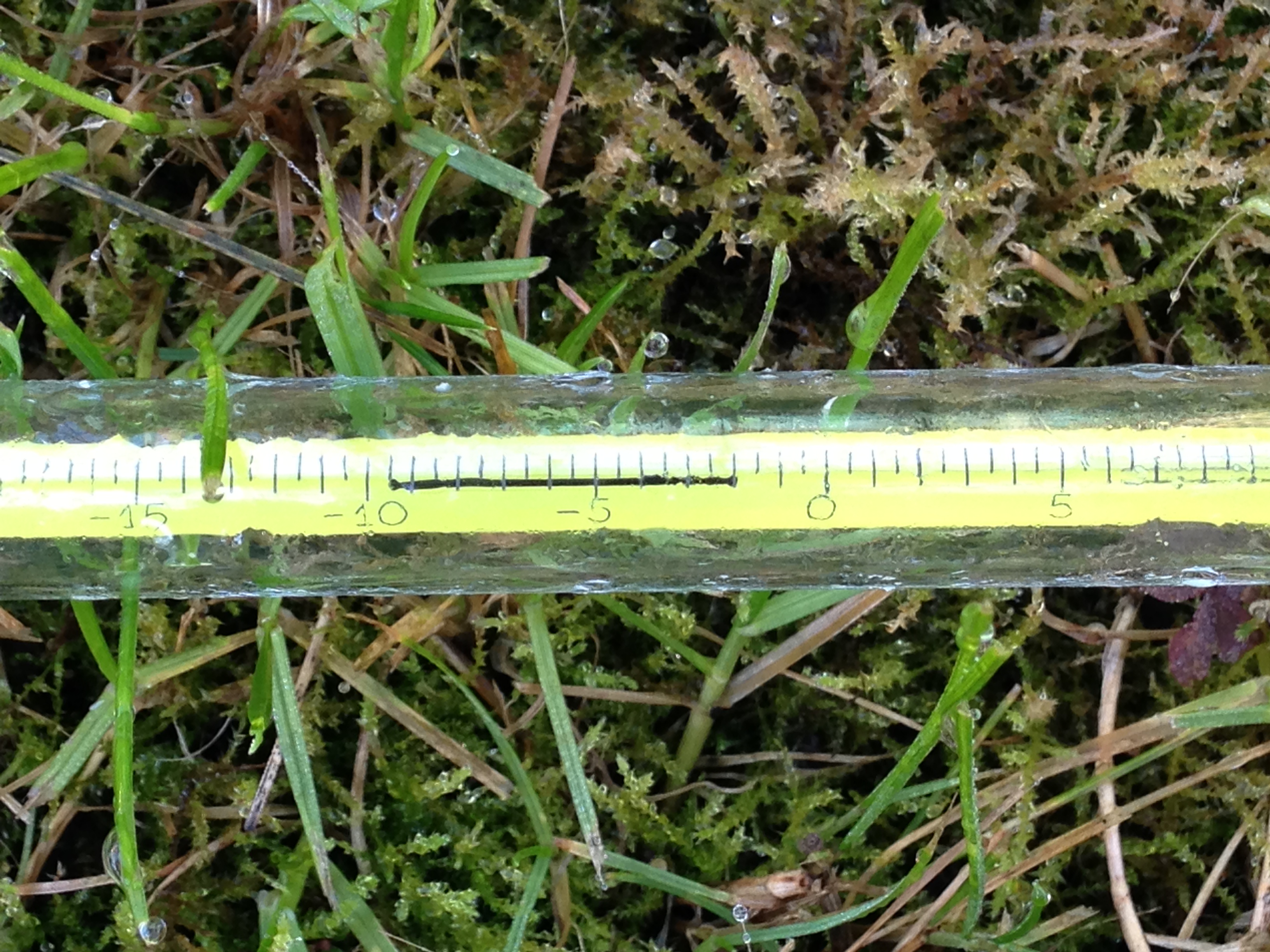
The warmest day occurred on the 6th with 17.2C recorded. The first air frosts of autumn were recorded. The lowest temperature occurred on the 21st when the mercury fell to -4.1C.
The wettest day was on the 3rd when 7.5mm of rain fell. There were only three completely dry days during the month – a real problem for anyone who works outside.
The beginning of the month was foggy
The sunniest days were on 21st and 22nd when four hours of sunshine were recorded.
What has December got in store weatherwise? The models today (December 1st) suggest the beginning of winter will be held at bay with most model output keeping the Atlantic in control of the weather – persistent high pressure to the SW, south and SE and a strong jet stream funneled between this high pressure zone and low pressure to the north and NW.
Winds throughout the first 15 days will be blowing from between SW and NW.
Because of the exceptionally mild November I wonder how accurate my long range method will be in estimating December – but in the interests of consistency I’ll have a crack anyway.
A mean of about 5.1C with 70mm of rain, on the wetter side of average and with average to slightly below sunshine. The highest probability is for rather cold at 50% probability. Average 25% and rather mild, suggested in my winter forecast, comes in at 25% probability.
My November outlook for temperature was way off. I predicted a mean of about 9C, rather mild, but the result was 10.5C, very mild. This chance showed at just 6% probability.
Here follows the full weather diary for November. To view full stats follow this link:http://1drv.ms/1kiTuzv
1st Foggy start, lifted to brief sunny spells early afternoon before mist thickened up again and saw Wanstead Flats’ fireworks cancelled
2nd Foggy start. This cleared earlier than yesterday but sunshine was weak
3rd Cloudy start though turned brighter at 10.30am. Spots of rain at 5.30pm then cloud and mild. Rain at first light
4th Rain to start then briefly brighter
5th Cloudy then rain from 2.30pm to 5.30pm. Mild and damp overnight
6th Short burst of rain at 9am then more at 9.45am. Further short bursts of rain but then mostly cloudy
7th Light rain to start, this grew heavier through the morning with quite gusty winds – the first of the autumn. Heavier showers earlier afternoon before the rain cleared at dusk
8th Cloudy with only brief brightness. A light shower in the evening
9th Cloudy through most of the day and very breezy. F6 at Walkie Talkie
10th Cloudy to start and very breezy. Spots of rain at 2pm
11th Cloudy through the day and breezy
12th Sunny start though cloud tended to fill in as breeze picked up from ‘Abigail’
13th Sunny start , gradually clouding over with some sharp gusty showers and a heavy one at 2pm
14th Light rain, becoming heavier though turning patchy around noon. Heavier again at 2pm. Petering out in the evening
15th Bright blustery start, the wind continuing through the day
16th Cloudy start with some initial brightness, then cloudy. Rain when we turned up at 8.45, heaviest at 10.45pm
17th Cloudy up until 1pm when it started to rain. Breeze began to pick up with gusty evening – 33.6mph was strongest gust since St Jude storm – wind moderated after 10pm but remained breezy
18th Sunny, bright start though gradually clouded over as breeze picked up. Some squally showers around, mostly south of the river with rain lashing off side of buildings
19th Cloudy start with light rain spreading in at 10am. Outbreaks of light rain until lunchtime then a heavier shower at 3pm. Then overcast and cooler
20th Cloudy start – this cleared just before 1pm to give sunny spells. NW’ly set in through the day with ever cooling air. Sleet falling at 7am
21st Cloudy with heavy burst of sleety rain at obs time. Sky quickly broke to sunny spells but a very cold wind. A cold night
22nd Sunny and sub zero to start after heavy overnight frost. Sunny spells through the day, the frost returning at 2.50am
23rd Sunny, frosty start with some alto cumulus. Cloud grew thicker with rain before midnight that was light through the early hours
24th Cloudy start but with light rain spreading in from 11.30am then stopping and staying cloudy. More rain overnight
25th Light rain to start, stopping at 9.40am then cloudy. Temp dropped through the day with sunny spells
26th Sunny start then turned more cloudy at 11am
27th Cloudy start. Some warm sunshine late morning then turned cloudier with strong gusty squall at 7.30pm. Clear spells overnight that led to ground frost
28th Sunny start, clouding over at 10.30am before light rain spread at 2pm and then gusty winds after dark
29th Cloudy and breezy most of the day thanks to Clodagh
30th Cloudy and breezy with occassonal drizzle
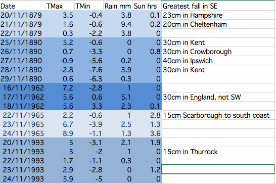
This table shows the stats for Greenwich during spells when there has been heavy snowfall somewhere in the south-east. The figures reveal that it is very hit and miss and that the associated air doesn’t stay cold for long. There is a link to UK-wide November snowfalls here: http://1drv.ms/1PjOB9H
November has produced some potent snowfalls in Scotland and northern England over the past 150 years. These brief shots of cold air, often direct from the North Pole, however very rarely produce anything that can sustain long-lasting low-level snow in London and the Home Counties.
With the GFS weather model occasionally hinting at a blast of polar maritime air I decided to have a look back through the records to see how frequently the capital has turned white during the eleventh month.
Anyone who is familiar with the Objective Lamb Weather Type (LWT) data series will know that there may be an increased likelihood of things turning colder at some point this month. Last month was the joint 5th most anticyclonic October in the LWT series data series that runs from 1871; resulting stats closely resemble both October 1946 and 1962 as being very anticyclonic. Another similar year is 1972.
November 1972 was mild till mid month and then turned much colder with snow in places. November 1962 was cyclonic till the 24th, and then anticyclonic, with a cold northerly outbreak from the 18th for a few days with snow, before turning rather mild. November 1946 in complete contrast to both years, was a mild, dull and very wet month.
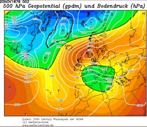
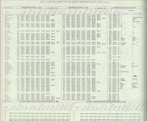
The most impressive November snowy spells seem to have occurred in the late 1800s. These two 500mb reanalysis charts show a cold feed from Scandinavia in both cases.
Snow and sleet falling in the London area is obviously much more common than snow lying. The snowiest Novembers were in 1919 and 1952 when snow or sleet fell for 10 days at Wallington and Hampstead respectively.
Kew saw snow or sleet on 8 days in 1919, while Heathrow and Northolt recorded snow or sleet on eight days in 1952.
This small article appeared on the front page of Reynold’s Newspaper in November 1890
The only decent snowfall that occured in London in my lifetime was November 1993 – and I was abroad for that. I remember my dad mentioning it in a letter written to me as I travelled round China. It arrived in the early hours of one Sunday morning and fell to a depth of five inches.
Given that was the last time London saw a decent fall I won’t be holding my breath that we’ll see any this month – though, if you live in Scotland, the odds are much narrower.
Before 1861 information on snowfalls becomes scarce – at least in terms of correct quantity. However, heavy snowfalls obviously did occur. On November 17, 1816, the Inverness Journal contained this report:
“The winter has commenced with a severity almost beyond example. Frost, rain and snow have been almost incessant during the last week and the greater proportion of corn still uncut or in stocks has suffered material injury.
“We regret to say that several lives have been lost. A postboy of Bennet’s coming from the south was obliged to leave his chaise on the road and would have been lost but for the lights shown from the windows of Moyhall which he reached nearly in a frozen state. The obvious advantage of keeping lights in stormy nights in the windows of houses in the country has thus been illustrated
“The winter it appears has set in with extreme severity in the interior of the continent. At Augsburg on the 19th of November the eclipse of the sun was entirely obscured by a fall of snow which commenced at 7 o’clock in the morning and lasted till noon. The ground was covered with snow a foot in depth. There was a great fall of snow at Frankfurt on the same day and Reaumur’s thermometer showed at from 9 to 10 degrees below the freezing point.”
Perhaps the most impressive, modern day snowfall in the south of the UK occurred around November 18th 1972 when observers recorded 60cm of snow on Dartmoor. Synoptic charts and other data are attached below.
Image courtesy of the Met Office
Image courtesy of the Met Office
Image courtesy of the Met Office
Image courtesy of the Met Office
Inspiration for this piece came from Dr Richard Wild’s PhD study on snowfall which you can find here.
Between 2mm and 3mm is estimated to fall between 6pm and 9pm . Fog cancelled fireworks organised for Wanstead Flats on Sunday
Bonfire Night celebrations are looking a bit damp tonight with rain spreading in just at the time many will be looking to light the fuses of fireworks as darkness falls.
According to the Euro4 model revellers can expect light but steady rain between 6pm and 9pm – annoying given that Sunday night’s festivities on Wanstead Flats were cancelled thanks to thick fog forming during the late afternoon as the sun began to set.
Wanstead Flats has put on some spectacular Guy Fawkes’ nights over the years. I didn’t realise quite how many years until I stumbled upon this old British Pathe clip which shows nurses at Wanstead Children’s Home building a huge bonfire for the children in 1934.
The footage shows the nurses struggling to get the Guy atop the bonfire, using numerous ladders, while the children, including 12 sat in an old perambulator, look on. The stats for the day reveal that the temperature fell to a chilly 2.7C after a day high of 7.9C. There was also some drizzly rain, though less than 1mm.
The Aldersbrooke Childrens Home for Waifs & Strays is still there in Brading Crescent on the Aldersbrook Estate, although the five lodges have been converted to flats.
In 1907, the West Ham Guardians purchased the Aldersbrook site. In 1911, five receiving homes were completed. The homes were called lodges and were: Elizabeth Fry Joseph Lister, Tom Hood, Edward North Buxton and William MorrisA bit of history…
In 1913, a workshop, for training of the older boys and girls was opened. Skills learnt were in tailoring, carpentry, laundry work and needlework, under skilled industrial trainers.
In 1930, on the 1st April, the ownership of Aldersbrook homes and the leases of the Scattered Homes, were under the 1929 Local Government Act, and by agreement with the Essex County Council and the West Ham Corporation, vested in the East Ham Corporation who are required to continue to receive destitute children from the Essex County Council and West Ham, formally comprised in the West Ham Union area.
On 27th May 1933, the Aldersbrook Children’s Homes new nursery was opened. The County Borough of East Ham owned it. Alderman T.W.Burden, Chairman of the Public Assistance Committee, opened it. The Mayor of East Ham, Alderman G.H.Manser J.P, proposed a vote of thanks, which was seconded by Alderman C.W.Brading J.P, and supported by Alderman Mrs Taylor (East Ham) and Councillor G.Doherty, of West Ham. After the official opening, the older children (14 to 16 years old) of the homes put on the play “David Garrick”.
The superintendent of the home was W.T.P. Steele, and the matron was E.M.Steele. S.R.N. The building was described as being divided into three sections – ground floor, babies under twelve months and toddlers one to three years, first floor staff. Accommodation is given for ninety infants under three years. Wards are provided for these age groups were newly admitted children will be housed for three weeks before being sent to the general rooms. Two ranges of isolation rooms are also provided where “suspects” can be nursed to reduce the risk of infection. The south end of the building is allotted to the youngest or cot babies and comprising of long dormitory with sun rooms at the end, designed to catch the winter sun.
The former Aldersbrook Children’s Home is still there in Brading Crescent but has been converted to flats
The programme went on to describe the building as being the most modern of children’s institutions. The building has a veranda at the front. The first floor has 21 separate staff bedrooms. The building had an oil fired heating system and flooring with fire resistant Terazzo material whilst the children’s play room and dormitories are protected by rubber flooring. The lighting and power points are controlled by locking device to prevent the children switching them on and off. The building was built by Messrs Hammond & Barr Ltd Chelsea.
The Nursery is now gone and the Aldersbrook estate covers the area, although the recreation Hall, the lodges (See photo) and the porters lodge are still there.
The incident of frosts during the season from October to May. There has been a general uptick overall since 1999/2000
1934 and this year, together with the last couple of years, is a far cry from my memory of Bonfire Night being a frosty affair – despite the fact that frosty nights during the season from October to April have been showing an uptick since 1999/2000.
The synoptic chart on November 5th 1934 portrays an unsettled regime
This October was the coolest since 2012 though the mean of 11.7C is just 0.1C below average – nearly 2C colder than the same month last year.
The last week of the month saw the leaves turning in earnest. The horse chestnuts, such as this one in Wanstead Park however, turned much earlier because of the leaf miner pest
A persistent anticylone around mid-month pumped quite cool air from the north-east for a time, prompting some cold nights. Though we have yet to experience an air frost this autumn the ground temperature fell below freezing on five nights – that’s five occasions more than last year: -2C was recorded during the early hours of the 8th.
The month was rather dry: some 46.8mm of rain fell which is 70% of what we can expect in an average October. The wettest day was the 27th when 19.4mm fell. The heavy rain in the early hours of the 28th was quickly replaced by sunshine and a stunning day followed.
Just over 91 hours of sunshine were recorded – that’s 86% of what we can normally expect in an average October.
What has November got in store weatherwise? The models today (November 1st) suggest this week will see a gradual decline in conditions overall as the ridge from Europe weakens and weak Low pressure edges up from the south and SW. Thereafter it looks like winds will settle SW’ly as high pressure relocates to the south of the UK, bringing this area mild temperatures and mostly dry and bright conditions – though a little rain will be possible at times. Overall the models continue to have little appetite to serve us up anything remotely cold and stormy.
My long range outlook method suggests that November will be average to rather mild temperature-wise, a mean of about 8.9C, at 56% probability. The next highest probabilities are for rather cold or cold, at 18% probability. The chance of a very mild month comes out at just 6% probability.
The highest probability for rainfall is 69% for something average to rather dry, between 37mm and 59mm. A wet November comes in at 20% probability.
My data for sunshine only stretches back to 1878. The signal is for something average, at 60% probability.
Looking beyond November it is notable that October 2015 was very similar to October 1997 – the year another strong El Nino occurred. A very mild winter unfolded from 1997-98, though I’m sceptical about how much influence ENSO has on our part of the world.
With the sun lower in the sky at this time of year there’s often a great opportunity for a decent sunset
My October outlook for temperature was good in that I estimated that there was a 44% chance of the mean being average. My rain estimation was way out in that a signal for a rather dry October was only a 22% probability – though bearing in mind that the probability for a wet October was only 33% it is not surprising the outcome was wrong.
Here follows the full weather diary for October…Full stats for the month here:http://1drv.ms/1rSfT7Y
1st Sunny with just a few wispy clouds. Heavy overnight dew.
2nd Sunny and clear all day and evening. Mist thickened overnight with fog elsewhere in the UK.
3rd Misty start and cloudy till midday. Evenutally cleared to leave sunny spells. Cooler than yesterday.
4th Sunny start but with a few cumulus developing during the day. Clouding over during the night with few drops of rain from high-level feature before obs time.
5th Cloudy start with rain spreading in after midday, this being steady on and off into evening before turning to drizzle late evening and lasting into early hours. Another outbreak of rain at 9.30am to obs time.
There were five ground frosts during the month of October
6th Rain to start, some of it heavy. Drying up a bit at 11.30am. More rain in the evening and overnight into the early hours. Rain again at 9.20 until obs time.
7th Cloudy start but with rain moving in again. This rain dried up a bit at 11am but then more rain at 2.30pm before petering out and clearing overnight to leave it cold.
8th Sunny, clear start with just a few cirrus. More cloud at noon and through the day. Cleared at dusk to give a cold night and heavy dew.
9th Sunny start but cloud bubbled up from noon to give cloudier periods.
10th Bright start though stayed mostly cloudy and cool. Milder overnight than of late.
11th Sunny start with a bit more of a breeze. Some alto-cumulus late on made for a stunning sunset. Cloud overnight held up temperature.
12th Cloudy start, some brightness at 11am.
13th Cloudy, cold start with cloud off North Sea making it feel colder. Cloud was very thick at 3pm with drops of drizzle.
14th Clearer periods overnight saw temperature fall sharply but too much wind for frost.
15th Sunny with just a few cumulus – very cold wind though. Cloud thick enough at times for brief showers through day. Quite overcast at night
16th Cloudy start though with some brightness. Strong easterly breeze.
17th Cloudy though warmer than past week. Felt a bit muggy.
18th Cloudy and breezy start, cloud persisting through the day.
19th Bright start and was more glimpses of sunshine than past few days. However, cloud returned with a vengeance last afternoon – felt like it was getting dark at 5pm.
20th Cloudy all day. Clearer overnight.
21st Cloudy start. This turn to long sunny spells and a pleasant afternoon.
22nd Rain to start which fell until 2.30pm. Then outbreaks of rain into the afternoon. Cloudy and damp overnight.
23rd Bright start though mostly cloudy through the day.
24th Cloudy all day. Feeling colder.
25th Cloudy start with light rain around 10.40am then intermittent. Very heavy burst of rain after dark before the skies cleared to leave a cold night.
26th Bright start with cloud breaking to long sunny spells – pleasant in the sun. Temp fell away quickly at dusk. Precip was dew accumulation.
27th Sunny start. Some cloud developed through the day but then largely melted away to leave a warm late afternoon.
28th Cloudy start. This broke to sunny spells into the afternoon in Rye. Light rain seen in Rye at 8pm – this turned heavier into the evening but most fell at dawn.
29th Bright start but quickly clouding over with rain in the evening and overnight.
30th Light rain and drizzle to start then cloudy all day and overnight.
31st Bright start, the cloud gradually clearing to leave a warm afternoon.
This September was the coolest since 1993. The average mean of 13.4C is 2C below average – a surprising statistic given that the month ended with many bright and sunny days with respectable temperatures. But, with the wind in the east, caused by an anticyclone anchored to the north of us at the end of the month, the air was dry and allowed temperatures to fall smartly away after dark. The average minimum temperature was just under 8.8C, 2.3C below average and the coldest since 1986.
The month was rather dry: some 42mm of rain fell which is 81% of what we can expect in an average September. The wettest day was the 16th when 17.6mm fell.
Just over 140 hours of sunshine were recorded – that’s ‘on the nose’ of the monthly average and 20 hours more than was recorded during the very dull August.
What has October got in store weatherwise? The models today (October 1st) suggest an end to the fine and sunny weather as high pressure declines and is replaced by a trough moving up from the southwest on Monday. Less clear is how the weather evolves from then with the majority of models showing this feature opening the door to a lengthy period of SSW winds and possible rain at times. However, the rain would become more restricted to our northwest as pressure builds from the continent. So a return to something more autumnal looks likely though temperatures will remain on the mild side, especially at night.
This chart shows the low pressure system that brought September wettest day for this area
My long range outlook method suggests that October will be average temperature will be average temperature-wise, a mean of about 11.8C, at 44% probability. The next highest probabilities are for something cool, at 22% probability. Something rather cool or very cool comes out at 11%. There appears no chance for a mild month.
The highest probability for rainfall is 33% for something rather wet: between 84mm and 100mm. The next highest probabilities is for an average, rather dry and dry October at 22%.
My data for sunshine only stretches back to 1878. The signal is inconsistent so I would guess sunshine will be average.
My September outlook for sunshine was good in that I estimated that there was a 60% chance of average sunshine. Less good was the finding that there was only a 23% chance of a dry September – the highest probability was for something average. And my temperature estimation put the probability of a rather cool September at only 14%. So, all in all, not great.
Here follows the full weather diary for September…Full stats for the month here:http://1drv.ms/1rSfT7Y
1st Cloudy start though with some brightness. Small shower mid afternoon which was the edge of large storm that affected Essex.
2nd Sunny bright start though with lots of cloud from noon. Lots of convection.
3rd Cool, cloudy start. Some brightness but feeling cool in the wind. A few spots of rain.
4th Bright start with some sunshine tempered by the breeze. Mostly cloudy all day.
5th Light rain to start with brighter spells. Problem of being on the edge of high pressure. A sunny afternoon.
6th Sunny start with just a few clouds during the day.
7th Sunny start but cloud gradually increased during the day.
8th Cloudy start, overnight ‘rain’ was dew. Mostly cloudy all day. Warm overnight.
9th Cloudy start but a few holes appearing as the day wore on and sunshine at 1330.
10th Sunny start though with cloud bubbling up sunny spells followed. Clear with heavy dew overnight.
11th Sunny start with wispy cirrus – more cloud bubbling up during the day.
12th Cloudy start over overnight rain. This breaking up toward late morning to leave a sunny spells afternoon.
13th Cloudy start – this breaking up toward noon to leave bright afternoon. Some rain overnight.
14th Cloudy start, rain arrived soon after 10am and lasted over an hour. Then bright spells and more showers through the day and into the evening and overnight.
15th Cloudy start with heavy shower moving in at 12.30pm. Showers cleared through to leave cloudy early evening.
16th Cloudy start with rain spreading in at 12.30pm. Some heavy bursts through the day. Rain all the way in to work and torrential rain coming back from school at 5.30pm. Bursts through the evening and light drizzle was falling on way home at 1am, tending to peter out.
17th Sunny start tending to cloud in more.
18th Bright but cloudy start with clouds bubbling up. A heavy shower by 1pm.
19th Sunny all day with odd cloud. Warm in sun.
20th Sunny all day, any cloud decreased.
21st Spots of rain just before obs time. A mostly cloudy day. Heavy, showery rain between 5.30am and 7.30am.
22nd A cloudy, chilly day with rain after noon.
23rd Sunny, gin clear start. Clouding over by 2pm with rain at 1am.
24th Bright start after rain overnight. Sunny spells developing – a late shower at 1534. Dry and clear overnight.
25th Sunny start though with cloud bubbling up the sun disappeared at times. Cold overnight with a heavy dew.
26th Sunny and clear to start, though with cloudier periods through the day.
27th Sunny clear start with a few clouds bubbling up through the day. Mostly clear for lunar eclipse totality at 3.11am.
28th Sunny start with long clear periods during the day.
29th Mostly sunny with just some cirrus.
30th Sunny start with just a few cirrus. Stronger breeze than yesterday.
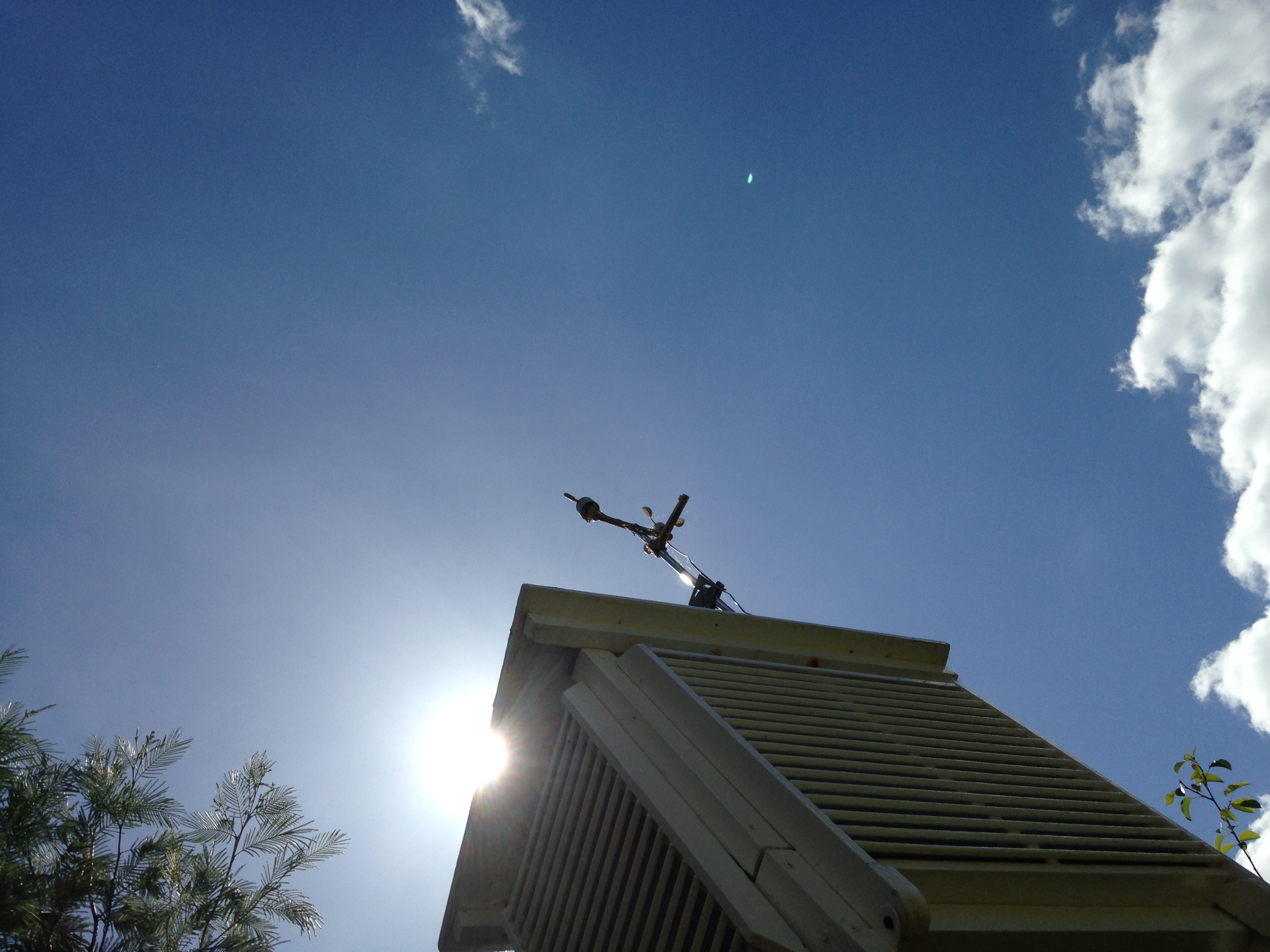
Summer 2015 has got quite a bad press over the past couple of weeks but it hasn’t really been that bad overall in this area. And, as ever with the weather, it wasn’t without interest.
Though the summer was wet overall it was very dry well into July
Two extreme records were broken: The maximum on the 1st of July of 36.1C and the minimum on the 30th of July of 6.9C. There were also a couple of cracking thunderstorms.
Mean temperature for the three months was the lowest since 2012, the same year that saw more rain than this summer’s 167.7mm. Both 2012 and 2011 were a fair bit wetter than this summer and this season’s rainfall wasn’t a patch on some of the washout summers of my youth – both 1985 and 1987 were at least 150% wetter than summer 2015.
More notable was the lack of sunshine – it was the dullest summer since 2002.
Looking beyond Wanstead the perceived poor summer elsewhere was largely caused by cooler than normal sea temperatures west of Ireland, together with warmer water around the Azores. Simon Keeling explains this well here.
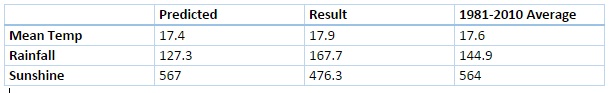
Three months ago I predicted that summer would be broadly average temperature-wise with average to slightly below average rainfall and average sunshine. So how did the forecast do?
In terms of temperature my predicted figure of 17.4C was 0.5C lower than the result. My rainfall prediction was only 76% of what actually fell and I over-estimated sunshine by 16%.
Despite some of the dire reviews of summer elsewhere in the UK there were some fine spells
This August was the third dullest since 1881. I’ve seen mentioned recently that August used to be regarded as an autumn month. For the past couple of years the final ‘summer’ month has been very disappointing for anyone looking for fine weather – much more akin to September or even October.
A storm in south London gave this eerie light seen at Southwark Bridge on the 5th
The first third of the month began pleasantly enough with a couple of days exceeding 27C. And on the 22nd the temperature reached 31.4C, only the third occasion that the mercury has risen above the 30C mark this summer. But summery highlights were few and far between.
Just under 120 hours of sunshine were recorded – that’s 62 per cent of the monthly average, the dullest August since 1968.
There were six occasions when the maximum exceeded 25C. Mean temperature for the month was 18.2C, which is on the nose of the 1981-2010 mean. Rainfall of 79.8mm was 159% of average. The wettest day occurred on the 24th with 18.4mm of rain.
What has September got in store weatherwise? The models today (September 1st) suggest a very slow progression of high pressure ridging into the UK from the west this weekend. Until then a cool northerly flow will persist with a mix of sunshine and possibly heavy showers. Most models suggest that by the end of the week a trough will run south, bringing a spell of cloud and rain before high pressure from the west eventually cuts off the cool northerly, replacing it with little or no wind, warmer sunny spells by day and misty nights – typical late summer / early autumn weather. Models then split over what will happen with the high next week. It could stay settled or, according to the ECMWF and GFS, the start of a breakdown could happen at the end of next week.
The synoptic chart shows the frontal set up that brought the greatest daily rainfall on the 24th
My long range outlook method suggests that September will be average temperature-wise, a mean of about 15.4C, at 52% probability. The next highest probabilities are for something rather warm and warm, both at 14% probability, though something rather cool also comes out 14% probability.
The highest probability for rainfall is 45% for something average. The next highest probability is for a dry September, at 23%. Rather wet works out at 14%.
My data for sunshine only stretches back to 1878. There is a 60% chance of average sunshine in September.
My August outlook was OK – I went for an average to rather cool August. I also said there was a 73% chance of a duller than average August – so not bad overall.
Here follows the full weather diary for August…Full stats for the month here:http://1drv.ms/1rSfT7Y
1st Bright but hazy start. Cloud gradually thinned to give a sunny afternoon with just a few clouds. Warmer.
2nd Sunny start with decreasing cloud.
3rd Sunny start quickly turned cloudy and blustery with brief burst of rain at 4pm. Then dry with variable cloud overnight and breezy.
4th Bright start but lots of cloud around and breezy. This lasting through the day.
5th Cloudy start, a few bright intervals and a strange light as thunder clouds passed to the south. Some light rain.
6th Cloudy start but cloud thinned to become sunny just before 2pm. Then variable cloud through the day with another eerie sunset.
Many places around the coast recorded far more sunshine than Wanstead, typical of the type of weather experienced in August
7th Sunny start though was very cloudy at times.
8th Bright start and cloud quickly melted away to leave a stunning, sunny day in Sussex and Camber. Some cloud was seen a few miles inland but even this eventually melted away. Night turned chilly with heavy dew by dawn.
9th Sunny until 3pm then a bank of cloud brought cloudier spells. Warm overnight.
10th Bright start with sunny intervals. A burst of rain at 2pm damped the ground then it was mostly cloudy for the rest of the day.
11th Cloudy, calm start, spits and spots of rain before more organised rain in evening.
12th Cloudy start then brief sunny spells late morning before clouding up again. Warm front stalled over South Coast dumping 32mm on Herstmonceux.
13th Cloudy with rain spreading in late morning, this lasting until 3pm with odd burst of drizzle for rest of night. Some 78mm in Polegate and flooding reported in Brighton.
14th Cloudy and very humid with some brightness late morning. Showers returned at 3.30pm then more general rain arrived at 8pm.
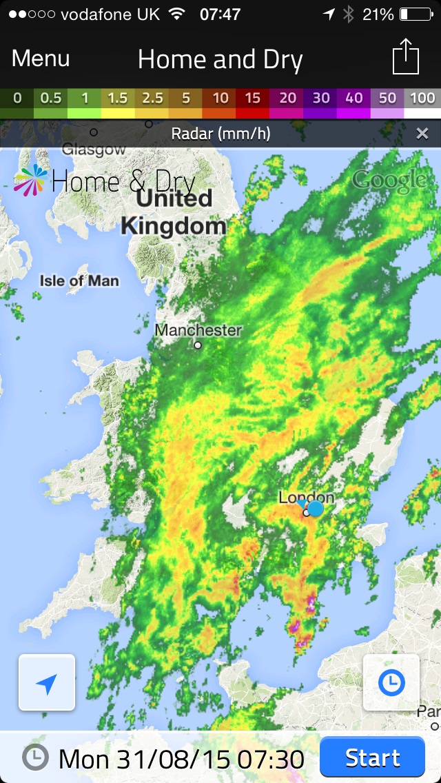
This radar shows the area of rain that brought over 10mm to Wanstead on 31st
15th Sunny start, clouded over at 2.30pm but then became sunny again at 5.30pm. Clear spells overnight.
16th Sunny start then cloudier in the afternoon. Very still air though made it feel pleasant.
17th Sunny start then cloudier around lunchtime. Sunny spells late afternoon though sun didn’t feel that strong.
18th Sunny start though quickly clouding over and dull. Some spots of rain on way to airport but dry in Wanstead.
19th Sunny start then going downhill with rain in the evening and overnight.
20th Bright start, clouding over.
21st Bright start before breaking to sunny spells and warm.
22nd Long sunny periods and 3rd occasion of 30C.
23rd Bright start but cloud built to give rain between 12.45 and 2.45pm.
24th Dull, rainy with rain between 9am and 11am.
25th Rain between 1pm and 3pm. Showers overnight then more general rain at obs time.
26th Dull and rain morning with squall blowing through at 1.30pm. Brightening up by 5pm then some bright spells late afternoon.
27th Bright start but with heavy cloud present. A brief shower in the afternoon before a clear evening made it chilly overnight.
28th Sunny start with light breeze, tending to cloud over middle part of the day. Skies cleared again to give sunny, pleasant evening.
29th Sunny start, cloud filled in by 3pm then rain arrived at 4pm, with moderate bursts.
30th Cloudy and humid start. Cloud stuck around all day – airless and therefore felt pleasant.
31st Cloudy start after overnight rain. The rain soon returned after 10.20am and fell, often heavily through until 12.30pm.


 Other daily records were broken including for daily mean temperature: 14.3C on Boxing Day smashed the previous record set on December 4th 1985 by 0.4C. This day also saw the highest daily minimum for December recorded: 13.5C.
  The lowest temperature occurred on the 8th when the mercury fell to 2.4C.


 So my guess for the weather on Christmas Day this year is for a maximum temperature of 7C after an overnight low of around 1C. With a 60% chance of rain in a stiff westerly wind there is a chance of something sleety falling.


You must be logged in to post a comment.