Category Archives: UK snowfall

A 100% guaranteed snow risk for rest of winter

This weekend marks the halfway point through winter. Though December brought some snow January has been broadly average – really cold air has been absent with only one air frost recorded this month.

The cloudy, anticyclonic type weather is about to be replaced, however, with cold, polar maritime air this week set to flood down from the north-west.

Since December 1st, Wanstead has recorded 12 air frosts – about average. The coldest night was just -3.7C. The current mean temperature this winter to January 14th is 5.7C with rainfall 111mm – statistics that are remarkably similar to the winters of 2012/13 and 1990/91. Both those seasons were followed by cold late winters, February 1991 saw some of the deepest snow that I’ve ever seen in the south-east; the mean temp for that February finished 1.6C, the 14th coldest in the local series going back to 1797.

Using my method for finding patterns stretching back over 50 years to forecast this winter I picked out years that were +/- 10% of the 2017/18 total rainfall. From these I then weeded out the seasons where the average temperature was +/- 10% of the 2017/18 mean.

This gave a list of just two other winters with similar temperature and rainfall. Both winters had above average ‘snow lying’ days, the long terms average for this area being six.

Before any readers accuse me of going all Daily Express with the title of this blog I would emphasise that this piece doesn’t echo the latest long-term output from the models, which are in a state of flux, caused mostly by the evolution of the explosive cyclogenesis expected midweek. It is simply a reflection of what the local data is telling me.

A 100% guarantee of snow isn’t such a fantastical claim as, during the past 10 years, there is only one winter when no snow fell or was lying at 9am!

In terms of the rest of the winter, outside of the models, I would expect a couple more snowfall episodes, similar to the ones we had in January and February 2013. A repeat of February 1991, while not impossible, looks unlikely – there seems to be far too much energy coming from the Atlantic to allow the all important Scandinavian / Russian high to form and exert its influence far enough west for long-lasting cold and snow.

Record low pressure of February 25th 1989

The low pressure system that brought widespread rain and snow on Wednesday reminded me of another event where very low atmospheric pressure helped many low-lying areas experience heavy snowfall.

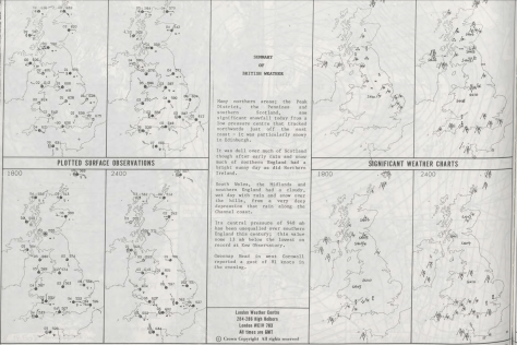
The unusually deep depression ran along the Channel on February 25th 1989.  Its central pressure of 948mb has been unequalled over southern England since, the value was some 13mb below the lowest on record at the Kew observatory.

Though temperatures reached around 6C in the morning they fell away as the day progressed. This and falling pressure helped turn the rain to snow.  Accumulations were fairly wet in the London area but further north over East Anglia some notable falls were recorded.

greenwich

MetO 25021989
Courtesy of the Met Office

GFS 25021989

summary 25021989
Courtesy of the Met Office
summary2 25021989
Courtesy of the Met Office

Hyperlocal forecasting of snow

The knife-edge situation for snowfall across England today set me off wondering if there was a way to forecast snow locally to a given location.

Temperature, dew point and altitude are all crucial to forecasting snow, as is precipitation intensity that can lower the wet bulb temperature, the ‘rain turning to snow’ scenario. Less well known is the role air pressure plays in these events, such as the one on December 10th which caught many forecasters by surprise by its intensity.

While various models continually improve in their skill at warning us of impending rain / snow events that often cause chaos, their resolution can still struggle and especially when the event more or less becomes a nowcast.

In the International Standard Atmosphere (ISA) there is a 1 hPa difference for each 30 feet vertical change in height in the lower levels.

If we take a forecast pressure as 970 hPa, the difference between standard conditions (1000 hPa) and 970 hPa is thus: 30 hPa

30 hPa * 30 = 900ft height variation.

You then consider local altitude: in my case 18m (59ft)

So 59ft – 900ft = 841ft  (256m)

A simple table, therefore, to consider air pressure is thus.

1000 hPa = 0m
995 hPa = 27.6m
990 hPa = 73.3m
985 hPa = 119.1m
980 hPa = 164.8m
975 hPa = 210.5m
970 hPa = 256.2m
965 hPa = 301.9m
960 hPa = 347.7m
955 hPa = 393.4m
950 hPa = 439.1m

Looking at the system today the pressure rose quickly after the centre passed, leading to a 1hr (at best) window of snow falling. As the pressure rose, and the temperature picked up only slightly the snow turned back to sleet and then rain.

pressure
Pressure rose quickly on the 27th, far more rapidly than the 10th – the pressure on this day stayed below 976mb from 8am until 3pm, allowing snow to accumulate. Temperature on the day was also around 0.5C cooler


pressure 10122017
Pressure fell to its lowest point 970.3mb at 1159z on the 10th

temperature

temp trace 10122017
The temp and dew point hardly moved from 9am

wet bulb

chilterns

http://weatherfaqs.org.uk/node/152

http://aeropowerflightschool.com.au/how-to-calculate-pressure-heightaltitude/


London Grimness index

The last three months in east London have been sunnier than average – hard to believe as we move into a regime of easterlies that will bring showers and anticyclonic gloom.

Screen Shot 2017-12-21 at 21.30.14
A sunless outlook from the Met Office last December

With no sun and short days  it is no surprise that many are probably already feeling short-changed in the solar stakes.

A blog by XMetman on a ‘grimness index’ got me thinking how London fairs in terms of sunshine, temperature and rain in any given winter season.

Using the same criteria, and assuming that most people welcome sunshine, it can be seen that since the least grim winter of 2007-08, the season, over the past 10 years, has been growing steadily worse.

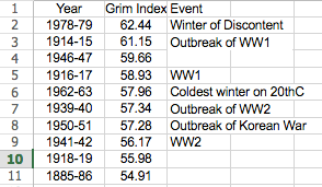
Screen Shot 2017-12-21 at 21.51.54The grimmest winter, considering statistics back to 1881, was, ironically, the 1978-79 ‘Winter of Discontent’ when, again ironically, ‘Sunny Jim’ Callaghan was in Downing Street as widespread strikes coincided with the coldest winter for 16 years. On looking at the Top 10 of grim winters it is striking how most coincide with depressing world events, the Great War, World War 2 and the Korean War!

grim index

The Tory ‘Crisis? What Crisis?’ campaign was probably my first memory of a general election broadcast.

December 10th 2017: rain turned to snow

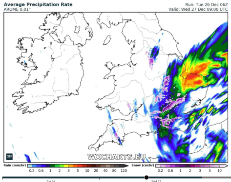
Today’s snow came thanks to an area of low pressure that tracked further south than forecast.

Screen Shot 2017-12-10 at 17.38.33
Wanstead Park

‘Xanthos’ brought several hours of precipitation, 21.3mm in all to 3pm. Associated precipitation started as rain in Wanstead at 4am, turning to snow at 8am and quickly settling on all surfaces. By the observation time at 9am about 1cm had accumulated as the snow turned heavier.

Snow continued to fall through the day though, because soil temperatures are still relatively warm, the snow thawed from below and accumulations locally were restricted to around 5cms.

There is still a full, slushy cover on lawns at nightfall.

met office fax 06z10122017

low xanthos

pressure 10122017
Pressure fell to its lowest point 970.3mb at 1159z
ground temps
Had 0-10cm ground temps not been so warm today’s snow would have been a lot less slushy here

A repeat of December 1990 this weekend?

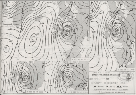
The outlook for possible snow over the weekend reminds me of a similar synoptic set-up in December 1990 that left large parts of the Midlands northwards covered in deep snow, but that delivered only cold rain to the London area.

The situation in 1990 is explained on the excellent Booty Weather site.

“A low formed dramatically over central England on the 7th, large quantities of rain, turning in many places to snow, fell on its western and northern flanks. On the 7th and 8th very heavy snow fell over northern England, Wales, the Midlands and south west England, with heavy drifting in gale force winds, causing considerable disruption to traffic and cutting power lines.

coventry“The snow did not freeze, however, but melted very rapidly during the next few days, as the temperature rose a little. By late on the 8th, many parts of the Midlands had 20cm or more of lying snow. Acocks Green, Birmingham, reported 42.5cm on the 8th. The Peak District had 38cm at Middleton and 25cm at Winksworth. Newcastle under Lyme reported 28cm, and many other places had more than 20cm. Drifts up to 60cm on motorways in the Derby area, and at Carlton in Coverdale, near Leyburn, a report of 240cm. Snowfall on the 9th in the Dorchester area in 1990 was the heaviest pre-Christmas fall in that area since 9 December 9th, 1967.”
My stats in London suggest that the system was a bit of a non-event here. Another account of December 1990 is covered here.

rain


met office
Met Office synoptic charts, general situation and surface obs for December 8th 1990

story