Though there were no records broken August 2016 goes down as a mighty fine summer month, the warmest for 12 years. The mean of 19.5C was 1.3C warmer than average and only 0.1C cooler than 2004.
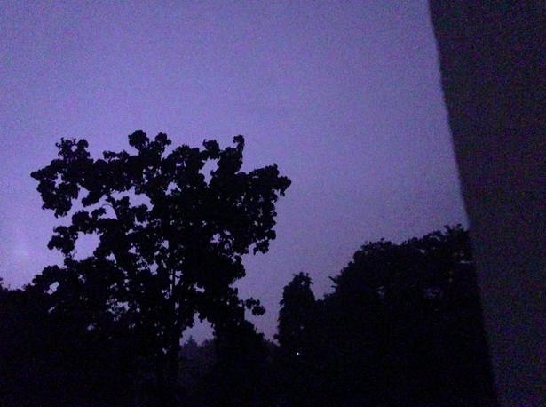
Grasslands around Wanstead Park have gradually turned brown because of the lack of rainfall
The month ended a three-year run of poor or so-so Augusts: in terms of mean temperature the month was the 10th warmest in a local series going back to 1797.
It was another very dry month: just 11.9mm fell, 24 per cent of average, the driest August since 2003 and the 12th driest in the local record.
The month only falls down in terms of impressiveness when sunshine hours are considered. Some 192 hours were recorded, the 59th sunniest since 1797 – 1995 had 80hrs more sun.
Air frosts: 0, Ground frosts: 0
So what has September got in store weatherwise? The models on the 1st suggest the month will start mixed, though any precipitation will be below average. Temperatures remaining on the warm side.
Beyond the grasp of the models my long range outlook method is again hampered by a very dry August. However, the data I do have suggests an average month at 100 per cent probability.
A wetter than average month looks most likely at 75% probability.
The rainfall probability makes me wonder whether we are in for a very unsettled second half of September, the Atlantic cranking into life with the remnants of tropical storms and hurricanes having an ever-increasing influence as the month progresses.
So to sum up: mean 15.3C (average), rainfall 162mm (300%), sunshine 140 hours (100%).
My August outlook for temperature was good. I predicted a mean of 19C (outcome: 19.5C). It was drier than I thought: 30.3mm (outcome: 11.9mm). Sunshine was poor: 239 hours (outcome: 192 hours).
Here follows the full weather diary for August…Full stats for the month here:http://1drv.ms/1rSfT7Y
1st: Cloudy start to 1pm. Rain started at 5pm through to 10pm. A brief interlude before more light to moderate rain through the night 4.30am, then drizzle
2nd: Damp, miserable start – the rain became light to moderate in the early afternoon before drying up – very high dew points through the day.
3rd: Bright and breezy with variable cloud.
4th: Bright start with variable cloud and sunny spells.
5th: Good sunny spells all day – perfect summer’s day, not too much humidity – though an isolated shower passed over at 8pm.
6th: Sunny, clear start. Lots of sunny spells during the day.
7th: Bright start though very breezy. Cloud decreased through the day to leave a gorgeous late afternoon and evening.
8th: Sunny, clear start with lots of fair weather cumulus throughout the day. Cloudier spells mid afternoon.
9th: Sunny with fair weather cumulus up until noon then cloudy afternoon.
10th: Sunny with fair weather cumulus, variable throughout the day. Breezy.
11th: Cloudy start with very brief light rain, barely enough to damp ground. Some sunny intervals later and bright and warm.
12th: Sunny start with a few clouds. Turned gin clear at 11am and stayed clear all day. Feeling hot.
13th: Bright start but turning cloudier. Sunny intervals PM.
14th: Cloudy start breaking to some long sunny spells. Feeling very warm in the sun.
15th: Bright start soon turned sunny with a clearance at 1pm.
16th: Bright start though a lot of haze around. Sunnier later though still hazy.
17th: Sunny with patchy cloud to start, this clearing late morning to leave a clear if rather hazy afternoon.
18th: Sunny if a bit hazy to start, this tending to decrease to leave warm sunshine.
19th: Cloudy with rain threatening. Low cloud at Stansted. Brief rain in afternoon then cloudy.
20th: Dull and overcast at 9am. Burst of heavy rain at 10.15am clearing to sunny spells at noon 30. Rain between 7pm and 8pm and 3am and 4am.
21st: Bright start. Sunny intervals till 3pm then sunny spells.
22nd: Bright after earlier rain at 0719 then sunny spells.
23rd: Clear and sunny start with a few cirrus clouds through the day. Hot.
24th: Sunny, gin clear start. Patchy cirrus through the day. Hot.
25th: Lots of altocumulus and sunny spells but felt sultry due to high dew points.
26th: Cloudy start but gradually decreased to leave clear pm.
27th: Overcast but bright start. Brightness through the day but hazy. Some heavy storms further north.
28th: Overcast until early afternoon, 5 minute shower at 2pm then sunny intervals..
29th: Bright start then sunny spells and cirro cumulus gradually clearing to leave a sunny evening and clear night.
30th: Clear and sunny start.
31st: Bright start though cloud filling in by 3pm, clearing again at 8.30pm
There was plenty of interest in the weather last month even though the overall stats suggest July 2016 wasn’t that remarkable.
The sunset on July 9th was spectacular
Most notable was temperature: the warmest minimum on record for this area (21.1C) was recorded during the early hours of the 20th – coming hours after the hottest day of the year: 33.5C – the 14th hottest day on record. The mean temperature of 19.5C was a degree warmer than average, the 18th warmest July since 1797.
Rainfall was very sparse. A total of 17.3mm fell during the month, that’s 40 per cent of average, the driest for six years and the 19th driest in the series going back to 1797.
After a very dull start to the month sunshine was always going to struggle: just under 172 hours were recorded – that’s 89 per cent of average and marginally down on last July.
Air frosts: 0, Ground frosts: 0
The temperature didn’t fall below 21.1C on the night of 19th July, making it the warmest minimum on record in this area back to 1959
So what has August in store weatherwise? The models on the 1st suggest the month will start with a mixture of sunshine and showers. At the end of this week there are indications of a change to warm and later very warm weather.
Beyond the grasp of the models my long range outlook method is hampered this month because of the very dry July. However, the data I do have suggests a rather warm month at 50 per cent probability. The ‘worst case’ scenario suggests something average, a contrast to the past couple of Augusts which have been poor. Perhaps we can look forward to another reasonable summer month, defined by plenty of fine, at times hot, weather – though anyone looking for unending days of 30C and higher will be disappointed.
A dryer than average month (possibly very dry) looks most likely at 50% probability. A very sunny month looks most probable.
So to sum up: mean 19C (0.8C above average), rainfall 30.3mm (60%), sunshine 239 hours (123%).
My July outlook for temperature was good. I predicted a mean of 18.8C (outcome: 19.5C). Rainfall was very poor: 50mm (outcome: 17.3mm). Sunshine not badr: 171.9 hours (outcome: 190 hours).
Here follows the full weather diary for July…Full stats for the month here:http://1drv.ms/1rSfT7Y
1st: Cloudy with sunny intervals. Some sharp showers.
2nd: Bright start though breezy. Very heavy shower at 1740.
3rd: Sunny though with lots of cumulus.
4th: Sunny, gin clear start though cumulus rolled in at 1.30pm.
5th: Cloudy start with very brief, very light drizzle though with sunny breaks developing.
6th: Hazy mix of cirrus and cumulus gradually decreased to a clear sky by 1pm. More cumulus bubbled up later but still mostly sunny and low humidity.
7th: Sunny start with lots of cumulus, cirrus and stratus around. Sunny spells through the day.
8th: Cloudy and breezy start.
9th: Bright start with sunny spells but also lots of cloud. Amazing sunset with fronts coming in.
1oth: Cloudy start with light rain spreading in but only lasting for 40 minutes. Some sunshine in the afternoon though was breezy.
11th: Cloudy start with heavy showers early afternoon.
12th: Sunny start though with plenty of cloud which bubbled up and gave heavy showers from 11.30am. More showers in the afternoon – miserable.
13th: Bright and sunny to start that cloud gradually built before heavy showers hit at 2pm, these lighter over Aldersbrook.
14th: Sunny, bright start with sunny spells, tending to turn cloudier.
15th: Bright start but cloud piled in and breeze picked up.
16th: Sunny start with lots of cirro-cumulus. Cloud tended to build at times and a front passed over at 4pm. Warm evening and night.
17th: Bright start though with lots of heavy cumulus around. This tended to break up at intervals during the day, making it feel hot in the sun because of the high humidity.
18th: Sunny start with patchy cirrus and cumulus. This decreased as day wore on leaving a hot day. Felt almost airless with variable cloud.
19th: Sunny with decreasing cirrus to start to leave a gin clear day. Breeze picked up at noon meaning it wasn’t as warm as it could have been.
20th: Sunny but hazy start but with more of a breeze than yesterday. Cloud tended to fill in but then burnt off to leave another hot day.
21st: Sunny but cooler start than yesterday with lots of milky cumulus around.
22nd: Cloudy start after overnight rain. Sun breaking through at 12.30pm.
23rd: Cloudy start with spots of drizzle at 11am then slowy getting brighter with evening sunshine.
24th: Cloudy start with early showers breaking to sunny spells.
25th: Sunny start with variable amounts of cloud through the day. Feeling cooler.
26th: Sunny start though with cloud bubbling up through the morning. Overcast by 2pm.
27th: Cloudy and damp with light rain before and after obs time.
28th: Sunny periods with variable cumulus
29th: Cloudy start with brief rain showers in Chigwell. Sky broke to allow long sunny spells before it clouded over again. Rain shower at 9pm.
30th: Cloudy and overcast start. Long sunny spells into the afternoon.
31st: Sunny start though more cloud tending to bubble up in the afternoon.
Storm clouds gathering was a common sight in June 2016, but enough about the tumultuous political situation…
The levels of Heronry pond have benefited immensely from the rainfall which was 2.5 times the average in June
For anyone looking for summery weather there was little to cheer about. For sunshine the month was the dullest June in a record going back to 1797. Just 96 hrs were recorded – which is just over half what we can expect in an average June.
Most notable was the rainfall: just over 139mm fell which is 272 per cent of average, and the third wettest since 1797. Only 1903 and 1860 were wetter. The month also saw the record broken for highest daily rainfall in a 24-hour period. A multi-cell thunderstorm in the early hours of the 23rd saw 60.8mm fall, most of it in two hours, bringing flash floods to the surrounding area.
The synoptic situation at midnight on June 23 when the heaviest rainfall this area has seen since at least 1960 fell
With the lack of sunshine and copious rainfall it is, perhaps, surprising that the mean temperature for the month finished just above average: 16.8C is 0.7C above the June average. The warmest day was the 10th with 25.3C recorded – only one other day saw the mercury exceed 25C – very unusual for this time of years.
Air frosts: 0, Ground frosts: 0
So what has July got in store weatherwise? The models on the 1st suggest more of the same weather that we have seen during the last third of June. Sunshine and showers with the occasional ridge possibly calming things down for a few hours.
Roads in Wanstead were turned into rivers in the early hours of June 23rd
Beyond the grasp of the models my long range outlook method suggests a rather warm month at 50 per cent – so given the cool start perhaps we can look forward to something summery in the final half to one third? Rainfall and sun looks inconclusive so I would guess average. Because of the high rainfall last month I think my long range method falls down.
A slightly wetter than average month looks most likely at 50% probability. Sunshine probably about average.
So to sum up: mean 18.8C (0.3C above average), rainfall 50mm, sunshine 190 hours.
My June outlook for temperature was good. I predicted a mean of 16.9C (outcome: 16.8C). Rainfall was very poor: 38mm (outcome: 139mm). Sunshine very poor: 178 hours (outcome: 96 hours).
Here follows the full weather diary for May…Full stats for the month here:http://1drv.ms/1rSfT7Y
1st: Cloudy and cool all day.
2nd: Cloudy and cold all day, brief brightness at 11am.
3rd: Cloudy and cool all day, limited brightness late morning. Cloudy overnight with limited breaks – air was very humid with warm front and visibility severely limited.
4th: Cloudy all day though cloud was lighter and air felt warmer because of the warm front that came in yesterday from Europe. Brief milky sunshine at 7pm.
5th: Cloudy up until 9.30am when the cloud began to thin. Sunny spells from 11am before a clearance at 1pm interspersed with occasional cloud.
6th: A gloriously sunny day all the way through. A lovely evening too.
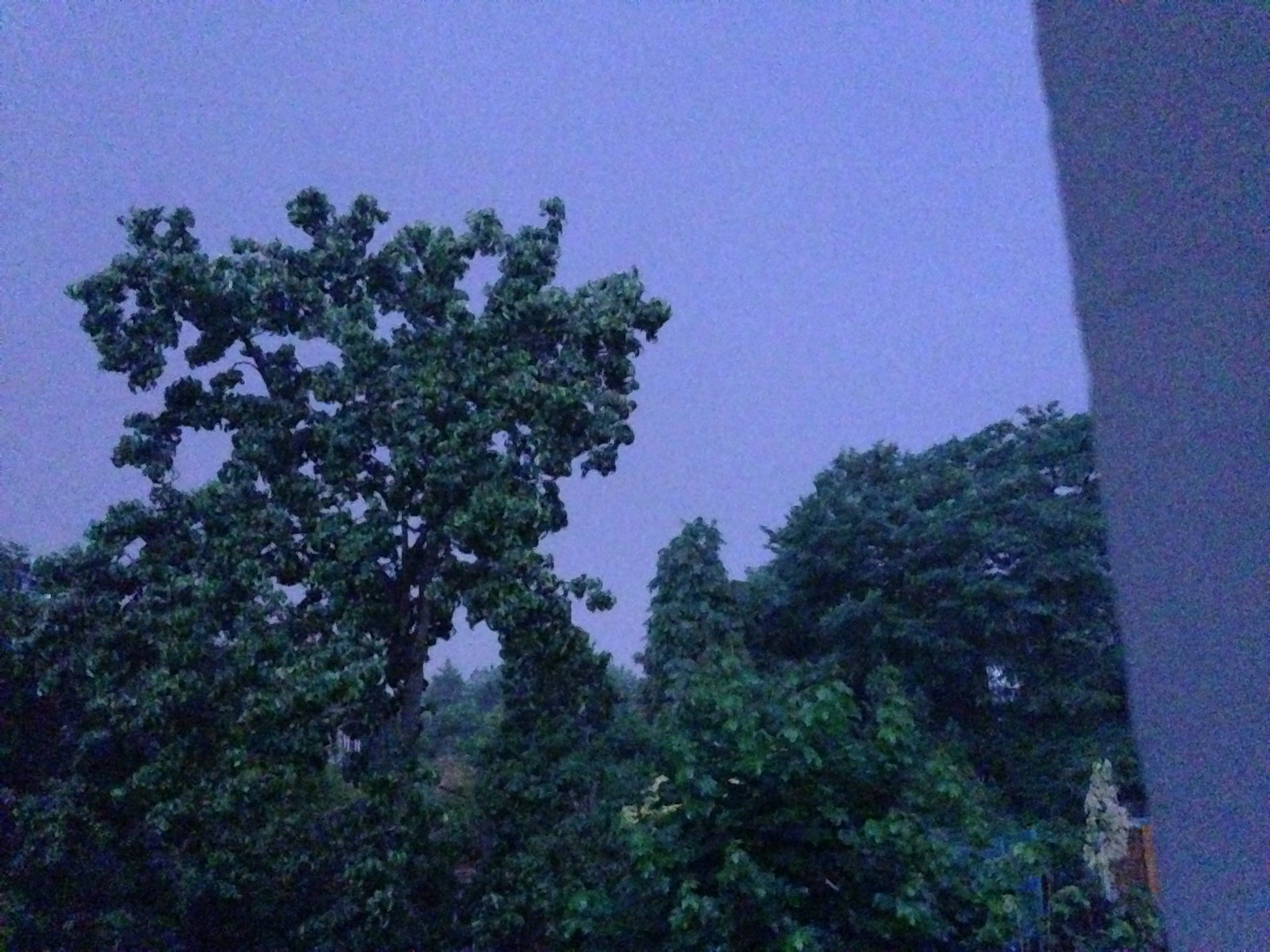
Sunny sunsets were rare in June
7th: Sunny start but cloud rolled in at 1.30pm with thunder heard all around Wanstead. Some serious flash flooding in Croydon. Highest official total was over 40mm in Kenley. Just 1.7mm during the day but trough brought rain at 5am, about 3mm.
8th: Sunny start but felt very humid and oppressive. A thunderstorm skirted Wanstead at 1.40pm with thunder and much rain in Chigwell, not much in Wanstead. More thunder at 2.10pm. Rain came and went for rest of day until 7pm – very little upper air movement. Mostly cloudy overnight.
9th: Cloudy start but some sunny spells developing.
10th: Cloudy start but soon decreased with long sunny spells developing. Lower humidity so felt pleasant.
Heavy rain in Chigwell
11th: Cloudy and humid start with very heavy rain at 3pm. This lasted for 45 minutes. More rain fell sporadically through the day, evening and overnight.
12th: Cloudy after moderate rain. Showers and longer bursts of rain returned before a brief clearance at 3pm. More showers piled in with a real corker to the north of Wanstead.
13th: Damp start soon led to light rain, turning persistant at 11am. Then outbreaks of rain throughout the day, evening and overnight.
14th: Light rain to start but this quickly gave way to heavy showers all day. Some brightness at 6pm then turning drier overnight. Gin clear dawn.
15th: Sunny start but with lots of convective cloud. Some drizzle but a heavy shower stayed to the east of Ilford.
16th: Bright start with sunny spells, more breeze than recent days
17th: Lots of cloud around though sunny spells arrived early afternoon. Then showers between 5 and 6pm.
18th: Cloudy with spots of drizzle. Feeling cold all day – a maximum of only 16.5C.
19th: Sunny start but cloud gradually increasing all afternoon. Rain by nightfall that fell intermittently for hours. Rain again at obs time.
20th: Rain to start that lasted, with variable intensity, through the morning. Sunny spells from mid afternoon.
21st: Sunny start with just a few cirrus and cumulus, this tending to increase through the morning to leave an overcast afternoon. Cloudy overnight – a few spots of drizzle on school run as frontal wave started to move across UK.
22nd: Cloudy start with warm sector drizzle. Showers developed at 11pm, much thunder and lightning and the rain turned really heavy through the early hours.
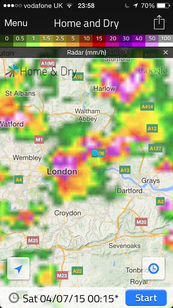
Extremely heavy rainfall during the early hours of the 23rd
23rd: Cloudy and humid to 1pm. Showers at 3pm.
24th: Sunny with variable cloud. Feeling humid in the sunshine.
25th: Bright start with sunny intervals. Light shower at midday. Thunderstorms at 2pm, 4pm and 9.30pm.
26th: Sunny spells though significant cloud at times. Rain between 4 and 6pm.
27th: Mostly cloudy though with some brightness after noon. Warmest point was in the evening at 7pm.
28th: Bright though cloudy start. Some sunny intervals but rain late afternoon into the evening. Cool overnight.
29th: Cloudy and breezy, some rain in the air early afternoon and again in the early hours
30th: Cloudy with slight breeze. Some light rain in the early hours.
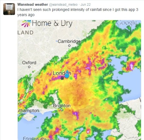
The past week has produced the highest 24-hour rainfall total recorded in Wanstead since at least 1960. The multi-cell thunderstorm on Wednesday night saw 60.8mm fall, most of it in two hours, bringing flash floods to the surrounding area. The spectacular lightning and thunder that accompanied it was almost a side show such was the intensity of the rainfall.
An image from the Home & Dry app revealed a succession of dark red echoes passing over our area. The heaviest rain seemed to run on a line from Battersea to Romford
I was unfortunate enough to be riding home right in the middle of the event: the entire length of the Mile End Road bore a resemblance to a shallow river, the heavy rainfall bouncing back off the Tarmac high enough to create what felt like a powerful drench shower.
The legacy of the downpours caused chaos in the morning and evening rush-hours. Many commuters were stranded at London terminals including Waterloo station because of flooded tracks, possibly robbing many of the chance of voting in the EU referendum. It will never be known if this would have had a bearing on the final result.
Many people think of June as a warm, summery month. The term Flaming June is regarded in most peoples’ subconscious as a reference to past weather. That it is a actually the name of a painting is often missed. Looking back through our local history there has been many notable events of thunderstorms and prolonged rainfall. In 1903 a record-breaking 59-hour deluge left vast swaths of the borough inundated.
The offical UK weather station totals all recorded less than Wanstead
This weekend 200 years ago, during the Year Without a Summer, a powerful tornado, strong enough to carry away objects weighing 60lbs, tore through the Edgware Road area in west London. Luke Howard recorded the event in the Climate of London.
At two o’clock being a still sultry day a whirlwind passed over the nursery ground of Mr Henderson in the Edgware Road which lifted seven lights from the greenhouses and carried them to the height of the highest elm trees, each of the lights weighs 50 or 60lbs at least. At the same time two garden mats were carried to an immense height so that the eye could not distinguish them.
The following day “extremely heavy and prolonged rain from 9am (26th) to 9am on 27th gave 2.95 inches”. This total of over 52mm is notably high though not a record.
This weather was a continuation of what had been an awful May and June – cold with more than twice the average rainfall in June.
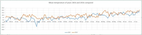
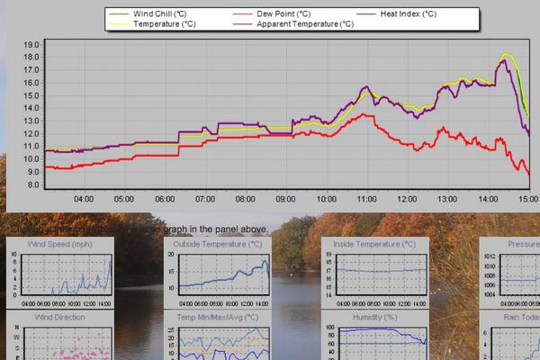
The weather then was not unlike what we have experienced this month. Indeed, a look at the weather throughout this year was similar as this graph shows.
Though the mean temperature at times bears a close resemblance this year is no comparison to 1816: The mean then was running at 6.2C, over 3 degrees colder than today.
Mean pressure was also lower being 992.1mb; the 2016 mean 9am pressure is 1010.6mb.
Perhaps not surprisingly this year’s rainfall actually trumps 200 years ago; the running total for rainfall here is 390.1mm, higher than the 309.6mm recorded in 1816.
The dreary summer and frequent thunderstorms of 1816 inspired Mary Shelley to write Frankenstein. A summer vacation in Switzerland led her to spend much of the time indoors. She, along with Lord Byron and John William Polidori entertained each other with a contest to write the scariest story of all. The unseasonal conditions, along with this dare, led to the creation of Shelley’s Frankenstein: The Modern Prometheus— as well as Polidori’s novella The Vampyre and Byron’s long-form poem, The Darkness.
It will be interesting to see if this June’s weather, along with momentous political changes here and in Europe, produce more fine fiction from the this and the next generation of writers.
Wind speed during the event from 2300 to 1000Temperature during the event from 2300 to 1000Pressure during the event from 2300 to 1000Rainfall from 2300 to 1000Rainfall rate from 2300 to 1000
December 2015 was a ridiculously warm month, the mildest on record in my local series going back to 1797.
The mean temperature of 10.9C is 5.3C above the average for the first winter month and breaks the previous record set in 1974 by an increadible 2.2C.
Indeed the month was warmer than what was a very mild November and was air frost free.
A persistent flow of air from the Azores was responsible for the unseasonal warmth
Sunshine was below average: 34.6hrs (86% of average) was the lowest total recorded since 2010, another December that was as exceptionally cold as this month was mild.
Rainfall was more run-of-the-mill: 44mm fell during the month: that’s 83% of average.
The warmest day occurred on the 19th with 16.3C recorded, the second warmest December day in my daily record going back to 1959 – the record fell short by just 0.1C.
Other daily records were broken including for daily mean temperature: 14.3C on Boxing Day smashed the previous record set on December 4th 1985 by 0.4C. This day also saw the highest daily minimum for December recorded: 13.5C. It was also the warmest Christmas Day on record in a series going back beyond 1852.
The lowest temperature occurred on the 8th when the mercury fell to 2.4C.
The wettest day was on the 3oth when 5.9mm of rain fell. There were only three completely dry days during the month. Thanks to the synoptic situation this area thankfully escaped the awful flooding which affected the north of England and Scotland.
There is quite a marked upward trend in the December mean since 1797
What has January got in store weatherwise? The models today (January 1st) suggest that low pressure will continue to pile into the UK from the west on quite southerly latitudes over the next week with some colder air infiltrating into the east and north of the UK from Europe with rain at times for our area. From that point on most output suggests largely unsettled weather continuing until the end of the two week period though there is a hint that high pressure may try to edge up from the SW or west later with less wind and rain but still mild.
Because of the exceptionally mild December there are virtually no figures I can work with to try to estimate January – but I’ll have a crack anyway, using figures that were at least 1C above the 1981-2010 December average.
A mean of about 5.2C with 59mm of rain, both around average. The highest probability is for average temps at 33% probability. Interestingly something ‘very cold’ comes in at the same probability. Rather mild and rather cold come in at 16% probability. I emphasise that even at such low probability my confidence is even lower.
My December outlook for temperature was way off – there was no chance shown of anything ‘very mild’.
Here follows the full weather diary for November. To view full stats follow this link:http://1drv.ms/1kiTuzv
1st: A few spots of rain after deluge overnight then cloudy.
2nd: Cloudy to start, some sun mid morning before it clouded over with two spots of rain. Mild overnight.
3rd: Cloudy start with little brightness all day. Rain moving in at 7.15pm and intermittent into the evening, clearing later with temp falling from midnight.
4th: Sunny, clear start, tending to cloud over at 11am with limited brightness.
5th Cloudy and windy all day – the wind peaking at 9pm but remaining fresh through the night.
6th: Cloudy and dull most of the day.
7th: Cloudy start with some light drizzle mid morning.
8th: Dull, drizzly start with steadier bursts. Heavy rain as front cleared through at 2pm. Evening and overnight much colder than of late.
9th: Sunny start, clouded over afternoon.
10th Cloudy start and through the day. Rain spreading in in the evening, clearing by midnight.
11th: Cloudy through the day until 2pm when a narrow band of rain passed through then dry and feeling cooler.
12th: Cloudy start with some drizzle around 10am.
13th: Cloudy and drizzly to start then just cloudy.
14th: Cloudy start with some brightness at noon. Cloudy into the afternoon with some drizzle overnight.
15th: Cloudy and dull. Rain later in the evening.
16th: Cloudy with two sunny intervals then cloudy with odd drizzle.
17th: Cloudy with odd brightness then rain at 5pm.
18th: Cloudy all day.
19th: Bright and breezy start.
20th: Dull start with heavy rain at 3.40pm. Then cloudy but clear by morning.
21st: Sunny start but quickly clouded over with rain.
22nd: Dull start with patchy drizzle up to 11.30am. More rain later with squall at 8pm.
23rd: Sunny start with cloud moving in then sunny spells.
24th: Sunny start quickly turned cloudy with heavy rain around noon, clearing to sunny spells.
25th: Cloudy start with light rain spreading in at 10.10am. Cloudy rest of afternoon with temperature climbing through the day for record warm Christmas day. Temp didn’t fall below 14C all night.
26th: Cloudy and warm all day. Temp fell to just 13.9C though the day then rose again to give the warmest December night on record, and also warmest December mean.
27th: Dull with brief burst of drizzle early then breezy and very mild. Clearer overnight and cooler than of late. Sunny start with pink clouds am.
28th: Sunny start with just a few cirrus. Mostly sunny through the day.
29th: Sunny start with brief heavy shower at 10.05am. Then sunny intervals.
30th Cloudy and breezy to start. Rain spreading in in the evening, stopping around midnight
31st: Sunny and clear to start but with cloud bubbling up from late morning. Brief rain after dark then dry and turning colder. Frost in early hours of 1st
The race to build more riverside property on London’s floodplain has received another boost after a big development on the Greenwich Peninsula was given the green light.
The Environment Agency’s Flood Plan map of the Thames
The Financial Times reported on Friday that Boris Johnson has given final approval to an £8.4bn, 12,700-home development that would transform this area of south-east London into a “high-rise urban village complete with film studio”.
Knight Dragon have already begun construction on the project, a 150-acre scheme approved 10 years ago in a more modest form but revived and expanded after the financial crisis.
The report mentions that local residents are concerned the scheme will place unbearable strain on the area’s transport links and that the size and density is out of keeping with Greenwich’s World Heritage Site of 17th to 19th-century buildings close by.
What is not mentioned is flood risk – a factor that, considering climate models, is deemed too minuscule to worry about. The proposed development satisfies this risk criteria – a report on the ‘Strategic Flood Risk Assessment’, drawn up in October 2011, mentions:
“Tidal flood risk is extensive, but at present Greenwich is fully defended against the 0.1% annual probability extreme tide level with climate change to 2107. A breach in the defences, although a low probability of occurrence, would have a high consequence, causing significant flooding of the Thamesmead, New Charlton and Greenwich Peninsula areas of the Borough.”
But is it wise to build on historic floodplain? Surely we should be looking elsewhere in London for safer sites for projects that will help ease the housing crisis.
The website floodlondon.com shares concern that developments such as these are at severe risk from a tidal surge when the Thames Flood Barrier nears the end of its working life in the middle of this century.
“Perched on the very tip of the Greenwich Peninsula, the O2 Arena finds itself ideally located on a nice sharp bend in the river where it is likely to take the full brunt of the surge as it careers into the bank, much like a racing car taking a corner too fast. The North Greenwich tube station just across the road will prove to be a great asset at this point as it funnels the water into the Jubilee Line.”
Before the Thames Barrier was built this part of the river has seen some catastrophic flooding.
The 1875 flood as reported in the Morning Post
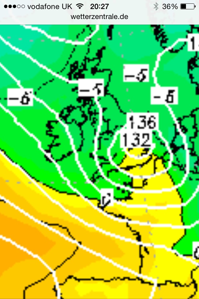
In November 1875, a year that was only slightly wetter than normal, a record high tide of 8.9m was recorded at Blackwall. The figure is 1.36m (4ft 6in) higher than the greatest high tide at North Woolwich (Silvertown) this year, according to tide tables drawn up by the Port of London Authority (7.54m on March 20th).
The flood brought chaos throughout London – with this part of the river particularly badly hit. Much of the Isle of Dogs was inundated, North Woolwich Gardens were under 3ft (1m) of water while the water caused explosions at the Royal Arsenal. Elsewhere in the capital Eton College was ‘completely surrounded by water’. A correspondent for the Press Association said the damage caused on the banks of the Thames was estimated to cost £1m sterling – just over £103m at today’s prices.
The Sunderland Daily Echo & Shipping Gazette on Tuesday, November 16, 1875 reported a depth of water at East India Docks of 29ft 2in. Damage was estimated to be £1m sterling – just over £103m at today’s prices.
Since the flood of 1953 measures, including the Thames Barrier, were put in place to stop this flooding. The Environment Agency has outlined a range of options for the future of the Thames Estuary flood defences. None are particularly cheap. As a minimum, the EA estimates that the cost of maintaining the defences until 2035 will be around £1.5 billion, with an additional £1.8 billion needed to repair and upgrade the defences until 2050. Particular bits of marshland could also be set aside to store tide waters.
The EA estimates a new barrier could cost as much as £7 billion, though that figure could go up if conditions change significantly as the climate changes.
Greenwich Peninsula and another project, City in the East, which was announced last month will need proper flood protection and planning. I wonder if planners are as willing to invest in these defences as they are at making a tidy buck developing these riverside schemes. And do our politicians have the appetite to drive the legislation through?
The problem is that if the climate change does bring greater rainfall and an unprecedented sea-level rise it is the people living in these properties that will be faced with the problem of ever-increasing costs to fight off the risk of inundation.
Legend has it that the weather on St Swithin’s will be the same for the next 40 days.
St Swithin’s day, if thou dost rain,
For forty days it will remain;
St Swithin’s day, if thou be fair,
For forty days ’twill rain na mair.
St Swithin’s Day is probably among the most well known of weather folklore – but, taken at face value, it is probably the most unreliable.
Grasslands around Wanstead Park have gradually turned brown because of the lack of rainfall since March
Since 1848 Wanstead and the surrounding region has enjoyed 93 dry St Swithin’s Days (56%). From these the longest dry spell that followed was just 18 days, in 2000. On average, if St Swithin’s is dry, the weather stays fair for 3 days, with rain arriving on the 18th. Many dry St Swithin’s Days (17%) are followed by rain the next day – these results skew the median for rain after a dry St Swithin’s to just 2 days!
Another interesting observation is that the 40-day period that followed a dry St Swithin’s is on average 13% WETTER than if it rained on July 15th.
So what does this mean for the rest of July and the summer? Looking back at other years that have seen a mostly dry and warm pattern in the run up to St Swithin’s Day we should see a continuation of frequently dry, warm and sunny conditions, interspersed with rainy days and, perhaps, thundery breakdowns. A typical British summer!
Putting superstition and singularities aside current weather models back this up.
St Swithin’s reputation as a weather saint is said to have arisen from the translation of his body from a lowly grave to its golden shrine within Winchester cathedral, having been delayed by incessant rain for 40 days
St Swithin was born around 800AD and died on July 2, 862, at Winchester, Hampshire. According to historians he was fond of building churches in places where there were none. St Swithin, who was bishop of Winchester, was buried in the churchyard of the Old Minster at Winchester, where passers by might tread on his grave and where the rain from the eaves might fall on it.
His reputation as a weather saint is said to have arisen from the translation of his body from this lowly grave to its golden shrine within the cathedral, having been delayed by incessant rain for 40 days.
The basis of the St Swithin’s saying follows the fact that by July 15th summer weather patterns are already well established and tend to persist through the coming weeks.
In meterological terms the position of the frontal zone around the end of June to early July, indicated by the position of the jet stream, determines the general weather patterns (hot, cold, dry, wet) for the rest of the summer. Like a little stream in its bed, the frontal zone tends to ‘dig in’ shortly after the summer solstice.
As the path of our weather systems is controlled by the jet stream, a more southerly location of the frontal zone – as happened last year – is likely to bring unsettled, wet and cool weather. On the other hand, a frontal zone shifted further to the north – as is happening this year – will help the Azores high to build over western Europe, thus bringing dry and pleasant weather to the UK.
Other western European countries also have similar St Swithin’s day sayings – that follow the principle rule. In France they say ‘Quand il pleut a la Saint Gervais Il pleut quarante jours apres’ – If it rains on St. Gervais’ day (July 19th), it will rain for fourty days afterward.
In Germany the Siebenschlaefer or seven sleepers day (July 7th, after the Gregorian calendar) refers to the weather patterns of the following seven weeks.
If you like thunderstorms Wanstead seems to be leading something of a charmed life these past couple of years.
The storm at 23:43
Two years ago I wrote a blog asking what had happened to decent summer thunderstorms that were so common during my youth in the 1980s. Last night was the fourth time Wanstead has experienced a really good light show, complete with multiple lightning strikes and Hammer Horror-esque thunderclaps. The first storm passed over at 23:43, delivering 3.7mm rain at a rate of 20mm/hr. Another followed shortly after at 23:58, a pressure trace revealed a 1mb fall as the storm passed through. Nothing special as I have seen a 6mb drop in similar circumstances. By this time the sky was alive with lightning – yet again I failed to capture any lightning bolt but did manage to photograph my garden at the moment night became day – the world’s most powerful flashgun!
The radar picture of the storm at 23:58What would you give for a flashgun this powerful? The storm at its peak at 00:22
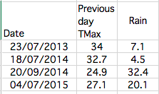
At 00:19pm occurred the brightest flash of lightning almost instantly followed by a very loud crack of thunder, the kind you hear on those Hammer Horror films with Peter Cushing. Looking at the rainfall of weather stations around the south-east it appears that Wanstead was in the thick of the action, clocking up 20.1mm of rain and second only to Bedford. The amount represents 47% of what normally falls in an average July. As always in these situations some places get a deluge while others remain almost dry.
There was 112,833 lightning strikes across UK & Ireland between 9pm and 9am on July 4th Image courtesy of Blitzortung
Looking further afield around London an observer in Blackheath reported an hour to 90 minutes of ‘roaringly good storminess’ that brought a house party to an abrupt end. He counted 15 flashes of lightning a minute, lots of CC but a few CGs too, including one close as the storm kicked off.
Elsewhere an observer in Highams Park reported 30 flashes per minute. In Dorset another observer 50mm of rain, most of which fell in an hour. The storm that tracked over the Salisbury region had what seemed like 3x the lightning of the storms in the SE corner.
Forecasting of the event was handled better by some agencies than others. For location accuracy the MeteoGroup discussion had an edge over the Met Office.
The Trappes (Paris) ‘loaded gun’ ascent for July 3 can be found here – warm / dry layers between 900 and 800 hPa and ~2000 J/kg of CAPE, with high CAPE values expanding aerially as the trough neared. Approach of the trough caused cooling aloft – not sufficient for the capping inversion to break around Paris itself but farther west and north.
Lightning streamers were visible moments before each thunderbolt. These come out of the ground to meet the main bolt – a sure sign that Wanstead was right underneath a cellA pressure trace at 11am on July 4th shows the peaks and troughs during the stormThis table shows the most notable thunderstorms that have passed over Wanstead during the past two years
June finished hot in complete contrast to the opening few days which were a continuation of a disappointing May.
There were six occasions when the maximum exceeded 25C – the highest being 30.8C on 30th, the warmest June day for four years.
Mean temperature for the month was 16.9C, 0.8C above the 1981-2010 mean. Rainfall of 17.5mm was 34% of average – the last three Junes have been notably dry.
There were 189.5 hours of sunshine recorded in this area which is 106% of what we can expect to see during an average June. The wettest day occurred on the 20th with 11.1mm. There were two days of thunder recorded.
So what has July got in store weatherwise? The models this morning (July 1st) suggest a battleground between Atlantic cooler air and hot continental air, a common feature at this time of year. The persistent heat on the continent looks like it will waft back and forth across the south-east – creating the risk of thundery downpours as it meets resistance from successive cold fronts.
Just 17.5mm of rain fell in June – 34% of average
The model output suggests the Atlantic air will eventually win through, allowing more changeable conditions in a week’s time. There is also a signal that high pressure will re-establish with a return to fine and very warm weather. As things stand the models remain finely balanced.
In contrast to the models my long range method suggests overwhelmingly that we are in for a warm July, up to 1.7C above average, at 60% probability
The next highest chance is for rather warm at 40% probability. If you add the probabilities together the chance of a rather warm to warm July can be put at 100% – perhaps a repeat of last year’s and 2013’s classic July is about to unfold?
Rainfall is looking below average, at 60% probability. There’s obviously a risk here that a couple of direct hits from thunderstorms would see the monthly total exceeded. I don’t have enough data to estimate sunshine but I would guess average to slightly above.
My June outlook was only good in that it ruled out any chance of a very warm month – the final mean was rather higher than I thought. I was also out with the very low rainfall – the signal was for something average. Sunshine was broadly average as I’d estimated
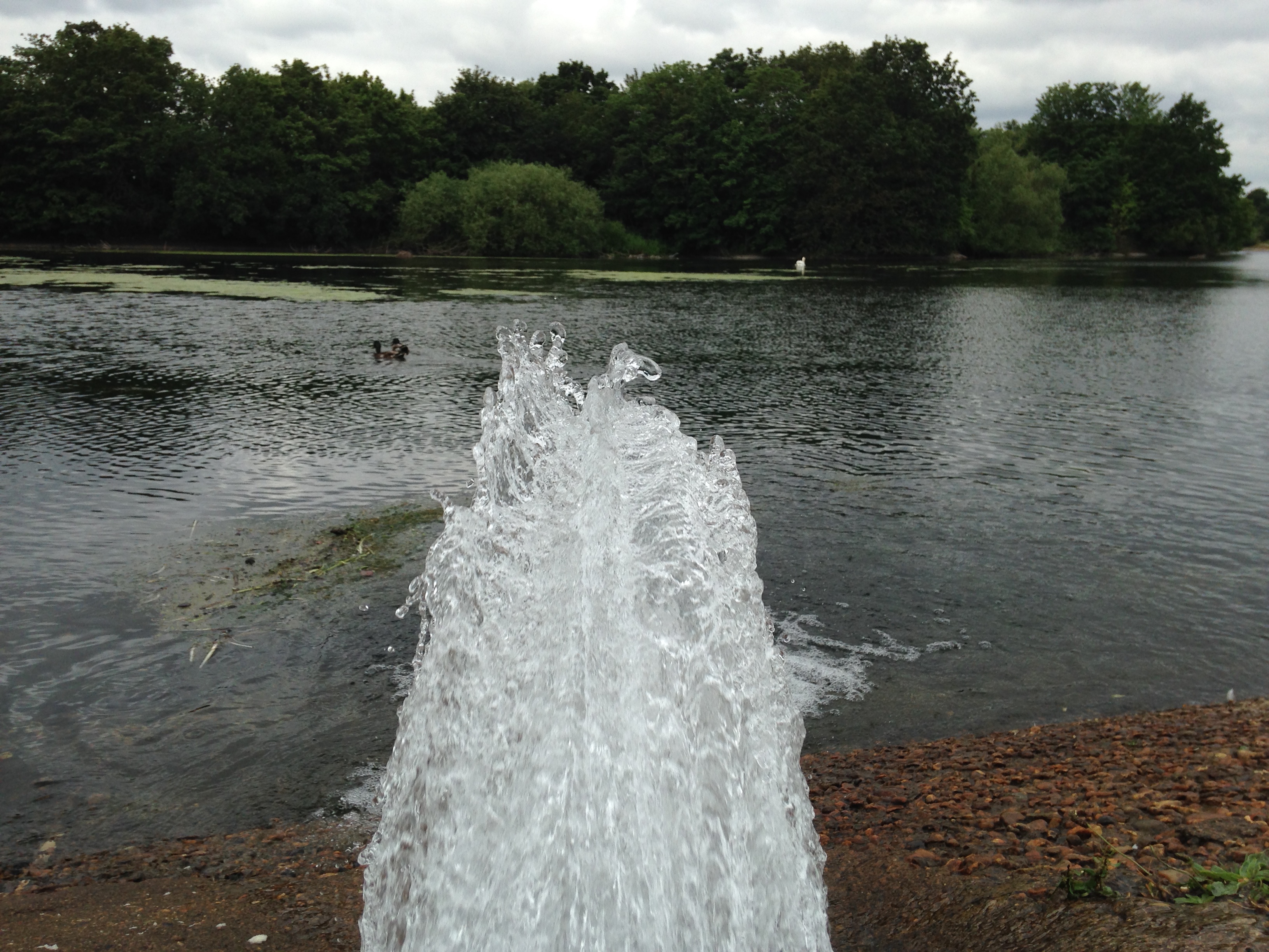
The Heronry Pond in Wanstead Park is suffering from low water levels again
1st Sunny, bright start quickly turned cloudy with intermittent drizzle through the day. Turned windy at 6pm and was really blowing around midnight.
2nd Drizzle in the wind at obs time and very windy, wind only decreasing by evening. A dreadful day though warm.
3rd Sunny start though cloud gradually increased. Feeling humid and summery at last.
4th Sunny start with cloud dotted with alto cumulus and cirrus. Rain between 5am and 6am – though storms passed to our west and east.
5th Bright start after earlier rain – the thunderstorms seemed to pass to our west and east. Very humid and felt oppresive in the morning.
6th Sunny start with cloud bubbling up. Much cooler and fresher feel. Lots of long sunny spells.
7th Sunny, gin clear start. Just a few fair weather cumulus all day. Gorgeous.
8th Bright start though alto cumulus shaded early sun. Variable cumulus after that – feeling chilly.
9th Cloudy and brisk wind from NE. Feeling chilly.
10th Bright start with sunny intervals throughout the day.
11th Sunny start with few cirrus, sky then completely cleared.
12th Sunny start though cloud bubbled up through the day – felt very close at sports day. Distant thunder heard at 8pm with light rain – much less than was threatened.
13th Cloudy start, mostly calm, still and dull – a real nothing day though some late brightness after 2pm pushed up the temperature briefly. Mild overnight with some light drizzle before obs time.
14th Drizzle in the wind up until 11pm and falling temp. Then a brief sunny interlude before it was cloudy again.
15th Cloudy start then briefly clearing before, at 1pm, more cloud appeared. Clear overnight allowing temp to fall until 4.10am but clouding over by morning – bright warm sunshine at 9am.
16th Sunny start but very cloudy at times. This continued all day – though the night was cloudier hence warmer.
17th Sunny start but with lots of cloud around.
18th Lots of long suuny spells but cooler than yesterday.
19th Cloudy up until 11.30pm and cooler. Broke to sunny spells and much warmer at 2pm.
20th Bright start though warm from started pushing through just before 1pm. Some sunny breaks but rain pushed in. Was in Cheltenham but Woodford Wells reported thunder: Between 1650and 1730 12mm fell followed by a decreasing amount of 2.4mm up to 1814 all BST Two thunder claps at 1715 and 1728.
21st In Cheltenham it was a mostly cloudy day though with more sunny intervals after midday. Rain spread in just before midnight with more in the early hours.
22nd Cloudy start though with brief sunny break at 10am. Some drizzle 11.15am then drier with sunny intervals.
23rd Bright start. Cloud broke to give warm sunny spells .
24th Sunny periods after a rather cloudy start. Felt very warm in the sun during walk around London with Neil and family.
25th Sunny start though hazy cloud developed from 10.30am, rather obscuring the sun at times, though it was bright all day. 26th Warm till late into the evening – still 18C at 11pm.
26th Bright start though cloudy, broke to sunny spells and felt warmer than forecast.
27th Sunny start though with cloudier spells all through the day. A very warm evening.
28th Sunny start quickly became cloudy with rain turning up at noon during early lunch. This later cleared to sunny spells and a pleasant afternoon.
29th Sunny start though with high cloud obscuring the sun at times.
30th Sunny, gin clear all day. only ‘cloud’ was distant grass fire.
The 30th was wall-to-wall sunshine until late in the evening when alto-cumulus and cumulus were observed
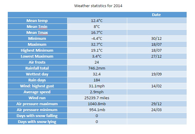
This year finished as the second warmest year on record after 2011.
Every month of 2014, apart from August and December, was warmer than average – the means being over 1C warmer every month, bringing the mean temperature to 12.4C, just 0.4C short of the warmest year in 2011 and 1.2C warmer than the 1981-2010 average.
The number of days with thunder was also high. Thunder has been heard in Wanstead on 19 days. In an average year we can expect thunder on only 12 days.
Rainfall is less remarkable although the year has certainly been wetter than average. The total of 746mm puts it in the top 20 per cent of years for rainfall since 1797.
There was occasional respite from the persistent rain
The year began where 2013 left of: wet. Depressions whistling in off the Atlantic brought incessant rain and the wettest January for 130 years. The total, 131mm, which was 2.5 times the average for January, beat the previous record set in 1988 by just 2.8mm. Unlike 1988, January followed a December that was 1.5 times wetter than average – a wet spell that impacted the river Roding where levels ran high.
The most notable day was probably Saturday 25th when what started as a bright, fine day quickly changed around 4pm as a strong squall with heavy rain blew through with associated thunder and lightning and 6C fall in temperature in an hour.
The warm January was followed by an even warmer February with a complete absence of air frost – very unusual for what is commonly the coldest winter month. The conveyor belt of storms off the Atlantic also calmed though not before a storm on the evening of Valentine’s Day saw yet more damage, resulting in two deaths, including a man killed by a wave on a cruise ship in the Channel and a woman killed when a block of falling masonry crushed her car outside Holborn Tube station. The sheer quantity of rain also brought flooding problems around the area. It was also the first winter ever where no snow falling or lying was observed.
The water table appeared to come to the surface on Wanstead Flats in February
The warmest March for 74 years brought lots of gloriously sunny days, a welcome relief from the run of seemingly endless wet months. Just 25.8mm of rain fell over the 31 days – that’s 63 per cent of average. The most notable weather occurred on the 26th when the temperature fell from 10C at 1.30pm to 4C by 3pm. Heavy showers accompanied what was an utterly foul day. The cold pool persisted into the 27th with towering thunder clouds surrounding Wanstead, north, east and south.
The month ended with warm, sunny weather – the southerly flow bringing Saharan dust that deposited on cars.
April continued this year’s theme of being milder than normal; the mean temperature of 12C was 2.2C above average, making it the third warmest April since 1797.
April continued the dry theme of March. Just 19.6mm on rain fell over the 30 days – that’s 46 per cent of average.
The month saw some stunningly sunny days during the second week into the third week, though these were tempered by chilly east to north-easterly winds. The warmest day was the 21st when 21.5C was reached – the first ^70F temperature of the year.
May was also mild though the rain returned with 71mm falling – 139 per cent of average – this hindered sunshine totals to 157 hours, the dullest for 10 years. Most notable was the number of thunderstorms with four incidents of daily thunder.
This screen grab shows the thunderstorm at 4pm on May 24th that saw the temperature fall nearly 6C in a matter of minutes
Though it began unsettled June became warm and dry. Just 15.2mm of rain made it the driest since 2000. The month also brought some spectacular cloudscapes thanks to the high level of thundery activity elsewhere. Though Wanstead did not hear thunder there was plenty of activity close by. It is a typical feature of summer that rainfall can vary a great deal across a small area. The nearest official station to Wanstead, St James’s Park 8.4 miles to our south-west, recorded 33.8mm – more than double what fell here.
June was marked by some spectacular cloudscapes and sunsets. This was the view across Wanstead Flats from Centre Road looking toward Ilford on the 21st
Yet another occasion of impressive cloud formation during June included this example of late evening cirrus. The formation, seen at ground level, seemed similar to a display of the Aurora.
July brought perhaps the most spectacular of our weather. A heatwave brought much thundery activity in what was the 9th warmest July since 1797.
The month was marked with spectacular thunderstorms and torrential downpours, contributing to what was a much wetter than average month – some 73mm fell which is 168% of the monthly average. While on paper the month looks very wet it should be noted that 52% of the July total fell in two episodes: a stalling warm front on the 10th and a cloudburst on 25th. I was away for the thunderstorm though a friend remarked that the roads close to Redbridge Roundabout were like torrents, the rain was so intense for a short period.
The hottest day in July and the year was the 18th with 32.7C recorded. There were 12 occasions where the mercury reached or exceeded 80F.
Perhaps the most impressive thunderstorm was the development of the MCS that moved up from France during the evening of July 18th. There were numerous superb pictures but my favourite is probably this shot taken by Richard Dixon.
This shot was taken by Richard Dixon in Whitstable, Kent. It shows, perfectly, the contrast betweeen the bright orange sunset and the impending doom of the approaching MCS from the continent
What had been a superb summer abruptly ended in August which ended cool, wet and dull. The month, the only one this year that was cooler than average, was characterised by frequent rain and the coldest August night for over 20 years.
More thunderstorms also made it a wetter than average month – some 76mm fell which is 152% of the monthly average and the wettest for 4 years. A couple of nights were notably cool for August: 5C was recorded during the early hours of the 23rd – the coldest August night since 1993.
It was yet another month where rainfall totals could vary greatly in the space of just a few miles. On the 9th a station in Woodford Green recorded 24.4mm, double what fell in Wanstead. The legacy of TS Bertha coincided with the end of our extended hot spell
On 25th a perfect curl could be seen on a depression centred off the west coast of Ireland. The rain associated with this low pressure brought the month’s highest daily rainfall total: 23.4mm (the system bringing 27.5mm) – a thoroughly miserable Bank Holiday Monday where it rained ALL day, from 6am until 9.30pm. It was yet another example of how much even frontal rainfall can vary over a small area with St James Park recording 38.2mm.
Sunset overlooking Wanstead Flats 2nd August
In terms of weather events September was a warm and relatively quiet month save for the two thunderstorms that seemed to mark the Scottish Referendum as the results became apparent in the early hours of Friday 19th. The most notable storm happened around 3pm which brought 24.5mm of rain with a peak rate of 76.5mm/hr at 15.47. The storm ended a run of 16 dry days. Explosive convection brought hail and rain and flooding to Hackney, Hackney Wick and Leytonstone. This storm was the result of a convergence line over London between light southerlies to the south and easterlies to the north – the heavy rain was very localised.
The month was marked with lots of dry, sunny days, the two thunderstorms on the 19th contributing 89 per cent of the rainfall for the month. It was dryer than average – the 44.8mm that fell is 86 per cent of what we would expect in a normal September. Despite this it was only the driest September here since 2011.
Save for the warmest Hallowe’en on record and a notable depression on the 21st October was a relatively quiet month.
The dry and sunny start was replaced with a very unsettled regime at the end of the first week which lasted until the end of the second week – with 39.5mm of rain falling over the 12th and 13th, a notable total for this region. It was wetter than average: 82.4mm represents 123 per cent of what we’d expect to fall in a normal October. The warmest day occurred on the 31st with 21.5C recorded. Many nights were warm with date records matched or broken. Cold nights, relative to the time of year were few.
The final month of autumn was most notable for its rainfall with 19 consecutive days of measurable precipitation and just four completely dry days .
November 22nd by Perch Pond. Drizzle early morning couple with damp air left mist floating above the surface
November was warmer than average; the mean temperature of 8.9C was 0.9C above average, making it the 19th warmest November since 1797: 2.2C warmer than last November, though only the warmest since 2011.
The sunny and warm start on the 1st was quickly replaced with an unsettled, cooler regime week which lasted for nearly three weeks. A brief respite on the 20th was followed by more rain – with 12mm and 15.2mm on the 22nd and 23rd. It was wetter than average: 97.5mm represents 165 per cent of what we’d expect to fall in a normal November.
Despite it being wet it was only the 40th wettest November in the series back to 1797.
The warmest day occurred on the 1st with 17.2C recorded. The first frosts of autumn were recorded. The lowest temperature occurred on 24th when the mercury fell to -1.5C.
Sunshine was average with 60.5 hours recorded – that’s 103 per cent of mean. The sunniest day was on the 4th when 6 hours of sunshine were recorded.
It was the sunniest December on record in the series going back to 1979. Some 11 mornings were completely clear at the 9am observation time
This December was the sunniest on record in my series going back to 1877. Over 90 hours of sunshine were recorded in this area which is 224% of what we can expect to see during an average December.
Mean temperature for the month was average at 5.8C (0.2C above the 30-year average). Rainfall of 39.9mm was 75% of average – the driest since 2010.
The month was 0.7C cooler than last December – with just under half the rain that fell in that wet and stormy month.
December was warmer than average with a mean temperature of 6.5C (0.9C above the 30-year average) – ranking it 33rd in the series since 1881. Rainfall of 81.9mm was 154% of average – ranking it 22nd in the series.
The month was 1C warmer than last December – with 84% of the rain that fell in December 2012.
The first day of December was cloudy, dull and dreary with drizzle in a keen east wind. The following days alternated between rain and sun and some night frost. On the 6th the day started sunny with just a few cirrus clouds – overnight frost persisted all day in garden with a grass min at -2C. The 9th began sunny after a hard frost but then the temperature climbed for 19 hours with cloud building and brief rain at 2am before the cold front passed.
Boxing Day was cloudy and cold before rain, with snow in the north, spread in in the evening. A cold front whistled through about 12.40am on the 27th but not before the warm sector raised the temperature to 8.9C
The wettest day occurred on the 11th. The day started sunny but blustery showers blown in on strong WSW winds coupled together with 6 hours of rain overnight produced 11.5mm.
Things turned much milder in the 3rd week with frequent, chiefly light rain, abundant sunshine and an absence of frost. On the 18th the temperature reached 14C.
Christmas Eve saw the weather begin to cool down again with progressively colder nights. Boxing Day was a cloudy, cold day with rain spreading in during the evening and a notable warm sector raising the temperature to nearly 9C at midnight. The first lowland snow of the winter was reported up north. The month ended with long sunny days and sharp frosts, a couple persisting through the day.


 Beyond the grasp of the models my long range outlook method is again hampered by a very dry August. However, the data I do have suggests an average month at 100 per cent probability.
 My August outlook for temperature was good. I predicted a mean of 19C (outcome: 19.5C). It was drier than I thought: 30.3mm (outcome: 11.9mm). Sunshine was poor: 239 hours (outcome: 192 hours).


 My July outlook for temperature was good. I predicted a mean of 18.8C (outcome: 19.5C). Rainfall was very poor: 50mm (outcome: 17.3mm). Sunshine not badr: 171.9 hours (outcome: 190 hours).


 actually trumps 200 years ago; the running total for rainfall here is 390.1mm, higher than the 309.6mm recorded in 1816.


 Other daily records were broken including for daily mean temperature: 14.3C on Boxing Day smashed the previous record set on December 4th 1985 by 0.4C. This day also saw the highest daily minimum for December recorded: 13.5C.
  The lowest temperature occurred on the 8th when the mercury fell to 2.4C.


You must be logged in to post a comment.