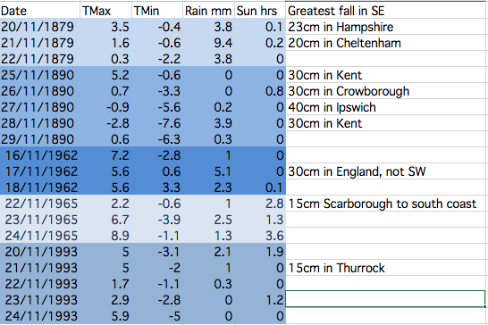
This table shows the stats for Greenwich during spells when there has been heavy snowfall somewhere in the south-east. The figures reveal that it is very hit and miss and that the associated air doesn’t stay cold for long. There is a link to UK-wide November snowfalls here: http://1drv.ms/1PjOB9H
November has produced some potent snowfalls in Scotland and northern England over the past 150 years. These brief shots of cold air, often direct from the North Pole, however very rarely produce anything that can sustain long-lasting low-level snow in London and the Home Counties.
With the GFS weather model occasionally hinting at a blast of polar maritime air I decided to have a look back through the records to see how frequently the capital has turned white during the eleventh month.
Anyone who is familiar with the Objective Lamb Weather Type (LWT) data series will know that there may be an increased likelihood of things turning colder at some point this month. Last month was the joint 5th most anticyclonic October in the LWT series data series that runs from 1871; resulting stats closely resemble both October 1946 and 1962 as being very anticyclonic. Another similar year is 1972.
November 1972 was mild till mid month and then turned much colder with snow in places. November 1962 was cyclonic till the 24th, and then anticyclonic, with a cold northerly outbreak from the 18th for a few days with snow, before turning rather mild. November 1946 in complete contrast to both years, was a mild, dull and very wet month.
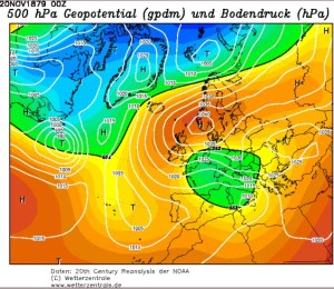
The most impressive November snowy spells seem to have occurred in the late 1800s. These two 500mb reanalysis charts show a cold feed from Scandinavia in both cases.
Snow and sleet falling in the London area is obviously much more common than snow lying. The snowiest Novembers were in 1919 and 1952 when snow or sleet fell for 10 days at Wallington and Hampstead respectively.
Kew saw snow or sleet on 8 days in 1919, while Heathrow and Northolt recorded snow or sleet on eight days in 1952.
This small article appeared on the front page of Reynold’s Newspaper in November 1890
The only decent snowfall that occured in London in my lifetime was November 1993 – and I was abroad for that. I remember my dad mentioning it in a letter written to me as I travelled round China. It arrived in the early hours of one Sunday morning and fell to a depth of five inches.
Given that was the last time London saw a decent fall I won’t be holding my breath that we’ll see any this month – though, if you live in Scotland, the odds are much narrower.
Before 1861 information on snowfalls becomes scarce – at least in terms of correct quantity. However, heavy snowfalls obviously did occur. On November 17, 1816, the Inverness Journal contained this report:
“The winter has commenced with a severity almost beyond example. Frost, rain and snow have been almost incessant during the last week and the greater proportion of corn still uncut or in stocks has suffered material injury.
“We regret to say that several lives have been lost. A postboy of Bennet’s coming from the south was obliged to leave his chaise on the road and would have been lost but for the lights shown from the windows of Moyhall which he reached nearly in a frozen state. The obvious advantage of keeping lights in stormy nights in the windows of houses in the country has thus been illustrated
“The winter it appears has set in with extreme severity in the interior of the continent. At Augsburg on the 19th of November the eclipse of the sun was entirely obscured by a fall of snow which commenced at 7 o’clock in the morning and lasted till noon. The ground was covered with snow a foot in depth. There was a great fall of snow at Frankfurt on the same day and Reaumur’s thermometer showed at from 9 to 10 degrees below the freezing point.”
Perhaps the most impressive, modern day snowfall in the south of the UK occurred around November 18th 1972 when observers recorded 60cm of snow on Dartmoor. Synoptic charts and other data are attached below.
Image courtesy of the Met Office
Image courtesy of the Met Office
Image courtesy of the Met Office
Image courtesy of the Met Office
Inspiration for this piece came from Dr Richard Wild’s PhD study on snowfall which you can find here.
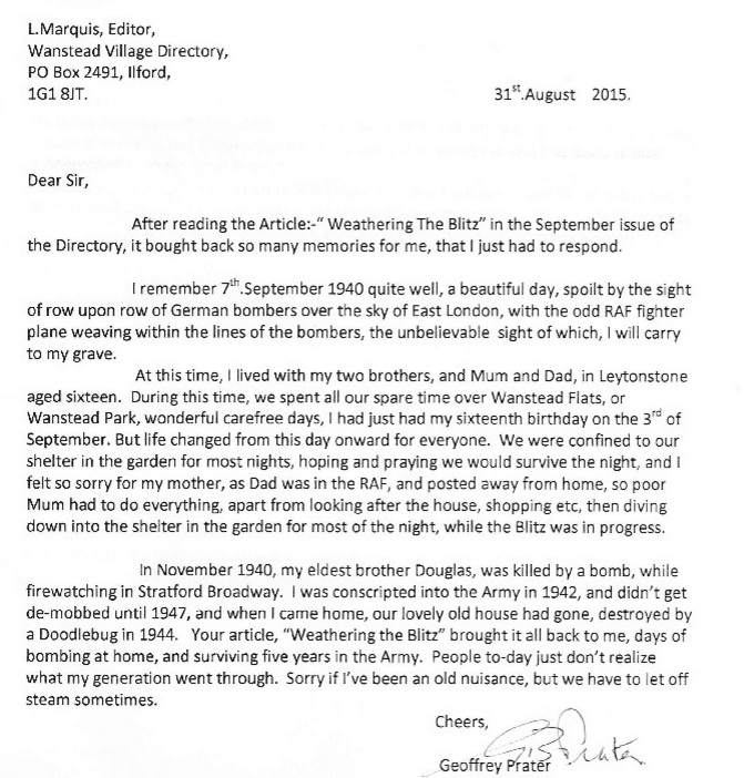
Geoffrey Prater served in the 51st Royal Tank Regiment during his five years’ national service and saw action during World War II in Italy and North Africa.
I met the 91-year-old Wanstead resident earlier this year after my article on the Blitz prompted him to write to the editor explaining what life was like during the war 75 years ago.
Over a cuppa we spoke at length of how he and his family coped with the Blitz. Carefree days spent playing over Wanstead Park and Wanstead Flats were brought to an end in September 1940 as the Luftwaffe’s bombs started to rain down. In November 1940 Geoff lost his elder brother, Doug, during an air raid in Stratford.
He was called up for national service in September 1942 and, after a year of training at Brentwood, Farnborough and Barnard Castle, his regiment set sail from Liverpool docks in December 1943. Five days on mountainous seas, through the Bay of Biscay, ended with arrival in north Africa on Christmas Day from where he was posted to Italy to fight the Axis.
On returning from Italy Geoff had to come to terms with the fact that his family home in Devonshire Road, Leytonstone, had been destroyed by a V1 doodlebug bomb. His mum and younger brother, Dunc, who only narrowly escaped the bomb, had to move to a flat above a shop in Chobham Road, Stratford.
Geoff has written an account of his experiences during World War II. It’s an absolutely fascinating read and is available both in paperback and download here.
I feel privileged to have met Geoff. We owe so much to his generation’s fortitude and courage in the face of adversity.
In his own words, from the introduction of his book:
“Most people of my generation are proud to have been part of those momentous days, whether in the Services, or at home. They all suffered the grim hardships that existed at that time, with determination to see it through, whatever the cost. So, next time you see some old boy, walking down the road wearing his medals, usually at November time, don’t say, ‘Look at that silly old fart’. Just respect his pride in wearing them, after all he might be one of those ‘old boys’ who saved your way of life.”
The synoptic chart from 7am on November 3rd 1940 showed a deep depression crossing the country that brought over 40mm of rain to Greenwich Image: Courtesy of Met Office
November 1940 was the wettest on record for this area. Over 170mm of rain fell in Greenwich, beating the previous record set over a hundred years before in 1836.
Other areas of London were even wetter: Croydon was wettest with just under 196mm while Addington recorded just under 194mm, Bromley 179mm and Regent’s Park 175mm.
Nearly a quarter of the month’s rainfall fell on the 3rd. The total of 40.8mm is a daily November record that remains to this day. Indeed, throughout the month, there were falls of more than one inch (25.4mm) somewhere in the London area on four days: 40.8mm (3rd, Greenwich), 26.7mm (4th, East Ham), 26.4mm (11th, Camden Square), 27.4mm (13th, Southgate).
In Wanstead and Woodford the inclement weather coincided with a 6-day pause in bombing incidents during the Blitz. November was a very cyclonic month that probably hampered German air operations.
Another 6-day pause in the bombing happened after November 16th. When the Luftwaffe returned on Saturday, November 23rd, it was Wanstead that bore the brunt. At 4.12pm, as light was fading on a dull, dreary afternoon, high explosive bombs caused fires at and partly demolished nos 78 and 89 New Wanstead. A minute later another bomb ruptured water and gas mains in Spratt Hall Road. At 4.30pm a further high explosive bomb fell in the High Street, killing 4 people. The raid ended at 5.16pm as a bomb fell in Fitzgerald Road though this time there were no injuries.
By now the weather was beginning to quieten down though weeks of deep depressions with associated gales and heavy rain had taken their toll – many residents reported problems of Anderson bomb shelters being constantly flooded – but it was probably the design as much as the weather that was to blame.
As pressure built in the last few days of November the first frosts of winter arrived but the bombs returned. High explosive devices fell in Woodford New Road and Bunces Lane on the 30th, fracturing a water main.
To put November 1940 into some sort of perspective the average fall for the month in this area, with regard to the 1981-2010 average, is 59mm. The closest this area has come to matching the record was 2009 when 150mm was recorded and preceded a cold winter.
The following synoptic charts are for each day of November at 7am. All courtesy of the Met Office
This October was the coolest since 2012 though the mean of 11.7C is just 0.1C below average – nearly 2C colder than the same month last year.
The last week of the month saw the leaves turning in earnest. The horse chestnuts, such as this one in Wanstead Park however, turned much earlier because of the leaf miner pest
A persistent anticylone around mid-month pumped quite cool air from the north-east for a time, prompting some cold nights. Though we have yet to experience an air frost this autumn the ground temperature fell below freezing on five nights – that’s five occasions more than last year: -2C was recorded during the early hours of the 8th.
The month was rather dry: some 46.8mm of rain fell which is 70% of what we can expect in an average October. The wettest day was the 27th when 19.4mm fell. The heavy rain in the early hours of the 28th was quickly replaced by sunshine and a stunning day followed.
Just over 91 hours of sunshine were recorded – that’s 86% of what we can normally expect in an average October.
What has November got in store weatherwise? The models today (November 1st) suggest this week will see a gradual decline in conditions overall as the ridge from Europe weakens and weak Low pressure edges up from the south and SW. Thereafter it looks like winds will settle SW’ly as high pressure relocates to the south of the UK, bringing this area mild temperatures and mostly dry and bright conditions – though a little rain will be possible at times. Overall the models continue to have little appetite to serve us up anything remotely cold and stormy.
My long range outlook method suggests that November will be average to rather mild temperature-wise, a mean of about 8.9C, at 56% probability. The next highest probabilities are for rather cold or cold, at 18% probability. The chance of a very mild month comes out at just 6% probability.
The highest probability for rainfall is 69% for something average to rather dry, between 37mm and 59mm. A wet November comes in at 20% probability.
My data for sunshine only stretches back to 1878. The signal is for something average, at 60% probability.
Looking beyond November it is notable that October 2015 was very similar to October 1997 – the year another strong El Nino occurred. A very mild winter unfolded from 1997-98, though I’m sceptical about how much influence ENSO has on our part of the world.
With the sun lower in the sky at this time of year there’s often a great opportunity for a decent sunset
My October outlook for temperature was good in that I estimated that there was a 44% chance of the mean being average. My rain estimation was way out in that a signal for a rather dry October was only a 22% probability – though bearing in mind that the probability for a wet October was only 33% it is not surprising the outcome was wrong.
Here follows the full weather diary for October…Full stats for the month here:http://1drv.ms/1rSfT7Y
1st Sunny with just a few wispy clouds. Heavy overnight dew.
2nd Sunny and clear all day and evening. Mist thickened overnight with fog elsewhere in the UK.
3rd Misty start and cloudy till midday. Evenutally cleared to leave sunny spells. Cooler than yesterday.
4th Sunny start but with a few cumulus developing during the day. Clouding over during the night with few drops of rain from high-level feature before obs time.
5th Cloudy start with rain spreading in after midday, this being steady on and off into evening before turning to drizzle late evening and lasting into early hours. Another outbreak of rain at 9.30am to obs time.
There were five ground frosts during the month of October
6th Rain to start, some of it heavy. Drying up a bit at 11.30am. More rain in the evening and overnight into the early hours. Rain again at 9.20 until obs time.
7th Cloudy start but with rain moving in again. This rain dried up a bit at 11am but then more rain at 2.30pm before petering out and clearing overnight to leave it cold.
8th Sunny, clear start with just a few cirrus. More cloud at noon and through the day. Cleared at dusk to give a cold night and heavy dew.
9th Sunny start but cloud bubbled up from noon to give cloudier periods.
10th Bright start though stayed mostly cloudy and cool. Milder overnight than of late.
11th Sunny start with a bit more of a breeze. Some alto-cumulus late on made for a stunning sunset. Cloud overnight held up temperature.
12th Cloudy start, some brightness at 11am.
13th Cloudy, cold start with cloud off North Sea making it feel colder. Cloud was very thick at 3pm with drops of drizzle.
14th Clearer periods overnight saw temperature fall sharply but too much wind for frost.
15th Sunny with just a few cumulus – very cold wind though. Cloud thick enough at times for brief showers through day. Quite overcast at night
16th Cloudy start though with some brightness. Strong easterly breeze.
17th Cloudy though warmer than past week. Felt a bit muggy.
18th Cloudy and breezy start, cloud persisting through the day.
19th Bright start and was more glimpses of sunshine than past few days. However, cloud returned with a vengeance last afternoon – felt like it was getting dark at 5pm.
20th Cloudy all day. Clearer overnight.
21st Cloudy start. This turn to long sunny spells and a pleasant afternoon.
22nd Rain to start which fell until 2.30pm. Then outbreaks of rain into the afternoon. Cloudy and damp overnight.
23rd Bright start though mostly cloudy through the day.
24th Cloudy all day. Feeling colder.
25th Cloudy start with light rain around 10.40am then intermittent. Very heavy burst of rain after dark before the skies cleared to leave a cold night.
26th Bright start with cloud breaking to long sunny spells – pleasant in the sun. Temp fell away quickly at dusk. Precip was dew accumulation.
27th Sunny start. Some cloud developed through the day but then largely melted away to leave a warm late afternoon.
28th Cloudy start. This broke to sunny spells into the afternoon in Rye. Light rain seen in Rye at 8pm – this turned heavier into the evening but most fell at dawn.
29th Bright start but quickly clouding over with rain in the evening and overnight.
30th Light rain and drizzle to start then cloudy all day and overnight.
31st Bright start, the cloud gradually clearing to leave a warm afternoon.
This September was the coolest since 1993. The average mean of 13.4C is 2C below average – a surprising statistic given that the month ended with many bright and sunny days with respectable temperatures. But, with the wind in the east, caused by an anticyclone anchored to the north of us at the end of the month, the air was dry and allowed temperatures to fall smartly away after dark. The average minimum temperature was just under 8.8C, 2.3C below average and the coldest since 1986.
The month was rather dry: some 42mm of rain fell which is 81% of what we can expect in an average September. The wettest day was the 16th when 17.6mm fell.
Just over 140 hours of sunshine were recorded – that’s ‘on the nose’ of the monthly average and 20 hours more than was recorded during the very dull August.
What has October got in store weatherwise? The models today (October 1st) suggest an end to the fine and sunny weather as high pressure declines and is replaced by a trough moving up from the southwest on Monday. Less clear is how the weather evolves from then with the majority of models showing this feature opening the door to a lengthy period of SSW winds and possible rain at times. However, the rain would become more restricted to our northwest as pressure builds from the continent. So a return to something more autumnal looks likely though temperatures will remain on the mild side, especially at night.
This chart shows the low pressure system that brought September wettest day for this area
My long range outlook method suggests that October will be average temperature will be average temperature-wise, a mean of about 11.8C, at 44% probability. The next highest probabilities are for something cool, at 22% probability. Something rather cool or very cool comes out at 11%. There appears no chance for a mild month.
The highest probability for rainfall is 33% for something rather wet: between 84mm and 100mm. The next highest probabilities is for an average, rather dry and dry October at 22%.
My data for sunshine only stretches back to 1878. The signal is inconsistent so I would guess sunshine will be average.
My September outlook for sunshine was good in that I estimated that there was a 60% chance of average sunshine. Less good was the finding that there was only a 23% chance of a dry September – the highest probability was for something average. And my temperature estimation put the probability of a rather cool September at only 14%. So, all in all, not great.
Here follows the full weather diary for September…Full stats for the month here:http://1drv.ms/1rSfT7Y
1st Cloudy start though with some brightness. Small shower mid afternoon which was the edge of large storm that affected Essex.
2nd Sunny bright start though with lots of cloud from noon. Lots of convection.
3rd Cool, cloudy start. Some brightness but feeling cool in the wind. A few spots of rain.
4th Bright start with some sunshine tempered by the breeze. Mostly cloudy all day.
5th Light rain to start with brighter spells. Problem of being on the edge of high pressure. A sunny afternoon.
6th Sunny start with just a few clouds during the day.
7th Sunny start but cloud gradually increased during the day.
8th Cloudy start, overnight ‘rain’ was dew. Mostly cloudy all day. Warm overnight.
9th Cloudy start but a few holes appearing as the day wore on and sunshine at 1330.
10th Sunny start though with cloud bubbling up sunny spells followed. Clear with heavy dew overnight.
11th Sunny start with wispy cirrus – more cloud bubbling up during the day.
12th Cloudy start over overnight rain. This breaking up toward late morning to leave a sunny spells afternoon.
13th Cloudy start – this breaking up toward noon to leave bright afternoon. Some rain overnight.
14th Cloudy start, rain arrived soon after 10am and lasted over an hour. Then bright spells and more showers through the day and into the evening and overnight.
15th Cloudy start with heavy shower moving in at 12.30pm. Showers cleared through to leave cloudy early evening.
16th Cloudy start with rain spreading in at 12.30pm. Some heavy bursts through the day. Rain all the way in to work and torrential rain coming back from school at 5.30pm. Bursts through the evening and light drizzle was falling on way home at 1am, tending to peter out.
17th Sunny start tending to cloud in more.
18th Bright but cloudy start with clouds bubbling up. A heavy shower by 1pm.
19th Sunny all day with odd cloud. Warm in sun.
20th Sunny all day, any cloud decreased.
21st Spots of rain just before obs time. A mostly cloudy day. Heavy, showery rain between 5.30am and 7.30am.
22nd A cloudy, chilly day with rain after noon.
23rd Sunny, gin clear start. Clouding over by 2pm with rain at 1am.
24th Bright start after rain overnight. Sunny spells developing – a late shower at 1534. Dry and clear overnight.
25th Sunny start though with cloud bubbling up the sun disappeared at times. Cold overnight with a heavy dew.
26th Sunny and clear to start, though with cloudier periods through the day.
27th Sunny clear start with a few clouds bubbling up through the day. Mostly clear for lunar eclipse totality at 3.11am.
28th Sunny start with long clear periods during the day.
29th Mostly sunny with just some cirrus.
30th Sunny start with just a few cirrus. Stronger breeze than yesterday.
Summer 2015 has got quite a bad press over the past couple of weeks but it hasn’t really been that bad overall in this area. And, as ever with the weather, it wasn’t without interest.
Though the summer was wet overall it was very dry well into July
Two extreme records were broken: The maximum on the 1st of July of 36.1C and the minimum on the 30th of July of 6.9C. There were also a couple of cracking thunderstorms.
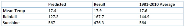
Mean temperature for the three months was the lowest since 2012, the same year that saw more rain than this summer’s 167.7mm. Both 2012 and 2011 were a fair bit wetter than this summer and this season’s rainfall wasn’t a patch on some of the washout summers of my youth – both 1985 and 1987 were at least 150% wetter than summer 2015.
More notable was the lack of sunshine – it was the dullest summer since 2002.
Looking beyond Wanstead the perceived poor summer elsewhere was largely caused by cooler than normal sea temperatures west of Ireland, together with warmer water around the Azores. Simon Keeling explains this well here.
Three months ago I predicted that summer would be broadly average temperature-wise with average to slightly below average rainfall and average sunshine. So how did the forecast do?
In terms of temperature my predicted figure of 17.4C was 0.5C lower than the result. My rainfall prediction was only 76% of what actually fell and I over-estimated sunshine by 16%.
Despite some of the dire reviews of summer elsewhere in the UK there were some fine spells
This August was the third dullest since 1881. I’ve seen mentioned recently that August used to be regarded as an autumn month. For the past couple of years the final ‘summer’ month has been very disappointing for anyone looking for fine weather – much more akin to September or even October.
A storm in south London gave this eerie light seen at Southwark Bridge on the 5th
The first third of the month began pleasantly enough with a couple of days exceeding 27C. And on the 22nd the temperature reached 31.4C, only the third occasion that the mercury has risen above the 30C mark this summer. But summery highlights were few and far between.
Just under 120 hours of sunshine were recorded – that’s 62 per cent of the monthly average, the dullest August since 1968.
There were six occasions when the maximum exceeded 25C. Mean temperature for the month was 18.2C, which is on the nose of the 1981-2010 mean. Rainfall of 79.8mm was 159% of average. The wettest day occurred on the 24th with 18.4mm of rain.
What has September got in store weatherwise? The models today (September 1st) suggest a very slow progression of high pressure ridging into the UK from the west this weekend. Until then a cool northerly flow will persist with a mix of sunshine and possibly heavy showers. Most models suggest that by the end of the week a trough will run south, bringing a spell of cloud and rain before high pressure from the west eventually cuts off the cool northerly, replacing it with little or no wind, warmer sunny spells by day and misty nights – typical late summer / early autumn weather. Models then split over what will happen with the high next week. It could stay settled or, according to the ECMWF and GFS, the start of a breakdown could happen at the end of next week.
The synoptic chart shows the frontal set up that brought the greatest daily rainfall on the 24th
My long range outlook method suggests that September will be average temperature-wise, a mean of about 15.4C, at 52% probability. The next highest probabilities are for something rather warm and warm, both at 14% probability, though something rather cool also comes out 14% probability.
The highest probability for rainfall is 45% for something average. The next highest probability is for a dry September, at 23%. Rather wet works out at 14%.
My data for sunshine only stretches back to 1878. There is a 60% chance of average sunshine in September.
My August outlook was OK – I went for an average to rather cool August. I also said there was a 73% chance of a duller than average August – so not bad overall.
Here follows the full weather diary for August…Full stats for the month here:http://1drv.ms/1rSfT7Y
1st Bright but hazy start. Cloud gradually thinned to give a sunny afternoon with just a few clouds. Warmer.
2nd Sunny start with decreasing cloud.
3rd Sunny start quickly turned cloudy and blustery with brief burst of rain at 4pm. Then dry with variable cloud overnight and breezy.
4th Bright start but lots of cloud around and breezy. This lasting through the day.
5th Cloudy start, a few bright intervals and a strange light as thunder clouds passed to the south. Some light rain.
6th Cloudy start but cloud thinned to become sunny just before 2pm. Then variable cloud through the day with another eerie sunset.
Many places around the coast recorded far more sunshine than Wanstead, typical of the type of weather experienced in August
7th Sunny start though was very cloudy at times.
8th Bright start and cloud quickly melted away to leave a stunning, sunny day in Sussex and Camber. Some cloud was seen a few miles inland but even this eventually melted away. Night turned chilly with heavy dew by dawn.
9th Sunny until 3pm then a bank of cloud brought cloudier spells. Warm overnight.
10th Bright start with sunny intervals. A burst of rain at 2pm damped the ground then it was mostly cloudy for the rest of the day.
11th Cloudy, calm start, spits and spots of rain before more organised rain in evening.
12th Cloudy start then brief sunny spells late morning before clouding up again. Warm front stalled over South Coast dumping 32mm on Herstmonceux.
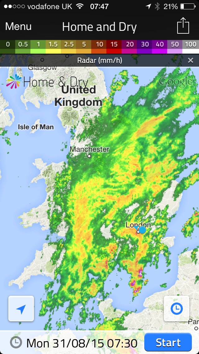
13th Cloudy with rain spreading in late morning, this lasting until 3pm with odd burst of drizzle for rest of night. Some 78mm in Polegate and flooding reported in Brighton.
14th Cloudy and very humid with some brightness late morning. Showers returned at 3.30pm then more general rain arrived at 8pm.
This radar shows the area of rain that brought over 10mm to Wanstead on 31st
15th Sunny start, clouded over at 2.30pm but then became sunny again at 5.30pm. Clear spells overnight.
16th Sunny start then cloudier in the afternoon. Very still air though made it feel pleasant.
17th Sunny start then cloudier around lunchtime. Sunny spells late afternoon though sun didn’t feel that strong.
18th Sunny start though quickly clouding over and dull. Some spots of rain on way to airport but dry in Wanstead.
19th Sunny start then going downhill with rain in the evening and overnight.
20th Bright start, clouding over.
21st Bright start before breaking to sunny spells and warm.
22nd Long sunny periods and 3rd occasion of 30C.
23rd Bright start but cloud built to give rain between 12.45 and 2.45pm.
24th Dull, rainy with rain between 9am and 11am.
25th Rain between 1pm and 3pm. Showers overnight then more general rain at obs time.
26th Dull and rain morning with squall blowing through at 1.30pm. Brightening up by 5pm then some bright spells late afternoon.
27th Bright start but with heavy cloud present. A brief shower in the afternoon before a clear evening made it chilly overnight.
28th Sunny start with light breeze, tending to cloud over middle part of the day. Skies cleared again to give sunny, pleasant evening.
29th Sunny start, cloud filled in by 3pm then rain arrived at 4pm, with moderate bursts.
30th Cloudy and humid start. Cloud stuck around all day – airless and therefore felt pleasant.
31st Cloudy start after overnight rain. The rain soon returned after 10.20am and fell, often heavily through until 12.30pm.
This month 180 years ago a huge fire consumed a large area of Wanstead Flats. Approximately one tenth of the total 335 acres of grassland was set ablaze – the cause believed to be a discarded tobacco pipe.
Looking east over Wanstead Flats from Centre Road. Long Wellesley sold off a lot of the peat on the Flats to local nurseries
At first the fire was ignored – locals thought the blaze would burn itself out or that rain would damp it down. However, it continued to grow. The Bucks Herald, on August 15th 1835, reported that in a period of three weeks the Flats had become “one mass of fire” and that in many places the blaze had descended to a depth of two feet from the surface of the peaty surroundings.
Locals, in an age where the Fire Brigade was still 30 years away from being formed, sought to put out the flames themselves. A number of horse-drawn watering carts belonging to the Essex Turnpike Trust were commandeered to carry water from a pond to extinguish the flames. For the best part of nine days residents tried in vain to defeat the fire.
Mr Speering, the deputy of the Lord of the Manor, the hapless Mr Long Wellesley, was summoned to convey the desperate circumstances to the government of the day – to try and appeal for help to defeat the blaze. Some 70 men, miners and “sappers” from Woolwich, duly arrived to dig a trench 5ft wide and six to eight inches deep around the perimeter of the blaze, but it was not before much damage was done to the land that locals depended to feed their cattle and horses.
Looking at the statistics of that summer the temperature and rainfall looks fairly average – ruling out a dry spell being the catalyst of the inferno. It was suggested at the time that the fire was exacerbated by neglect of the land – the blame therefore lying ultimately at the door of Long Wellesley.
The slow reaction time by the government of the day prompted the following poem to be published in the Leeds Times:
WANSTEAD FLATS ON FIRE
Go, ring the alarm bell, call the Crier.
And warn the neighbours the Flats are on fire.
Not Wanstead Flats; no, duller far,
And dryer, the Flats I speak of, are,
Made, like old timber that hath the rot,
Old rages, old shavings, and what not,
To crackle and blaze with vast elation
I a brief but furious conflagaration;
But enough – what need of further words? –
The Flats are on fire in the House of Lords!!
There’s Winchelsea “flaring up”, like a rocket,
With lush-light Clumber, low in his socket;
There’s Strangford blazing like red-hot steel, And Lyndhurst ignited from head to heel;
Cumberland makes that sort of show,
He’ll make one day in the – – -,
Whiz! goes Law, tied fast to the Duke,
Like a squib to a pedagogue’s peruque;
Wicklow and Buckingham, blessed pair!
Flash, like the Lesser and Greater Bear; –
In short, their Lordship’s, like Dido’s pyre,
Are all just now one mass of fire!
‘Tis a sad – a terrible case no doubt;
What shall we do? Shall we put them out?
No, let them blaze away, while we
Look on with undissembled glee,
And laugh to think, like rational folk,
How soon their fire will end in smoke!
Cold front clearance over Wanstead Flats on February 28th. The day saw three potent cold fronts with steep temperature falls. <5mm hail in the last and thunder heard in Woodford Green
Though officially the House of Commons held the reins of legislature the House of Lords still held great influence, as Lord Wellington noted that year: “The House of Lords still constitutionally possesses great power over the legislation of the country”.
The current custodians of our local parklands, City of London Corporation, would do well to take note from this story. While they are taking action in improving the care of the land it is obvious from the comments I hear while walking around the Flats and Wanstead Park that much more needs to be done.
The title of this monthly review is probably very misleading as July was a month that blew hot and cold.
The Casella ‘check’ thermometer registered 35.8C on July 1st – 0.3C lower than the AWS reading, within the contraints
The start of the month began with the July all-time record being set: 36.1C. The month ended with a couple of very chilly nights: 6.9C in the early hours of 31st with a grass minimum of 4.5C. I haven’t yet been able to go through my records but, according to the Met Office, temperatures in southern England on the same night that fell to 1C represent an all-time low July record.
There were ten occasions when the maximum exceeded 25C. Mean temperature for the month was 18.6C, 0.1C above the 1981-2010 mean and the coolest July since 2012. Rainfall of 70.4mm was 162% of average though it is worth noting that three quarters of this was recorded on two days.
There were 174 hours of sunshine recorded in this area which is 91% of what we can expect to see during an average July. The wettest day occurred on the 24th with 32.4mm of rain. There were two days of thunder recorded.
So what has August got in store weatherwise? The models this morning (August 1st) suggest very little change in the overall pattern of things. The jet stream is still well south across the Atlantic and is likely to remain so for the forseeable future. However, because we are on the eastern side of the troughed flow across the eastern Atlantic this allows the potential for some very warm or even hot conditions to be drawn up across the UK in the coming five days and possibly beyond. However, the longer projections turns the flow more west to east across the south of the UK again returning cooler air to the SE as well in week two.
This means a continuation of changeable conditions as low pressure remains anchored in the north-west or north of the UK. Thunder could be likely.
In contrast to the models my long range method suggests that we are in for a rather cool August, about 1C below average, at 41% probability. The next highest probability is for something average at 27% probability. So an average to rather cool August works out at 68% probability.
Rainfall is uncertain. There is the same probability for dry (50% average) and very wet (175% average): 23% probability. However, the next highest probability is for average at 18%.
This grainy image shows distant lightning illuminating a cloud. The storm was centred over St Albans on July 16th
My data for sunshine only stretches back to 1878. There is a 73% chance of a duller than average August.
My July outlook was very poor, I predicted a rather warm to warm month – but it was nothing like last year’s or the 2013 classic. My rainfall and sunshine predictions were also hopelessly out. However, it was the first month since January that my temperature forecast has been wide of the mark. It’s just weather – in that it frequently doesn’t do what you think it’s going to do.
Here follows the full weather diary for July…Full stats for the month here:http://1drv.ms/1rSfT7Y
1st: Sunny until after midday when cloud bubbled up and took edge of temperature. Hottest July day ever was set at 5pm. Breeze made it feel bearable.
2nd: Sunny start though cloud quickly built with rain at midday. Just 0.3mm fell which evaporated on impact with the hot ground.
3rd: Sunny, clear day though humidity began to build from mid afternoon with the appearance of cloud. Still sunny spells till late into the evening. Big thunderstorm from around midnight for an hour.
4th: Sunny and muggy start. Long sunny spells, hardly a cloud in the sky until later. Sunny dawn but rain arrived at 9am.
5th: Light rain to start. This cleared late morning to sunny spells. Feeling muggy.
6th: Sunny start though lots of fair weather cumulus bubbled up.
7th: Cloudy start with light patchy rain around 11.30am, clearing to sunny spells. Some rain after 9am.
8th Cloudy and blustery with rain in the air. A few showers around.
9th: Sunny with just a few clouds, low humidity. Sky completely cleared after 3pm for a gorgeous evening.
10th: Sunny start. Some cloud bubbling up as jetstream neared – lots of cirrus and then cirrocumulus forming. Turned sunnier late afternoon. Also dawned clear and sunny.
11th: Long sunny spells with just a few cirrus and cumulus at times. Feeling warm and humid. Some light rain around midnight but not amounting to much.
12th: Cloudy and comparatively cool compared with recently. Light rain at 5pm with drizzle in wind through evening. More rain at 7.30am that fell intermittently up to obs time.
13th: Light rain to start with bursts through morning to 10.45am. Further bursts of light rain into early afternoon then overcast and muggy all night. More drizzle early am.
14th: Drizzly start – this continued into late morning. Then overcast and muggy. More drizzly burst overnight into the early hours – drizzle was persistent from 8.30am to 9am.
15th: Sunny intervals after light drizzle.
16th: Bright and sunny spells tending to turn more cloudy after midday. Big electrical storm around midnight with 67 flashes per minute seen to the north-west.
17th: Light drizzle to start turned to bright spells and a pleasant summer’s day.
18th: Sunny start with cloud bubbling up late afternoon. Light rain shower at 8.30 at end of Music in Wanstead Park and again in early hours at 6am.
19th: Sunny morning tended to cloud in at midday before cold front cleared to leave sunny evening. Mackerel sky at dusk with light rain at 8.15am.
20th: Showery rain to start.
21st: Sunny start but clouds bubbled up through the day for long sunny spells. Warm with a breeze.
22nd: Sunny start, cloud bubbling up during the day with spots of rain at 5pm – heavy shower in Wanstead.
23rd: Cloudy with occasional bright spells, feeling humid.
24th: Drizzly start. rain started falling at 11am. Outbreaks of prolonged rain through the day, heaviest between 5pm and 6pm. More rain after 8pm but then a drier interlude before more rain at midnight as occluded front came back. Last tip of the gauge just before 4am.
25th: Sunny and breezy though much cooler. A pleasant evening at John’s party though. Cloudy spells overnight before rain moved in at 9am.
26th: Rain to start with heavy outbreaks up to 1pm. Further outbreaks of rain through the day and into the evening.
27th: Drizzly bursts of rain to 11am. Then dry and bright.
28th: Bright and breezy to start. A light shower in evening then cool and clear – sunny start.
29th: Bright start but cloud filling in. Burst of rain at 8.30pm then variable cloud overnight.
30th: Bright but a burst of rain just after 10am. Then mostly cloudy with a few bright breaks.
31st: Sunny start but cloud filled in.
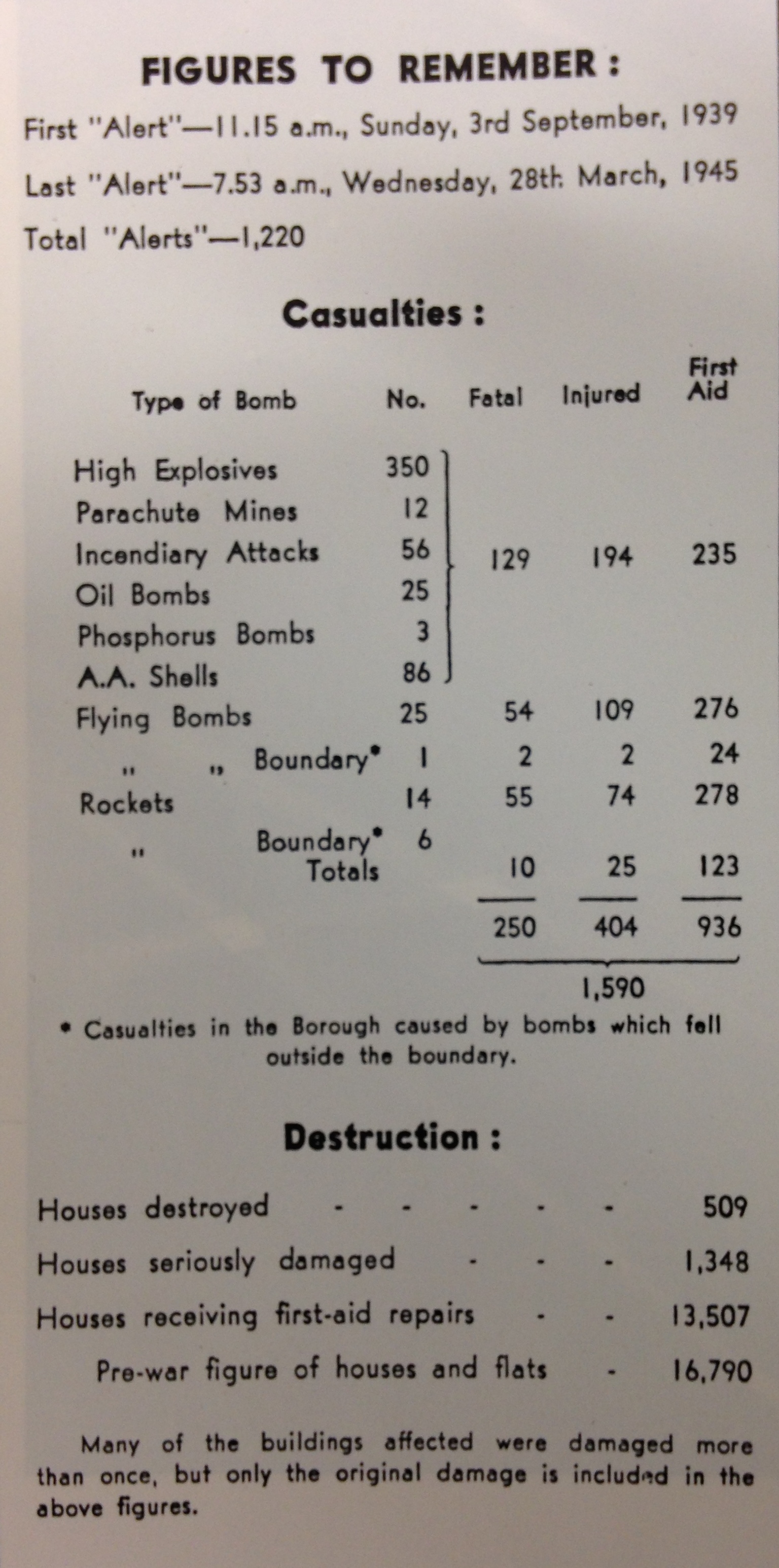
This month marks the 75th anniversary of the start of the Blitz in Wanstead and Woodford. Over a period of eight months around 450 bombs were dropped on the two boroughs, killing 129 people and injuring 194.
The Churchill statue at Woodford Green
The summer of 1940 had been varied; a warm and dry June was followed by a cool and wet July. The weather turned much warmer and drier in August, just 2mm of rain fell during the whole month. Only one August has been drier since and parts of London went 46 days without any measurable rain.
As people got on with their summer and the Phoney War (Britain had been in conflict with Germany for nearly a year) events in Europe must have seemed a world away. This all changed just after 11pm on Wednesday, August 28th when two high explosive bombs and one incendiary were dropped at two addresses in Woodford Green. Damage was light and only one minor injury was reported but the event brought home to citizens that the war was starting to happen on their doorsteps.
The days that followed were fraught with uncertainty; sirens sounded at any time of the day or night – the rapping of machine guns could be heard faintly in the skies as British fighters and enemy spotters fought invisible battles; the anti-aircraft guns pounding away on outlying sites including Wanstead Flats.
On the afternoon of Saturday, August 31st, a British fighter plane crashed in Hereford Road, taking out the front of a house and landing in the road – the pilot having earlier bailed out.
The opening week of September saw the hottest spell of the season. But summer, and the relative peace that Britain had enjoyed since the announcement of hostilities a year earlier, came to an abrupt end on September 7th.
It had been a beautiful day on the 7th with wall-to-wall sunshine and warm temperatures – the eighth day running the thermometer had reached the mid to late 70s fahrenheit. Many people were outside taking advantage of the weather when at 5pm the drone of the first Luftwaffe bombers could be heard passing to the south of the borough. By 6pm the skies were empty but all Thameside blazed.
The bombers struck again soon after 8pm, guided to their earlier smoking targets of the docks and the East End. As the sun began to set a red glow in the sky to the west and south-west gave the impression that all London was burning.
Wanstead and Woodford, so far unscathed, sent rescue parties to East Ham to help. Within a few hours, however, the area itself became the target of bombing when, at 1.25am, the first of three high explosive bombs fell in the Grove Park area behind the High Street. Two houses (Nos. 7 and 9) in Grove Park and the central block of the Shrubbery flats collapsed. A row of shops in the High Street, what is now Boots, was badly damaged by the third bomb which was dropped along with about 500 incendiaries.
A fire gutted the roof of 30 High Street, a house overlooking Christchurch Green, which is now a large block of flats on the corner of Wanstead Place, opposite the pie and mash shop.
The explosions left eight dead in the immediate vicinity while another blast in Highfield Road, Woodford Green, claimed the lives of three others. Some 50 people were injured across the two boroughs during the raid which was over by 2.30am. Rescue teams worked through the night to combat fires and tend to the injured. Wanstead and Woodford had suffered far less damage than other parts of London and a decision had already been taken to accept 2,000 evacuees from the East End. By Sunday lunchtime the first of these began to arrive in buses and lorries.
It was a dull day, ten degrees cooler than Saturday and probably reflected the public mood at the time. The bombings went on nightly through September – in the next two months there was little falling off. The manner of peoples’ lives is summed up in this entry from the diary of a local man:
“Night of September 11-12: Terrific AA barrage ended about 5am. To bed at 5.40. At 6.20 phone call saying office hit and we were to work at – . Left home at 7am. Settled down in strange building with difficulty, and grew so overwhelmingly sleepy that (having been awake for 5 nights) fell asleep standing up.”
But, two days later:
“Saturday 14th – left office 2 o’clock and spent two hours gardening. Beautiful autumn afternoon.”
As the boroughs learnt to cope with high explosive bombs, each weighing between 250-2,000lbs, the horror of the first parachute mine emerged within a couple of weeks. On September 23, a paramine fell in the Stanley Road area of South Woodford, killing 17 people – the highest number of deaths recorded in any single incident in the borough.
The borough was the first district to experience an explosive incendiary. A fire watcher of over 70 lost the sight of an eye from this type of bomb but continued on duty until the end of the war.
A warden called “Will” wrote this letter to his parents on September 29th 1940. It is intriguing for me because in the letter he mentions a house that I lived in in Cavendish Drive, Leytonstone. He says that an incendiary bomb lodged in the loft before burning through to the floor. While decorating one year I uncovered scorch marks in the landing well as well as charred damaged on the bannister and scorch marks on the floorboards – evidence of bomb damage.
As Wanstead, Woodford and the rest of suburban London got over the initial shock of the start of the Blitz people acted to keep life going as normally as possible.Many people who weren’t appointed as wardens learnt, through local authority training, to deal with incendiary bombs – airborne missiles dropped by the Luftwaffe that could easily pierce slate roofs and set fires below. Stirrup pumps could be bought and, through a family effort, fires could be extinguished or controlled until the arrival of the fire brigade.
The intensity of the night raids that brought so much destruction in September continued through October. The neighbouring borough of Woodford bore the brunt of the bombing but Wanstead, being so close to anti-aircraft guns sited on Wanstead Flats, continued to be hit. On the 11th six high explosive bombs fell on Wanstead Park, one damaging the Temple. Two days later high explosive bombs fell on land close to the City of London Cemetery on Aldersbrook Road, leaving six craters.
On the 14th three people were killed when a high explosive bomb landed in Woodlands Avenue on the Aldersbrook estate while incediaries caused many small fires in properties on Elmcroft Avenue.By the end of October the attacks started to be scaled back.
Synoptic chart for November 3rd 1940. Image courtesy of the Met Office
Bad weather at the start of November coincided with a 6-day pause in bombing incidents. It was a very cyclonic month that probably hampered German air operations. Indeed, on November 3rd, 40.8mm of rain was recorded at Greenwich – a daily record for November that remains to this day.
Another 6-day pause in the bombing happened after November 16th. When the Luftwaffe returned on Saturday, November 23rd, it was Wanstead that bore the brunt. At 4.12pm, as light was fading on a dull, dreary afternoon, high explosive bombs caused fires at and partly demolished nos 78 and 89 New Wanstead. A minute later another bomb ruptured water and gas mains in Spratt Hall Road. At 4.30pm a further high explosive bomb fell in the High Street, killing 4 people. The raid ended at 5.16pm as a bomb fell in Fitzgerald Road though this time there were no injuries.
By now the weather was beginning to quieten down though weeks of deep depressions with associated gales and heavy rain had taken their toll – many residents reported problems of Anderson bomb shelters being constantly flooded – but it was probably the design as much as the weather that was to blame. Some 171.6mm of rain was collected by month end in Greenwich – a record for this region that also remains to this day.
As pressure built in the last few days of November the first frosts of winter arrived but the bombs returned. High explosive devices fell in Woodford New Road and Bunces Lane on the 30th, fracturing a water main.
On December 3rd bombs fell in Nelson Road, Woodford Road and Eagle Lane, damaging road surfaces. Later the same night houses in Wellington Road and Elmcroft Avenue were badly damaged by bombs.
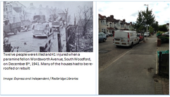
The final raid of the year, on the evening of December 8th, saw yet more tragedy befall the boroughs. Just after 7pm a high explosive bomb fell in St Albans Road, killing three people. And at 10.25pm a paramine was dropped on Wordsworth Avenue, South Woodford, killing 14 people and injuring 41.
The raids didn’t start up again until January 5th. Mostly dry, cloudy and cold weather allowed residents who hadn’t moved out to make what they could of Christmas.
The turn of the year saw the weather turn much colder as an anticyclone became established over Scandinavia. The opening week was dominated by bitterly cold easterly winds with temperatures barely above freezing, severe frosts at night and some snow – a near repeat of the severe January a year earlier.
On January 5th bombs were dropped on St Albans Crescent and Canfield Road. Further high explosive bombs fell in the area on the 7th and 11th as the cold continued to bite. The minimum on the night of the 15th/16th fell to minus 7.5°C, but during the third week a thaw set in as heavy snow turned to rain, it became misty, and temperatures slowly rose. On the 20th, nearly 17mm of rain (including melted snow) fell, and on the 22nd the temperature rose above 8°C.
A dull and rather wet February followed with temperatures close to normal. The early part of the month was cold with frost and some snow. After a minimum temperature below minus 6°C. on the night of the 4th/5th, outbreaks of snow occurred during the day and the maximum temperature stayed below freezing. Though it was cold in Wanstead much heavier snowfalls occurred over north-east England. A thaw set in at the end of the first week, and on the 8th the maximum was above 11°C.
Just one raid happened in February but further horror lay in wait in March – a month which continued the theme of the wet, miserable and dull winter.The early part of the month was unsettled with heavy rain at times. On the 6th, over 13mm fell. During the second week it became dry with sunny periods. There were some frosty nights and lingering fog. On the 12th, the maximum temperature was only 5°C. Temperatures slowly rose during the third week.
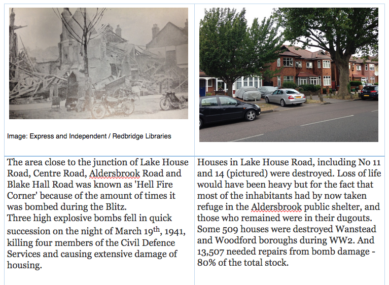
On the 19th four members of the Civil Defence Services gave their lives as they went about their duties at Post 41 “F” District headquarters (Aldersbrook Tennis Club), an area of South Wanstead, which, from the battering it received from the early days of bombing (and which later continued through the phases of the flying bomb and the V2 rocket) became known as “The Battle Field” or “Hell Fire Corner”.
The following impression of that night is written by one who was at the scene:
“The wail of the siren opposite the Post announced at 8.15pm the arrival of the raiders. The Post personnel saw a startling sight. The Flats were a sea of flame. Thousands of incendiaries were burning on the open space. The guns roared. It was obvious that the enemy was making a concerted and determined attack. Bomb flashes stabbed the blackout. Planes droned overhead. The batteries on the Flats joined those further away in putting up a terrific barrage.
At 8.50pm, three high explosive bombs fell in Lake House Road, damaging a number of houses and partly demolishing Nos 14 and 31. A few casualties resulted, one being a man who was trapped in the doorway of No. 14. Wardens heaved on the obstruction to release him. Gas escaping in the same house caused a fire. This was quickly dealt with and the flames smothered. A nearby barrage balloon had burst into flames, illuminating the scene with glaring brilliance and revealing the widespread damage.
At 9.20pm this first incident appeared closed, and services were awaiting the result of a final search and check-up before being dismissed. Then a parachute mine landed. It exploded a few yards from Aldersbrook corner on the Leytonstone side. A house in Lake House Road, already badly damaged, tottered to destruction. Number 11 caught fire and was destroyed. Loss of life would have been heavy but for the fact that most of the inhabitants had by now taken refuge in the Aldersbrook public shelter, and those who remained were in their dugouts.
The attack died down. Wardens returned to their posts – but the number for 41 was sadly lacking. The two boys’ bicycles stood in their usual place. ‘Busy somewhere’ said the chief. But the absent ones did not return, and a search was made. They were found – in the mortuary, three of them. It was known that two others had been taken to hospital. Warden Barnett was one of these. He died next morning of his injuries.
Just before the mine exploded, the messengers had been giving assistance in one of the less badly-damaged houses. Broome, although officially not on duty, had rushed out to lend a hand. Warden Hutton was endeavouring to turn off the gas at No 14 when the mine fell.
So the four from Post 41 died doing their duty on the Home Front. The two boys, pals in the service, sleep in one grave in Old Wanstead churchyard. The two men lie close by, in Ilford Cemetery.
A few days later their comrades stood silently at attention as the funeral cortege halted outside the Post. A Union Jack covered each of the four coffins.
The four members of the Civil Defence Services who gave their lives were: Thomas Hutton, 44, a warden, of Blake Hall Crescent, Wanstead; William Barnett, 36, a warden, of Belgrave Road, Wanstead; Roy Broome, 17, a messenger, of Lake House Road, Wanstead; and Herbert Stower, 18, a messenger, of Clavering Road, Wanstead.
Winston Churchill’s letter to his constituents
As spring wore on the weather remained mostly miserable though raid incidents lessened and petered out in May. Wanstead and Woodford had its last bombs of the period on May 10th. There were no more that year.
In total 129 people lost their lives and 194 were injured during the campaign. This figure would nearly double when the next phase of the bombing, using V1 flying bombs and V2 rockets, would begin three years later in June 1944.
It is hard to imagine how people coped with the constant barrage of bombs during the Blitz. What seems to get lost in articles and historical texts I’ve read is just how grim the weather was at the time – remember this was a time before central heating. Not only were bedrooms freezing cold people must have laid there wondering if they were going to see morning.
It seems to be a human condition that when we are faced with adversity we just find a way of ‘getting on with it’ as best we can.
This graph shows how much colder the weather was at the time of the Blitz compared with the period September 2014 – May 2015Wanstead and the surrounding area is shown to be peppered with bombs on the website http://bombsight.org/ but many of the accounts listed in Tiquet’s book are not listed
* Much of the inspiration for this blog comes thanks to the book It Happened Here by Stanley Tiquet. The book is available for loan and can be purchased at Redbridge libraries.


You must be logged in to post a comment.