Category Archives: month ahead forecast

May 2016: rather mild with average rain

A stunning first week of weather in May 2016 probably led a few people into believing that we were in for a glorious start to the summer. But the second Sunday in the month when temperatures reached 27.1C under 13 hours of sunshine was about as good as it got.

view
May 10th 2016 looking toward Crown Hill from Dunton in Essex

The warm first week helped maintain the mean temperature to finish above average: 14.3 which is 1.2C warmer than average, the warmest May for five years.

Though on paper rainfall looked a little under average 44 per cent of the monthly total fell on the last day. Some 43.4mm fell during the course of the month, that’s 85% of what we can expect during a normal May.

Sunshine was about average. Some 184.5 hours were were recorded, 101% of what we can expect to see during an average May.

The wettest day occurred during the meteorological 24hrs of the 30th (09-09 31st) with 14.7mm, rain associated with a depression in the North Sea. Incessant cloud held temperatures down to 12.6C, the coldest May 31st for 36 years!

convey
A conveyor belt of rain brought the coldest May 31st for 36 years

Air frosts: 0, Ground frosts: 5

So what has June got in store weatherwise? The models on the 1st suggest only slow changes in the next 3-4 days. These changes revolve around the release of low pressure from Europe towards high pressure later next week. This process begins as high pressure also begins to build down from the north at the weekend with several days of fine and increasingly warm conditions as the cool NE’ly flow is lost to warmer winds from the SE or south. Then next week with higher pressure over Europe and low pressure drifting slowly north or NE towards the west of the UK it could become very warm and humid in places and as that low to the west pushes troughs towards us from the SW it could feed some thundery rain and storms up from the SW at some stage by midweek. The pattern thereafter appears quite mixed. GFS suggests a more traditional pattern of low pressure to the NW and higher pressure to the SE with SW bringing rain at times to the north and west while the south and east see the best of prolonged dry and warm periods between intermittent rain.

high
High pressure to the north of Scotland brought often miserable, overcast weather to our region

Beyond the grasp of the models my long range outlook method suggests an average to rather mild month. The highest probability is 29% for something a little above average and rather mild. A little below average and mild both come in at 14% probability. Something cool or very cool comes in at 7%. If you combine the first two probabilities together something just over average would come in at 58%

A dryer than average month looks most likely at 57% probability. Sunshine probably about average.

So to sum up: mean 16.9C (0.8C above average), rainfall 38mm, sunshine 178 hours.

My May outlook for temperature was poor. I predicted a mean of 12.8C (outcome: 14.3C). Rainfall was also poor: 58mm (outcome: 43mm). Sunshine was good: 184.5 hours (outcome: 179 hours).


Here follows the full weather diary for May…Full stats for the month here:http://1drv.ms/1rSfT7Y

1st: Sunny start though with cirro cumulus around. Cloud tended to thicken up through the day to leave overcast late afternoon. A warm night followed.
2nd: Cloudy with spits and spots of rain to start. Some bright spells late morning but then overcast and some rain at 6.40pm – a decaying front gave little rain. Clearing overnight and cold.
3rd: Sunny with fair weather cumulus developing.
4th: Sunny, gin clear start with just a few fair weather cumulus developing. Clear and cold overnight.
5th: Sunny and warm, some hazy cloud in the afternoon.
6th: Sunny start though turned much more hazy than yesterday. Feeling humid.
7th: Hazy sunshine to start with high level strato-cumulus bringing cloudier periods.
8th Sunny start with just a few clouds. Air much clearer than yesterday and hot by mid afternoon on Canary Wharf.
9th: Cloudy start but became sunny late morning. Rain arrived 5pm, turning moderate 7.30pm and outbreaks through the night.
10th: Light rain to start, this turning moderate at times throughout the day, though petering out at 2.30pm.
11th: Dull, damp start that went into 11am. Heavy showers developing that lasted until late afternoon.
12th: Sunny start though with a fair bit of cirro cumulus floating around. Feeling very warm.
13th: Sunny start with spotted cirro cumulus. A pleasant day.
14th: Bright start with sunny spells into the morning. Cold wind took edge off sunshine.
15th: Sunny and cool with a cool breeze.
16th: Sunny start but quickly clouded over. Bright spells into the afternoon.
17th: Sunny start but cloud soon filled in. Sunny periods around lunchtime before more cloud arrived.
18th: Cloudy start after recent light rain. Bursts of rain at 11.20am, turning heavy at 12.30pm. Some more rain at midnight.
19th: Cloudy with brief sunny intervals before noon. Then cloudy.
20th: A Cloudy and breezy day. Feeling humid.
21st: Cloudy and breezy through the day though mild. Brief shower at 6pm while driving back from Broadstairs.
22nd: Sunny start though cloud increased during the day to fill in by 2.30pm. Showers, one moderate, from 6pm.
23rd: Sunny start but lots of cloud bubbled up. A lot of threatening cloud to west and east with funnel cloud spotted over Leighton Buzzard. https://twitter.com/Chxrlie_Mxrch/status/734818236211068930 Cleared overnight to leave cold night.
24th: Sunny start quickly clouded over by 11am, then just sunny intervals
25th: Cloudy and cool all day thanks to HP bringing drift off North Sea.
26th: Sunny start with sunny spells though the day
27th: Cloudy start though with sunny spells developing at lunchtime and a clearance around 1pm – 2pm. More convective cloud bubbled up however, to leave a humid evening. Rain developing at 7am.
28th: Cloudy, damp start though with a little brightness at 11am. Some sunny intervals in the afternoon though much cloud.
29th: Cloudy and cool start. Hazy sunny spells in early afternoon, though still much cloud around.
30th: Cloudy with just two sunny intervals that momentarily lifted the temperature. Rain started at 7.30am and was heavy at times up to obs time. Elderly man killed on crossing, possibly due to the bad weather
31st: Rain to start. Outbreaks lasted up until 1315z then stayed cloudy, damp and chilly into the evening and night.


April 2016: rather cold and thundery

April 2016 has seen more occurrences of thunder than we can expect during a typical July.

radar hail
About an inch of hail collected on borders in gardens in Plaistow during a thunderstorm on 29th. This stuck around for over an hour thanks to the low humidity

A persistent flow of unstable Polar maritime air, coupled together with strong sunshine, provided the perfect ingredients for some really beefy showers.

The mean temperature of 9C was 0.8C cooler than average, the coldest April for three years and in stark contrast to the previous two Aprils that were mild and very dry. Air frost, notable for its absence in the previous two Aprils, returned with four incidences where the temperature dipped below freezing

Apart from a dry slot in the third week rainfall was fairly steady: 52.5mm is 124% of average for this area. It was the wettest April for four years.

bracka20160415
A depression on 15th led to the wettest 24hrs of April

Sunshine was just below average. Over 153 hours were recorded, 96% of what we can expect to see during an average April.

The wettest day occurred on the 15th with 15.9mm, rain associated with a depression that ran along the Channel coast out into the North Sea, a system that heralded the colder pattern that defined the rest of the month.

Air frosts: 4, Ground frosts: 12

So what has May got in store weatherwise? The models on the 1st suggest that rather warmer weather will develop as we finally lose the northerly-sourced airflow and low pressure across the UK.

hail radar
The radar on 29th shows a thunderstorm right over Plaistow to the south of Wanstead

Low pressure to the NW will become influential with strong and milder WSW winds driving wind and rain bearing fronts east and SE across the UK late on Sunday and Monday. A bright and brisk NWly flow with sunshine and showers then looks likely to be replaced by a ridge of high pressure and drier weather. It will begin to feel quite warm in any sunshine across the south from midweek.

Beyond that the outlook is uncertain though it appears warmer, if changeable, conditions will prevail.

Beyond the grasp of the models my long range outlook method has conflicting signals. The highest probability is 32% for something rather cool. Average is 28% while rather mild comes in at 20% probability. Something cool comes in at 12%, while mild is 8% probability. Both cool and very mild have a probability of just 4%.

A wetter than average month looks most likely at 48% probability. Sunshine probably about average.

So to sum up: Mean: 12.8C (0.2C below average), rainfall 58mm, sunshine 179 hours.

My April outlook for temperature was good. I predicted a mean of 9.2C (outcome: 9C). Rainfall was also good: 57mm (outcome: 52.5mm). Sunshine also good: 149 hours (outcome: 153.9 hours).

Here follows the full weather diary for April. To view full stats follow this link:http://1drv.ms/1kiTuzv

1st: Sunny start though lots of haze around from late morning.
2nd: Sunny until 2pm before cloud then light rain spread in – this lasting into the evening.
3rd: Sunny start with hazy cumulus building through the day.
4th: Bright start though lots of cloud around. Some gin clear spells of sunshine.
5th: Sunny start though with variable cloud through the morning.
6th: Drizzly start, giving way to sunny spells and showers.
7th: Cloudy after recent light rain. Windy and cold. Some heavy showers mid to late afternooon with flash of lightning and thunder at 4pm and hail >5mm.
8th: Bright start though with much cloud around. Some brief sunny spells and v light showers.
9th: Cloudy, damp start after morning rain. This broke to sunny spells at 1pm ish. Cloudy again later but clearing at dusk to allow a frosty night.
10th: Sunny start but soon turned hazy with keen, cold SE wind building through the day.
11th: Cloudy start but brief brightness early afternoon. Rain at 2.15pm – this lasted until 5pm. More rain in the early hours, heaviest just before 5am.
12th: Bright start though hazy with lots of cirruo stratus. Clear and cold overnight.
13th Glorious sunny start and warm in the sunshine. Some patchy cloud at times. More cloud bubbled up late afternoon with a shower at 8pm and midnight. Clear and cold overnight.
14th: Sunny start though with much more cloud at times to 2pm. Showery rain in the evening lasted through the night.
15th: Cloudy with rain at 9.45am until 10.15 then turned a bit brighter before cloudy again at 11.45am. Rain set in at 12.30pm with thunder at 1.07pm then rain on and off into the evening. Clearing overnight and cold.
16th: Cloudy and cold start. Stayed cloudy all day with brief light rain shower. Cold and frosty overnight.
17th: Sunny, gin clear start with cloud gradually bubbling up. Sunny periods throughout the day.
18th: Sunny start with cumulus bubbling up.
19th: Mostly sunny start but then turned very cloudy. This cloud cleared just before noon.
20th: Sunny, clear start with just a few cirrocumulus drifting around during the day. Cold wind.
21st: Bright start but much cloud around. Some spells of hazy sun through the afternoon.
22nd: Cloudy, cold feeling start. Rain by 5pm, this heavier than expected. Next day dawned clear but cloud soon bubbled up.
23rd: Sunny start, cloud bubbled up with a shower at 12.25pm, clearing by 1pm. Early rain on 24th before obs time.
24th: Bright start, cloud bubbled up with light shower at midnight.
25th: Cloudy, cold start with lots of Arctic cumulus. Showers soon arrived that were mostly sharp but brief and heavier in the east. These cleared to leave a cold, breezy night.
26th: Sunny start but cloud quickly bubbled up. Some heavy showers of soft hail with odd snow flake. Thunder at 2.45pm.
27th: Sunny start though cloud quickly started building with snow and soft hail at 12.30pm. Further showers at 1712 and 2330. Clear, cold and frosty overnight.
28th: Sunny and mostly clear up until  12 noon.
29th: Sunny start though cloud quickly bubbled up. Some very heavy hail in Plaistow with an accumulation of one inch – this hung around for a while due to the low dew point and low humidity – less in Wanstead. Thunder and lightning too.
30th: Sunny, clear start though cloud began to bubble up. Felt cold in the wind as it became overcast last afternoon. Cleared overnight to give frost.

bluebells
Another superb display of bluebells burst into life in Chalet Wood, Wanstead Park, this month

March 2016: cool and wet

With the meteorological winter over the first month of spring saw the weather return to its modern type: cooler than average just when most people are looking for warmth.

squalllengthofuk
The squall of March 26th ran the length of England

The mean temperature of 6.7C was 1C cooler than average, the coldest March for three years and the first month more than 1C below average since last September.

The wet end to the month tipped the rainfall statistic well above average: 60.3mm is 148% of average for this area. It was the wettest March for eight years, notable because of a 14-day dry spell during the middle part of the month.

Sunshine was just above average. Over 116 hours were recorded, 107% of what we can expect to see during an average March.

The wettest day occurred on the 27th with 14.4mm, rain associated with blustery weather fronts from Storm Katie.

Air frosts: 7, Ground frosts: 14

So what has April got in store weatherwise? April is often a month when we can see huge swings in the weather from day to day as the natural warming of the atmosphere competes with the decaying coldness of northern latitudes.

squallonsynop
The squall of March 26th ran the length of England

This often results in big showers and vast temperature differences not only day to day but between night and day too. All of the above is going to be on offer over the coming few weeks if the model output on the 1st is correct. A warmer phase will begin the month as winds switch southerly, drawing warmth from Spain. However, with low pressure close big showers and outbreaks of rain should be expected. Then as the low switches to the NE of the UK the door opens next week for colder NW winds with further rain or showers and chillier air. A lot of output strengthens this northern sourced air through the second week and with low pressure never looking likely to be far from the UK we will be looking at lots of showers and spells of rain.

Beyond the grasp of the models my long range outlook method suggests the April mean will be average or just below at 60% probability. Rather cold comes in at 20% while cold has a probability of 20%. There appears no chance of something mild.

squall26032016
The squall of March 26th ran the length of England

A wetter than average month looks most likely at 40% probability. Sunshine probably about average.

So to sum up: Mean: 9.2C, rainfall 57mm, sunshine 149 hours.

My March outlook for temperature was good. I predicted a mean of 5.9C (outcome: 6.7C). Rainfall was way off: 31.6mm (outcome: 60.3mm). Sunshine also out: 68 hours(outcome: 116 hours).

Here follows the full weather diary for March. To view full stats follow this link:http://1drv.ms/1kiTuzv

1st: Drizzly start turned to steady rain at 10am – this lasting past lunchtime but drying up to leave a cloudy afternoon. Very sharp squall blew threw at 2am with brief intense rainfall.
2nd: Bright start but soon turned very blustery and showery. Brighter after 3pm but cold as dew point fell away.
3rd: Sunny, cold start. Cloud bubbling up late morning.
4th: Sunny, gin clear start. Cloud bubbled up through the day. Clearing in the evening to leave a very cold early hours. Light rain moving in at obs time.
5th: Cloudy start with small area of rain around 10pm. Brief brightness at noon before more light rain moved in. Clearance again at 3.30pm. Small hail <5mm at 5pm. Clear spells overnight.

squallfall6c
The squall of March 26th ran the length of England

6th: Sunny, cold start. Coud bubbling up late morning.
7th: Sunny, cold start with light winds. Variable cloud but feeling cold, especially so overnight.
8th: Cloudy, calm and cold start.
9th: Very light drizzle am before briefly brightening up. Heavier rain pushed in between noon and 2pm. More rain at intermittent periods into the evening.
10th: Cloudy until 2pm. Cleared at dusk to leave a frosty, cold night with thick fog patches on Centre Road.
11th: Sunny start with early mist clearing. Variable cloud through the day. Clear spells up to midnight but then tending to cloud over.
12th: Cloudy start tending to brighten up though sunshine remained mostly wintry.
13th: Cloudy start quickly cleared to leave sunny morning. Pleasant until a keen N’ly wind set in.
14th: Bright start with cloud quickly breaking, cold wind.
15th: Cloudy and dull start. Mostly cloudy through the day.
16th: Bright start but cloud filling in by 10am. Mostly cloudy all day
17th: Sunny and clear until 11am – patchy cirrus thereafter.
18th: Cloudy, cool start – the cloud lasting past 12 noon.
19th: Cloudy start – very brief drizzle. Brief brightness just before 10am then cloudy.
20th: Cloudy start brief sunshine at 10am-ish before cloud spilled across. Another clearance at 11am before cloud returned for afternoon.
21st: Cloudy until brief sunny spells at 10.30am. Much milder for a time before a mostly cloudy afternoon.
22nd: Mostly sunny all day with just a few cumulus.
23rd: Cloudy all day
24th: Cloudy, chilly start. Rain spread in by 1pm and turned heavier in the evening, clearing around 3am to showers. Sunny dawn.
25th: Sunny start with just patchy cumulus
26th: Cloudy with intermittent light drizzle. Very heavy squall at 6pm brought 5C fall in temperature.
27th: Sunny start but with some very dark clouds around. Squally winds and showers thereafter at 11.30 and 2.30pm.
28th: Cloud and rain to start and very windy due to Storm Katie, becoming fine by mid afternoon though heavy showers moved in.
29th: Bright start with cumulus dotting the sky. Cloud thickened up during the day with heavy showers in the evening.
30th: Sunny start with fair weather cumulus doting sky – this lasting all day.
31st Sunny, misty start


February 2016: average contrast

Though it was devoid of snowfall February 2016 was average for temperature and sunshine and on the dry side.

broadstairs
On the 15th cold northerly winds brought sharp showers to the coast. A big swell was seen at Broadstairs allowing for some good surfing conditions

Some sharp frosts made for a couple of stunningly sunny days, “ski resort weather” the kind of days that were absent during the first half of winter after the super mild December.

Rainfall of 35.1mm was 90% of average – the driest February for three years. Mean temperature for the month was 5.4C, 0.1C above the 1981-2010 mean.

Sunshine was just above average. Over 79 hours were recorded, 108% of what we can expect to see during an average February.

The wettest day occurred on the 7th with 11.6mm.

Air frosts: 10

Ground frosts: 16

low
A rare Channel low but conditions weren’t cold enough for snow

So what has March got in store weatherwise? The late winter synoptic pattern could see the first snowfall above 1cm over the coming days and next week though amounts are likely to be small and temporary and restricted to night hours.

The pattern bringing this messy wintry mix is low pressure moving SE across the UK between now and the weekend each band bringing progressively colder air across the UK. Much of the precipitation will be showery although Friday looks more interesting as a secondary moving south brings cold N or NE winds. Models suggest next week will see high pressure from the west displacing this cold N. The timescale is very uncertain and it may be toward the second half of next week before the general theme of dry and settled conditions prevail. Frosts at night remain likely and daytime temperatures remain close to or a little below normal.

Overall the first half of March does not look like it will offer much in the way of spring weather.

My long range forecasting method suggests the most likely scenarios to be rather cold or cold, though both are only at 33% probability. Something average or below works out at 83% probability. The only mild indicator is for something rather mild at 16% probability.

squall
On the 15th cold northerly winds brought sharp showers to the coast. A big swell was seen at Broadstairs allowing for some good surfing conditions

A dryer than average month looks most likely at 66% probability. Something wetter than average works out at 34% probability.

Very dull conditions look most likely at 83% probability.

So to sum up: Mean: 5.9C, rainfall 31.6mm, sunshine 68 hours.

Taking all of the above into account perhaps the most likely scenario will be that the month will be predominantly anticyclonic with lots of gloom during the day and night frosts, varying in intensity.

So to sum up: Mean: 5.9C, rainfall 32mm, sunshine 67 hours.

My February outlook for temperature was good. I predicted a mean of 5.9C (outcome: 5.4C) with 31.6mm of rain (outcome: 35.1mm). Sunshine 68 hours (outcome: 79.5hrs)

Here follows the full weather diary for February. To view full stats follow this link:http://1drv.ms/1kiTuzv

1st: Cloudy, breezy start. Sunshine PM with nacreous clouds reported on east coast. Cold in a brisk wind.
2nd Cloud gave way to sunny spells around 11am – then feeling cold in a brisk wind.
3rd Cloudy and cold start then mostly cloudy with a cold wind.
4th Bright though mostly cloudy start. Cloudy through the day with odd spot of drizzle through the night. Area of very light rain gave about 0.1mm before 9am.
5th Cloudy with light drizzle up to 11am then briefly bright before more drizzle arrived.
6th Cloudy to start with odd burst of drizzle. Very windy and feeling chilly in wind. Rain arriving after 8pm.
7th Sunny start though cloud bubbling up after 11am and feeling cold in wind as dew point fell away. A very heavy, violent squall swept through at 2245z then blustery through the night.
8th Sunny start quickly gave way to squally showers which were mostly light. Strong winds into the afternoon with squally but light showers. Chilly overnight.
9th Cloudy and cold start, briefly clearing before noon before clouding over again.
10th Cloudy start though with some weak brightness lunchtime.
11th Mostly sunny all day and calm – warmth of the sun can now be felt. Just a few cirrocumulus. Stunning.
12th Bright start but cloud thickening. Day felt cold though as DP fell away.
13th Cloudy start with drizzle at obs time. Cold wind through to lunchtime and intermittent drizzle.
14th Bright, cold start with cloud increasing through the morning.
15th Bright, cold start with lots of wispy cirro-cumulus around. .
16th Stunningly sunny and frosty start. Just patchy cirrus through the day.
17th Cloudy through the day until 5.30pm when drizzle then rain set in.
18th Initially cloudy but then quickly brightened up. Sunny spells through the afternoon.
19th Sunny, clear and frosty start. Cloud began to build mid morning becoming overcast by noon. Light rain spread in about 4pm. Milder.
20th Bright start but cloud and wind quickly built. Light at times moderate rain fell through the afternoon – a thoroughly miserable day.
21st Dull, dry day up to 1pm. Very mild. Staying cloudy overnight with rain arriving at 5am, most falling until 7.30am.
22rd Drizzly start turned to a dull, overcast day
23th Cloudy with clearance at 11.30am. More cloud appeared to leave sunny spells. Much advection but cleared to leave frosty night.
24th Sunny, clear and frosty start. Lots of sunshine but quickly turned cold after dark with early frost. Cloud then wind lifted temperature though.
25th Bright start but quickly clouded over to become cold. Clearance in evening allowed temperature to fall quickly but cloud moved in and breeze picked up to prevent a sharp fall.
26th Cloudy, cold start. Brightening up to sunny spells by 1pm. Too much cloud overnight for a frost.
27th Bright start but became cloudy through the day with a cold easterly wind.
28th Cloudy start but some brightness around noon
29th Cloudy start but soon brightened up with long sunny spells before clouding in again early afternoon.

December 2015: Exceptionally mild

December 2015 was a ridiculously warm month, the mildest on record in my local series going back to 1797.Top 10 warmest Dec means

The mean temperature of 10.9C is 5.3C above the average for the first winter month and breaks the previous record set in 1974 by an increadible 2.2C.

Indeed the month was warmer than what was a very mild November and was air frost free.

sahara
A persistent flow of air from the Azores was responsible for the unseasonal warmth

Sunshine was below average: 34.6hrs (86% of average) was the lowest total recorded since 2010, another December that was as exceptionally cold as this month was mild.

Rainfall was more run-of-the-mill: 44mm fell during the month: that’s 83% of average.

The warmest day occurred on the 19th with 16.3C recorded, the second warmest December day in my daily record going back to 1959 – the record fell short by just 0.1C.

warmest xmas daysOther daily records were broken including for daily mean temperature: 14.3C on Boxing Day smashed the previous record set on December 4th 1985 by 0.4C. This day also saw the highest daily minimum for December recorded: 13.5C. It was also the warmest Christmas Day on record in a series going back beyond 1852.

decrain
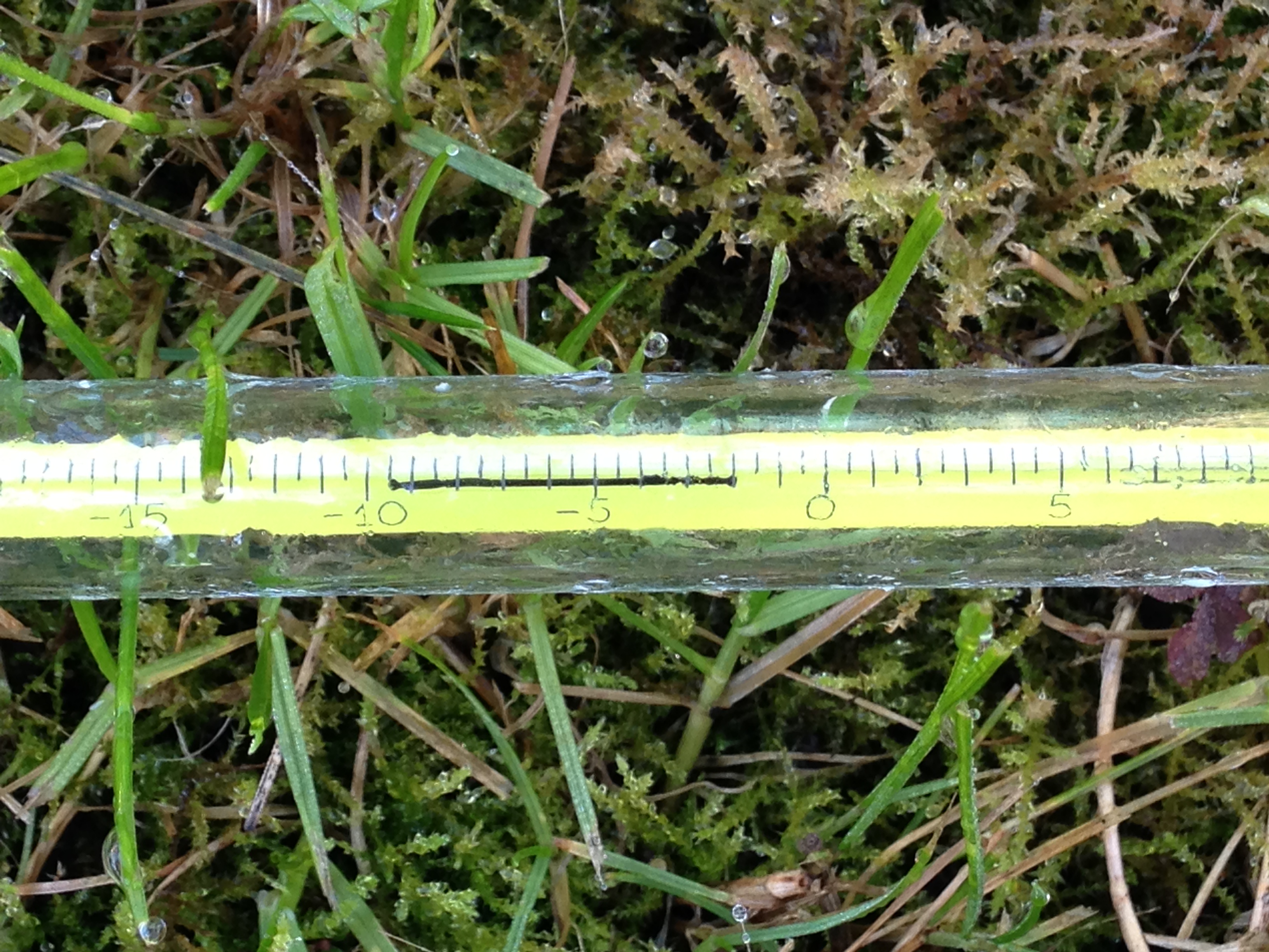
The lowest temperature occurred on the 8th when the mercury fell to 2.4C.

The wettest day was on the 3oth when 5.9mm of rain fell. There were only three completely dry days during the month. Thanks to the synoptic situation this area thankfully escaped the awful flooding which affected the north of England and Scotland.

december mean 1797-2015
There is quite a marked upward trend in the December mean since 1797

What has January got in store weatherwise? The models today (January 1st) suggest that low pressure will continue to pile into the UK from the west on quite southerly latitudes over the next week with some colder air infiltrating into the east and north of the UK from Europe with rain at times for our area. From that point on most output suggests largely unsettled weather continuing until the end of the two week period though there is a hint that high pressure may try to edge up from the SW or west later with less wind and rain but still mild.

Because of the exceptionally mild December there are virtually no figures I can work with to try to estimate January – but I’ll have a crack anyway, using figures that were at least 1C above the 1981-2010 December average.

A mean of about 5.2C with 59mm of rain, both around average. The highest probability is for average temps at 33% probability. Interestingly something ‘very cold’ comes in at the same probability. Rather mild and rather cold come in at 16% probability. I emphasise that even at such low probability my confidence is even lower.

My December outlook for temperature was way off – there was no chance shown of anything ‘very mild’.

Here follows the full weather diary for November. To view full stats follow this link:http://1drv.ms/1kiTuzv

1st: A few spots of rain after deluge overnight then cloudy.
2nd: Cloudy to start, some sun mid morning before it clouded over with two spots of rain. Mild overnight.
3rd: Cloudy start with little brightness all day. Rain moving in at 7.15pm and intermittent into the evening, clearing later with temp falling from midnight.
4th: Sunny, clear start, tending to cloud over at 11am with limited brightness.
5th Cloudy and windy all day – the wind peaking at 9pm but remaining fresh through the night.
6th: Cloudy and dull most of the day.
7th: Cloudy start with some light drizzle mid morning.
8th: Dull, drizzly start with steadier bursts. Heavy rain as front cleared through at 2pm. Evening and overnight much colder than of late.
9th: Sunny start, clouded over afternoon.
10th Cloudy start and through the day. Rain spreading in in the evening, clearing by midnight.
11th: Cloudy through the day until 2pm when a narrow band of rain passed through then dry and feeling cooler.
12th: Cloudy start with some drizzle around 10am.
13th: Cloudy and drizzly to start then just cloudy.
14th: Cloudy start with some brightness at noon. Cloudy into the afternoon with some drizzle overnight.
15th: Cloudy and dull. Rain later in the evening.
16th: Cloudy with two sunny intervals then cloudy with odd drizzle.
17th: Cloudy with odd brightness then rain at 5pm.
18th: Cloudy all day.
19th: Bright and breezy start.
20th: Dull start with heavy rain at 3.40pm. Then cloudy but clear by morning.
21st: Sunny start but quickly clouded over with rain.
22nd: Dull start with patchy drizzle up to 11.30am. More rain later with squall at 8pm.
23rd: Sunny start with cloud moving in then sunny spells.
24th: Sunny start quickly turned cloudy with heavy rain around noon, clearing to sunny spells.
25th: Cloudy start with light rain spreading in at 10.10am. Cloudy rest of afternoon with temperature climbing through the day for record warm Christmas day. Temp didn’t fall below 14C all night.
26th: Cloudy and warm all day. Temp fell to just 13.9C though the day then rose again to give the warmest December night on record, and also warmest December mean.
27th: Dull with brief burst of drizzle early then breezy and very mild. Clearer overnight and cooler than of late. Sunny start with pink clouds am.
28th: Sunny start with just a few cirrus. Mostly sunny through the day.
29th: Sunny start with brief heavy shower at 10.05am. Then sunny intervals.
30th Cloudy and breezy to start. Rain spreading in in the evening, stopping around midnight
31st: Sunny and clear to start but with cloud bubbling up from late morning. Brief rain after dark then dry and turning colder. Frost in early hours of 1st

November 2015: Very mild and dull

The final month of autumn was most notable for its warmth and lack of sunshine.

14112015 rain
Rainy days were common through November. This system brought 5.6mm 

The November mean was 10.5C, the third warmest on record back to 1797. Only 2011 and 1994 were warmer.

Just 31.7 hours of sunshine were recorded in this area: 54% of average, the dullest November for 47 years, and 9th dullest in the series going back to 1881

Rainfall was more run-of-the-mill: 64.3mm fell during the month: that’s 109% of average.

The warmest day occurred on the 6th with 17.2C recorded. The first air frosts of autumn were recorded. The lowest temperature occurred on the 21st when the mercury fell to -4.1C.

The wettest day was on the 3rd when 7.5mm of rain fell. There were only three completely dry days during the month – a real problem for anyone who works outside.

photo (8)
The beginning of the month was foggy

The sunniest days were on 21st and 22nd when four hours of sunshine were recorded.

What has December got in store weatherwise? The models today (December 1st) suggest the beginning of winter will be held at bay with most model output keeping the Atlantic in control of the weather – persistent high pressure to the SW, south and SE and a strong jet stream funneled between this high pressure zone and low pressure to the north and NW.

Winds throughout the first 15 days will be blowing from between SW and NW.

Because of the exceptionally mild November I wonder how accurate my long range method will be in estimating December – but in the interests of consistency I’ll have a crack anyway.

A mean of about 5.1C with 70mm of rain, on the wetter side of average and with average to slightly below sunshine. The highest probability is for rather cold at 50% probability. Average 25% and rather mild, suggested in my winter forecast, comes in at 25% probability.

My November outlook for temperature was way off. I predicted a mean of about 9C, rather mild, but the result was 10.5C, very mild. This chance showed at just 6% probability.

Here follows the full weather diary for November. To view full stats follow this link:http://1drv.ms/1kiTuzv

1st Foggy start, lifted to brief sunny spells early afternoon before mist thickened up again and saw Wanstead Flats’ fireworks cancelled
2nd Foggy start. This cleared earlier than yesterday but sunshine was weak
3rd Cloudy start though turned brighter at 10.30am. Spots of rain at 5.30pm then cloud and mild. Rain at first light
4th Rain to start then briefly brighter
5th Cloudy then rain from 2.30pm to 5.30pm. Mild and damp overnight
6th Short burst of rain at 9am then more at 9.45am. Further short bursts of rain but then mostly cloudy
7th Light rain to start, this grew heavier through the morning with quite gusty winds – the first of the autumn. Heavier showers earlier afternoon before the rain cleared at dusk
8th Cloudy with only brief brightness. A light shower in the evening
9th Cloudy through most of the day and very breezy. F6 at Walkie Talkie
10th Cloudy to start and very breezy. Spots of rain at 2pm
11th Cloudy through the day and breezy
12th Sunny start though cloud tended to fill in as breeze picked up from ‘Abigail’
13th Sunny start , gradually clouding over with some sharp gusty showers and a heavy one at 2pm
14th Light rain, becoming heavier though turning patchy around noon. Heavier again at 2pm. Petering out in the evening
15th Bright blustery start, the wind continuing through the day
16th Cloudy start with some initial brightness, then cloudy. Rain when we turned up at 8.45, heaviest at 10.45pm
17th Cloudy up until 1pm when it started to rain. Breeze began to pick up with gusty evening – 33.6mph was strongest gust since St Jude storm – wind moderated after 10pm but remained breezy
18th Sunny, bright start though gradually clouded over as breeze picked up. Some squally showers around, mostly south of the river with rain lashing off side of buildings
19th Cloudy start with light rain spreading in at 10am. Outbreaks of light rain until lunchtime then a heavier shower at 3pm. Then overcast and cooler
20th Cloudy start – this cleared just before 1pm to give sunny spells. NW’ly set in through the day with ever cooling air. Sleet falling at 7am
21st Cloudy with heavy burst of sleety rain at obs time. Sky quickly broke to sunny spells but a very cold wind. A cold night
22nd Sunny and sub zero to start after heavy overnight frost. Sunny spells through the day, the frost returning at 2.50am
23rd Sunny, frosty start with some alto cumulus. Cloud grew thicker with rain before midnight that was light through the early hours
24th Cloudy start but with light rain spreading in from 11.30am then stopping and staying cloudy.  More rain overnight
25th Light rain to start, stopping at 9.40am then cloudy. Temp dropped through the day with sunny spells
26th Sunny start then turned more cloudy at 11am
27th Cloudy start. Some warm sunshine late morning then turned cloudier with strong gusty squall at 7.30pm. Clear spells overnight that led to ground frost
28th Sunny start, clouding over at 10.30am before light rain spread at 2pm and then gusty winds after dark
29th Cloudy and breezy most of the day thanks to Clodagh
30th Cloudy and breezy with occassonal drizzle

October 2015: average temps and rather dry

This October was the coolest since 2012 though the mean of 11.7C is just 0.1C below average – nearly 2C colder than the same month last year.

The last week of the month saw the leaves turning in earnest. The horse chestnuts, such as this one in Wanstead Park however, turned much earlier because of the leaf miner pest

A persistent anticylone around mid-month pumped quite cool air from the north-east for a time, prompting some cold nights. Though we have yet to experience an air frost this autumn the ground temperature fell below freezing on five nights – that’s five occasions more than last year: -2C was recorded during the early hours of the 8th.

The month was rather dry: some 46.8mm of rain fell which is 70% of what we can expect in an average October. The wettest day was the 27th when 19.4mm fell. The heavy rain in the early hours of the 28th was quickly replaced by sunshine and a stunning day followed.

Just over 91 hours of sunshine were recorded – that’s 86% of what we can normally expect in an average October.

What has November got in store weatherwise? The models today (November 1st) suggest this week will see a gradual decline in conditions overall as the ridge from Europe weakens and weak Low pressure edges up from the south and SW. Thereafter it looks like winds will settle SW’ly as high pressure relocates to the south of the UK, bringing this area mild temperatures and mostly dry and bright conditions – though a little rain will be possible at times. Overall the models continue to have little appetite to serve us up anything remotely cold and stormy.

My long range outlook method suggests that November will be average to rather mild temperature-wise, a mean of about 8.9C, at 56% probability. The next highest probabilities are for rather cold or cold, at 18% probability. The chance of a very mild month comes out at just 6% probability.

The highest probability for rainfall is 69% for something average to rather dry, between 37mm and 59mm. A wet November comes in at 20% probability.

My data for sunshine only stretches back to 1878. The signal is for something average, at 60% probability.

Looking beyond November it is notable that October 2015 was very similar to October 1997 – the year another strong El Nino occurred. A very mild winter unfolded from 1997-98, though I’m sceptical about how much influence ENSO has on our part of the world.

With the sun lower in the sky at this time of year there's often a great opportunity for a decent sunset
With the sun lower in the sky at this time of year there’s often a great opportunity for a decent sunset

My October outlook for temperature was good in that I estimated that there was a 44% chance of the mean being average. My rain estimation was way out in that a signal for a rather dry October was only a 22% probability – though bearing in mind that the probability for a wet October was only 33% it is not surprising the outcome was wrong.

Here follows the full weather diary for October…Full stats for the month here:http://1drv.ms/1rSfT7Y

1st Sunny with just a few wispy clouds. Heavy overnight dew.
2nd Sunny and clear all day and evening. Mist thickened overnight with fog elsewhere in the UK.
3rd Misty start and cloudy till midday. Evenutally cleared to leave sunny spells. Cooler than yesterday.
4th Sunny start but with a few cumulus developing during the day. Clouding over during the night with few drops of rain from high-level feature before obs time.
5th Cloudy start with rain spreading in after midday, this being steady on and off into evening before turning to drizzle late evening and lasting into early hours. Another outbreak of rain at 9.30am to obs time.

There were five ground frosts during the month of October

6th Rain to start, some of it heavy. Drying up a bit at 11.30am. More rain in the evening and overnight into the early hours. Rain again at 9.20 until obs time.
7th Cloudy start but with rain moving in again. This rain dried up a bit at 11am but then more rain at 2.30pm before petering out and clearing overnight to leave it cold.
8th Sunny, clear start with just a few cirrus. More cloud at noon and through the day. Cleared at dusk to give a cold night and heavy dew.
9th Sunny start but cloud bubbled up from noon to give cloudier periods.
10th Bright start though stayed mostly cloudy and cool. Milder overnight than of late.
11th Sunny start with a bit more of a breeze. Some alto-cumulus late on made for a stunning sunset. Cloud overnight held up temperature.
12th Cloudy start, some brightness at 11am.
13th Cloudy, cold start with cloud off North Sea making it feel colder. Cloud was very thick at 3pm with drops of drizzle.
14th Clearer periods overnight saw temperature fall sharply but too much wind for frost.
15th Sunny with just a few cumulus – very cold wind though. Cloud thick enough at times for brief showers through day. Quite overcast at night
16th Cloudy start though with some brightness. Strong easterly breeze.
17th Cloudy though warmer than past week. Felt a bit muggy.
18th Cloudy and breezy start, cloud persisting through the day.
19th Bright start and was more glimpses of sunshine than past few days. However, cloud returned with a vengeance last afternoon – felt like it was getting dark at 5pm.
20th Cloudy all day. Clearer overnight.
21st Cloudy start. This turn to long sunny spells and a pleasant afternoon.
22nd Rain to start which fell until 2.30pm. Then outbreaks of rain into the afternoon. Cloudy and damp overnight.
23rd Bright start though mostly cloudy through the day.
24th Cloudy all day. Feeling colder.
25th Cloudy start with light rain around 10.40am then intermittent. Very heavy burst of rain after dark before the skies cleared to leave a cold night.
26th Bright start with cloud breaking to long sunny spells – pleasant in the sun. Temp fell away quickly at dusk. Precip was dew accumulation.
27th Sunny start. Some cloud developed through the day but then largely melted away to leave a warm late afternoon.
28th Cloudy start. This broke to sunny spells into the afternoon in Rye. Light rain seen in Rye at 8pm – this turned heavier into the evening but most fell at dawn.
29th Bright start but quickly clouding over with rain in the evening and overnight.
30th Light rain and drizzle to start then cloudy all day and overnight.
31st Bright start, the cloud gradually clearing to leave a warm afternoon.

May 2015: average temps and dry

After a sunny and dry April last month was disappointing for anyone looking for prolonged heat and sunshine. Indeed the month saw nearly two dozen less hours of sunshine than April.

During a very thundery day nationwide on 19th it was bright and sunny looking west on Southwark Bridge at 3.40pm...
During a very thundery day nationwide on 19th it was bright and sunny looking west on Southwark Bridge at 3.40pm…

Maximum temperatures were low for May – the highest being just 23.3C on 11th, 2C colder than the highest temperature in April.

Mean temperature for the month was 13.4C, 0.3C above the 1981-2010 mean. Rainfall of 38.9mm was 76% of average – six of the last seven Mays have been notably dry.

There were 178.5 hours of sunshine recorded in this area which is 98% of what we can expect to see during an average May. The wettest day occurred on the 4th with 8.2mm.

So what has June got in store weatherwise? The models this morning (June 1st) suggest a very unsettled start to the month before the Azores high builds a ridge to quieten things down for a couple of days. Beyond that is uncertain – the ensembles point to a very mixed picture with no clear trend shown to where we might be in a fortnight’s time.

Looking east was a different story which revealed a distant thunderstorm

Looking at the month as a whole my long range method suggests June will be average in terms of temperature: 54% probability. The next highest chance is for rather cool at 15% probability. If you add the probabilities together the chance of average to below average temperature is 85% – which would seem to rule out a ‘very warm’ month…

Rainfall is looking average to slightly above average, though at only 62% probability. It looks like another broadly average month in terms of sunshine.

So with a slightly changeable start to the month we can look forward to another average month without prolonged heatwaves?

My May outlook was good in that it saw the high chance (80%) of average temperatures. I was, however, out with the low rainfall – the signal was for something greater than average. Sunshine, as already mentioned, was also out – my forecast was for something 1.2 above average.

May 19th was a very thundery day across eastern England. This picture was taken looking east from Southwark

Full stats for the month here: http://1drv.ms/1rSfT7Y

Here follows the full weather diary for May…

1st: Sunny start but cloud quickly filled in. Though cloudy it remained bright. Cold wind.
2nd: Cloudy start but becoming brighter. Turned to hazy sun at 3.30pm but then turned cloudier. Rain by early hours, 5am and then again at 8.30am.
3rd: Cloudy after early rain then growing warm and muggy with sunshine at 2pm. It stayed bright and muggy into the evening.
4th: Sunny start then haze and cumulus soon thickened before clearing to sunny spells early lunchtime. Cloud built up again at 2pm. Rain spread in early evening with heavy bursts from 11pm to 1.30am – heaviest at midnight.
5th Cloudy start but becoming brighter albeit very windy through the morning and past lunchtime. Occasional showers with very heavy shower at 6am.
6th: Cloudy start with brighter interludes but turning very blustery with occasional light showers. These turned heavier through the day with a notable one at 2pm. Thunder heard at 5pm with more showers.
7th: Sunny start but with lots of cloud bubbling up

Wanstead was hit head-on by a thunderstorm at 2pm on 19th, clearly shown on this radar picture. Because the storms were fast moving rainfall accumulation was not remarkable

8th: Bright start after early light shower. Spots of rain during bright afternoon – these turned heavier at 3.30pm. Cloudy and mild overnight.
9th: Bright, slightly breezy start. Spells of very warm sunshine though also odd spots of rain during showers.
10th: Bright start with sunny spells through the day
11th: Bright start with altocumulus. Cloud broke to sunny spells though sky was very hazy at times. Feeling humid. Warm overnight but short, sharp shower moved in 10 minutes before obs time.
12th: Light rain to start from a frontal feature. This clearing to sunny spells and pleasant afternoon
13th: Sunny with few cirrus to start. More cloud bubbling up later. Clear at first overnight before cloud and light rain moved in before 9am.
14th: Cloudy but spits and spots of rain spread in, before more steady light rain at 10.30. This eased at noon before becoming heavier again at 3.30pm and rained into evening, easing up at midnight.
15th: Sunny start though cloud tended to fill in. Some rain around midnight
16th: Cloudy start though got progressively sunnier as cold front cleared, humidity fell and cloud melted away. Very pleasant. Cool overnight.
17th: Sunny, clear start with a few cirrus. Cloudier at times but still sunny spells. VERY breezy with f4/5 headwinds on ride to station. Rapidly changing skies with wind shear.
18th: Some light rain to start, this intermittent through the morning.
19th: Bright and breezy start. T-storm developed at 2.30pm but moved through quickly. Was two more, at 5pm and 7pm – notable rises in pressure as troughs moved through.
20th: Bright start. Light shower bubbled up late afternoon.
21st: Sunny start, cloud gradually filled in though.
22nd: Bright start with sunny spells. Warm.
23rd: Cloudy with a very thick layer of strato-cumulus making it dull. Two hours of light rain and drizzle followed but cleared to leave it bright with a couple of sunny intervals in the evening. It felt humid at first but turned much fresher once the drizzle cleared.
24th: Sunny start though cloud filling in to make it bright. Frontal light rain between 3 and 5pm.
25th: Cloudy most of the day, a few bright intervals though spits and spots of drizzle early evening.
26th: Sunny start with fluffy cumulus. Pleasant.
27th: Dry, warm and sunny all day. Heavy rain in York from 3pm to 8pm. Felt chilly in the wind.
28th: Dry, lots of cloud around
29th: Dry start though rain moved in between 11am and 1pm. Then sunny spells and breezy.
30th: Sunny though soon clouded over before clearing again to sunny spells. Mackerel sky observed at 8.30pm. Rain between 2.15am and 6.30am.
31st: Light rain to start with outbreaks throughout the morning. Some brightness mid to late afternoon.

April 2015: very dry and sunny

April showers bring spring flowers – or so the saying goes. The month was actually sunny and very dry with less than 50% of what falls in a normal month.

The cold nights and often chilly days helped to preserve spring blossom, with some stunning displays on streets around the borough.

Indeed just one day, the 30th, was what you could say was a classic April day – a sunny, clear morning saw convection build towering cumulus clouds with a light shower around lunchtime.

Mean temperature for the month was 10.6C, 0.8C above the 1981-2010 mean, over 1C cooler than April last year. Rainfall of 18.9mm was 45% of average – six of the last seven Aprils have been notably dry.

There were 201 hours of sunshine recorded in this area which is 126% of what we can expect to see during an average April. The wettest day occurred on the 25th with 4.7mm. Air frosts: 5 Ground frosts: 13

So what has May got in store weatherwise? The models this morning (May 1st) suggest next days remain unchanged with troughs moving NE across the UK over the weekend introducing warmer air with a mix of sunshine and showers following. A new LP looks like developing over western France on Monday becoming absorbed in the main low to the west of the UK bringing a more sustained westerly feed ahead of rising pressure from the south later toward the weekend, bringing fine and summery conditions. The risk of rain should decrease as the week goes on.

Beyond that the outlook, as ever, is uncertain.

My long range method suggests the month will be average in terms of temperature: 80% probability. The next highest chance is for rather mild at 20% probability. Rainfall is looking average to slightly below average, though at only 60% probability. It looks like another sunny month is in prospect – 80% probability of sunshine at 1.2 times the mean.

So with a slightly changable start to the month we can look forward to another sunny, pleasant spring month without heatwaves?

Long spells of cirrus gave a solar halo on the 17th.

My April outlook was good in that it ruled out any chance of a very mild or very cold month. The combined probability of 72% for an average to rather mild month was correct. I was, however, completely off with the rainfall, the signal for which was greater than average

Full stats for the month here: http://1drv.ms/1rSfT7Y

Here follows the full weather diary for April…

1st: Bright start but very breezy through the morning and afternoon. Rain after 11pm and again at 3.30am.
2nd: Bright start though sunny spells increased through the day. Felt really pleasant out by noon. Some rain in the early hours before obs time.
3rd: Cloudy through the day with some rain late afternoon.
4th: Cloudy all day though with some drizzly rain. Some brightness was seen on way in to South Kensington in the Whitechapel area.
5th: Cloudy, cold start but with sunny spells developing through the day. Pleasant in the sun.
6th: Sunny start with cloud building from time to time. Cloud cleared overnight to give a ground frost.
7th: Sunny start with long clear periods through the day.
8th: Cloudy start gradually cleared to hazy sunshine. Cloudier again in afternoon.
9th: Cloudy start though soon brightening up for a sunny day in town.

Typical April days of sunshine and showers were in short supply. There were some stunning sunsets, including this one on the 30th

10th: Cloudy start though cloud quickly thinned to leave sunny day. However, cloud was hazy at times with bad pollution seen over London. Also a few drops of rain were observed rain around edge of Ornamental Waters. Humid.
11th: Drizzle turned to moderate rain that was over in 45 minutes and cleared to sunny intervals, then longer sunny periods through the day. Much cooler than yesterday.
12th: Sunny start led to a day of long sunny spells. Sky was initially a deep blue but hazy cumulus built up after 4pm.
13th: Cloudy start, some brightness in the afternoon.
14th: Sunny, gin clear start. Sunny all day with light breeze taking edge off temp.
15th: Sunny, clear start for RMetS meeting. Slight breeze kept edge off temp. Some light clouds late afternoon. Cooling off quickly in early hours.
16th: Sunny spells in the morning.
17th: Sunny though long spells of cirrus gave a solar halo. Chilly in the wind.
18th: Sunny spells to start though cloud decreased to leave gin clear afternoon. Dew point dropped to 1.5C making it feel very chilly.
19th: Bright start but cloud quickly filled in leaving it feeling cold in the wind. Some sunshine after 5pm making it a pleasant if a bit cold in the wind evening.
20th: Sunny and mostly clear all day. Much warmer.
21st: Sunny and mostly clear all day. More contrails though. Chilly overnight again.
22nd: Sunny start though cloud filled in earlier than yesterday. Nowhere near as warm.
23rd: Cloudy start though the cloud decreased and was gin clear by 12.15pm.
24th: Sunny start although hazy at times. Cloud gradually increased late afternoon and light rain arrived 1am.
25th: Cloudy start though plenty of breaks in the cloud developed allowing for a pleasant afternoon.
26th: Slight drizzle to start then cloudy and cold all day. Cold overnight in clearer spells.
27th: Sunny start. Clouds bubbled up though the day with showers reported elsewhere. It threatened rain in Wanstead but stayed dry.
28th: Sunny start with just a few clouds through the day. Feeling cold though.
29th: Light rain to start though this suddenly cleared at 10.15am before clouding over again.
30th: Sunny start with clouds bubbling up. A light shower in Snaresbrook.

March 2015: dry and sunny with av temps

The saying March: in like a lion, out like a lamb and vice versa is frequently wrong. This March saw it windy at the beginning, end and middle of the month.

This graph shows the 'wind run' of every day in March. Notice how the peaks are at the beginning, middle and end of the month
This graph shows the ‘wind run’ of every day in March. Notice how the peaks are at the beginning, middle and end of the month

Mean temperature for the month was 7.6C, 0.1C below the 1981-2010 mean, over 1C cooler than March last year. Rainfall of 17.9mm was 44% of average – four of the last five Marches have been notably dry.

There were 131.5 hours of sunshine recorded in this area which is precisely 121% of what we can expect to see during an average March. The wettest day occurred on the 29th with 4.2mm. Hail fell on 1 day. Air frosts: 5 Ground frosts: 13

So what has april got in store weatherwise? The models this morning (April 1st) suggest a dominance of high pressure though there’s lots of uncertainty as to where this will drift once it has formed over the Easter weekend. If it moves north there is a risk of chilly easterly winds at times that will take the edge off temperatures.

Rainfall amounts will be small after the next couple of days though sunshine amounts will be reduced if we get the cold easterly feed off the continent. Beyond that the outlook, as ever, is uncertain.

My long range method suggests the month will be average in terms of temperature: 43% probability. The next highest chance is for rather mild at 29% probability. Rainfall is looking greater than average, though at 57% probability.

My March outlook was good in that it ruled out any chance of a very mild month. Though the signal was for a cold month overall I think the fact that Scandinavia and Russia had a relatively mild winter meant that the resulting overall temperature was far milder than it normally would have been, given the air flow.

treewpFull stats for the month here: http://1drv.ms/1rSfT7Y

Here follows the full weather diary for March…

1st: Sunny start with more cloud afternoon and a rain squall sweeping through at 5.30pm. Cold wind.
2nd: Sunny start though cold wind. Odd shower.
3rd: Sunny start but with cloudier periods and odd spot of rain up to 2pm. Skies turned really dark to the north but no reports of heavy rain. Cold overnight but no air frost due to the wind.
4th: Sunny spells with cloudier intervals.
5th: Sunny, frosty start. Cloud bubbling up with sun becoming scarcer.
6th: Sunny and clear with just a few cirrus.
7th: Sunny start, just a few cirrus though more breeze
8th: Sunny start though more clouds bubbling up than yesterday.
9th: Sunny start was quickly replaced by overcast conditions. Spots of rain on way into work – signs of something heavier when left work at midnight. Clear again by morning.
10th Sunny start with some cirrus type haze. Cloud bubbled up but sunnier than yesterday.
11th: Sunny start, cloud growing thicker through the day before a pink sunset. Some light rain before a clear night.
12th Sunny start and just a few clouds around. Cloud thicker in afternoon.
13th Hazy bright start though cloud thickened.
14th: Sunny start quickly turned cloudy and dull. More brightness in afternoon though cold wind. Early shower at 6.30am.
15th: Dull start into the morning. Some light rain late morning and during the afternoon. More rain after midnight and just beofre dawn.
16th: Cloudy start though with bright intervals in the afternoon. Area of light rain around 4am.
17th: Cloudy start with light rain spreading in. Brighter by 1pm though very misty on ride in to work. Misty again overnight.
18th: Cloudy, misty start though much more sunshine than yesterday on ride to Lea Valley. Cloudier overnight.
19th: Cloudy and dull all day, feeling cold – the cloud persisting into the evening.
20th; Cloudy start for the eclipse. The sky cleared about 12.30pm to leave bright sunshine and a pleasant, springlike afternoon. Early ground frost before sky clouded over.
21st: Cloudy but some spots of drizzle mid-morning. Dry and cloudy afternoon.
22nd: Sunny start though cloud increased through the day. Felt cold in the wind.
23rd: Bright start with lots of sunshine through the morning. Gradually filling in though feeling much milder than of late. Some light rain in the evening, heaviest between 3.30am and 5am.
24th: Cloudy start though with some bright spells. A short shower at 3ish.
25th: Sunny, cloudy start though with lots of high cloud filling in. Brief ground frost moved in just before midnight before rain moved in just before 4.30am.
26th: Drizzly light rain to start – felt cold. Not a nice day.
27th: Bright start with lots of watery sunshine through the day. Spits and spots of rain later as walked home from Wanstead.
28th: Cloudy start and mild with some brightness. Feeling mild. Some rain overnnight.
29th: Drizzly start with heavier bursts of rain, these fell through the day, drying up in the evening.
30th: Bright start with some sunny spells. Wind increased in strength through the day and was very strong overnight.
31st: Bright start after a stormy overnight that prompted a tug rescue that overturned in the Solent. Dartford Bridge was also closed. Showers surrounding Wanstead but only trace here – hail seen in City. Cold and windy overnight.