Years of anomalous warmth

Today marks the 866th consecutive day that the rolling 365-day mean has been above 12C, a level that is nearly a degree above the average annual mean temperature for this region.

The next longest period, back to 1960, was 499 days starting on June 9th 2003.

The graph below shows that since around 2015 this 23,644 day period has been stuck in a high rut.

Looking at months on their own it has now been over 20 since this station recorded a month around a degree cooler than average.

The monthly mean temperature anomalies considering 1981-2010 averages.

This September is looking like it will be yet another milder than average month. If the mean for 2024 finishes above the level of 12C it will be the third 12C year in a row!

Prior to this an annual mean of 12C has been recorded on only 11 occasions since 1960: 1989, 1997, 1999, 2002, 2003, 2011, 2014, 2018, 2020, 2022, 2023 .

The ever wetter autumnal equinox

The period around the autumnal equinox appears to be getting wetter in this part of the UK.

Since 9am on Sunday 36mm has fallen at Wanstead, some 60% of the monthly total so far! Elsewhere, not too far away near Milton Keynes, Flitwick has recorded 124mm!

A look at the local stats shows that the week either side of September 22nd has been getting wetter since 2010.

A look at the rolling 10-year average since 1960 shows an increase since 2011.

September thunderstorms

This September has seen a lot of convective activity with three days of thunder, already more than the whole of meteorological summer.

The first storms arrived during the early hours of the 8th. Lots of thunder and lightning though only 7.1mm of rain. Further storms bubbled up at 1200 and 1720 with 9.8mm of rain.

Both the 11th and 12th have seen further thunderstorms develop with hail recorded though rain amounts were low; with 0.4mm and 0.6mm recorded respectively.

Here’s a timelapse of cloud activity on the 8th.

August 2024 in Wanstead

The mean for August in east London was 19.7C, 1.5C above the 1981-2010 average. It was the 11th warmest back to 1797.

Rainfall of 17.8mm was 35 per cent of average, the driest August for 8 years. It was the 22nd driest back to 1797.

Sunshine at 177 hours was 91 per cent of average. It was the 68th dullest back to 1881.

Thunder was heard once on the evening of the 1st but the core of the storm was south of the Thames with over 50mm at Godstone and New Addington.

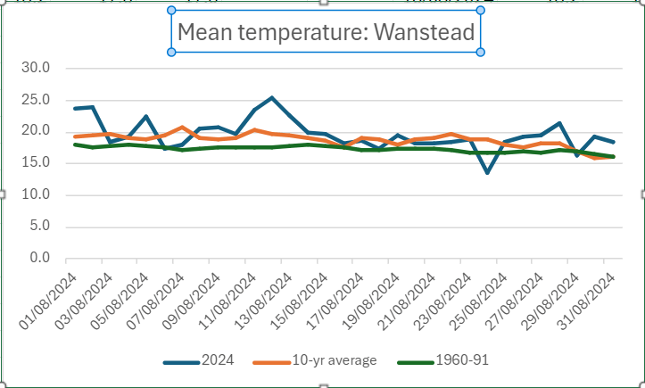
A look at the mean temperature shows how much the climate has warmed since the period 1961-90. Though the mean last month was only 0.9C up on the previous 10 years it was actually 2.3C warmer than 1961-90.

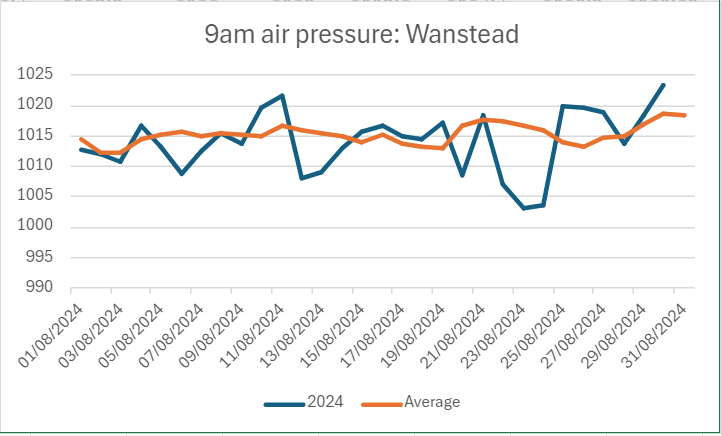
9am air pressure was largely below average with a pronounced dip on 24th bringing notably inclement weather for the time of year.

Here’s a few extremes for the month of September across the capital.