There’s been some very interesting output on the weather models these past couple of days – not least the GFS’s dew points from Christmas Day into Boxing Day.
Very cold air from the east can be seen moving toward the SE of the UK to just across the North Sea – one run has the dew point down to -20C!
The outcome will be different but it’s been a fair while since I’ve seen this sort of solution in what is a relatively short timeframe.
This winter is looking mild or very mild overall with slightly above average rainfall.
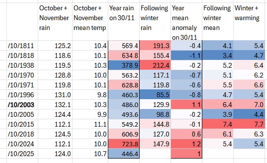
This year I’ve added to my previous method of forecasting by also considering the 12-month rolling rainfall statistics on November 30th together with the January-November mean anomalies.
This gave the following list.
Thus, in terms of chances:
Above average
>6.2
46%
Average mean (C)
5.2-6.2
36%
Below average
<5.2
18%
And for rainfall:
>125%
195
18%
Average (mm)
156.1
64%
<75%
117
18%
The ‘line of best fit’ appears to be the winter of 2003/04 which, after a cold snap in late December that delivered a maximum snow depth of 7cm on December 29th, it turned out to be yet another mild winter.


You must be logged in to post a comment.