Turfed out

Grass roots left for councils to grab,
into darkness is nature plunged.
By acres of green plastic drab, 
of reason, we are now expunged.
But this is what the people want, 
of climate we are nonchalant.

Warnings are for other people,
yet last year floods claimed your garage.
Memories lost, in discharge faecal,
not long before the next barrage.
Clues are in that relentless march 
of CET upwards, landscapes parch.

On we go, no time for nature,
let us now pave over that drive.
Flat Earthers all, blind to danger 
of the abyss, we’re doomed to dive.
Fear not we’ll scrub the atmosphere.
Of carbon dioxide from air near.

Fly away we must on breaks grand,
Worry about climate later.
Holiday firms need that demand, 
from the poles to the equator.
But it’s home, our backyards we need
to restore nature, not concede.

UK rainfall: Seathwaite / Honister v London

It’s been a wet winter so far. Some 177mm has fallen in Wanstead – already 122 per cent more what falls in an average winter.

But the amount pales into comparison with the Lake District. Since December 1st 1360mm has fallen at Honister, a station close to Seathwaite which proudly proclaims itself as ‘England’s wettest place’.

Over a calendar year the area usually sees 5.6 times the amount of rainfall of London. However, this winter the total of 1360mm makes it 7.7 times wetter! A testament to just how persistent the SW’ly airstreams have been this season. And a reminder that the Lake District is the called the Lake District for a reason.

Data from the excellent Starlings Roost Weather.

Wanstead weather in December

Continuing on from last month this blog focuses on the weather recorded at this station over the last 11 years.

A look at the twelfth month shows some interesting trends…

The 9am air pressure readings were not included in previous climate summaries owing to analogue barometers only giving approximate air pressure readings. The advent of AWS has changed that, particularly for independent amateur observers.

A look at the below graphic shows pressure falling through the first half of the month. A sharp rise is then seen before falling again – there’s often storms around the 23rd until the 27th.

Average daily windrun is how much wind there’s been during a 24 hour period. The 23rd comes out as windiest.

Average rainfall shows precipitation building through the month, to peak on the 23rd before a sharp drop off after the 27th.

Average daily maximum temperatures during December show a stuttering first 10 days before a steady rise through the next fortnight before a steady fall off from the 23rd .

Average daily minima is up and down in the first 10 days before a steady rise from the 11th. Again there’s that falling off a cliff on the 23rd.
This pivotal date, being so close to Christmas Day, is one of the reasons why ‘will it, won’t it be a white Christmas’ is a perennial fascination among the nation.

Advertisements

London winter forecast 2023/24

The coming winter is likely to be mild and wet thanks to a predominant south-westerly Atlantic regime.

This year I have tried to improve my statistical method by using historic data from across the capital thanks to the Met Office’s ever expanding library of data; daily Kew values now date back to 1881!

In terms of rainfall and mean temperature a total of eight years were similar to this October and November, spanning 1929 to 2020.

The probabilities for the following DJF winter were thus.

Mean temperatureProbabilityRainfallProbability
Very mild37%Wet37%
Average to mild51%Average63%
Below average12%Dry0%
London winter forecast 2023/24

Looking deeper into the stats I had a look at the Oceanic Niño Index; the most similar years to this one were 1982 and 1987.

A note on WeatherWeb mentions exception rainfall in the Lewes & Brighton area of Sussex, between 20th September and 31st December 1982.

January 1988 was the wettest in England and Wales for over 40 years, and the wettest at Hampstead since records began there in 1909.

February of that winter also saw a major storm affecting much of the British Isles on the 10th and 11th with much damage to buildings.

The prognosis for snow at this point seems bleak – though chances may be heightened should we experience a stratospheric sudden warming in December / January. Though, as seen in 1987 where a vortex ‘split’ was recorded, this would still not guarantee wintry weather.

Taking the above years into account would give a winter where the average mean would follow this graph. Therefore, after the cold snap during the first week of December, the temperature gradually climbs through the month until the 18th when the will be a gradual drop for a possible cold snap between Christmas and New Year.

This then followed by the usual warm up in the new year with changeable weather through January. The best chance of a sustained cold snap appears to be from February 7th to 13th.

Disturbed autumn regimes

October 18th this year heralded a run of weather where it has hardly stopped raining in this part of the south-east.

Since that date there has been 101mm of rain with 22 ‘rain days’, 24 hour periods where there’s been 0.2mm of rain or more. Just one of the last 24 days has been completely dry.

In terms of the 1991-2020 average the amount represents just under twice the usual amount of rainfall at this time of year.

In terms of unusual weather patterns it is up there amongst the ‘top 10’.

What does it mean for the coming winter. Impossible to say on a small scale but I’m guessing wet and mild in the south. Note however that 1960/61 and 1998/99 had a number of maritime northerly outbreaks which added up to an average winter in Scotland, and plenty of snow for the Highlands.

Also note how similar this autumn is to last year when the snowy spell in December came out of nowhere.

The Hampshire tornado of December 1821

While researching an incident of very low pressure in 1821 I also found this account of a tornado that happened a couple of days later – not dissimilar to events earlier this month close to the south coast of England.

In The Climate of London, Luke Howard writes about an account of an ‘electrical whirlwind’ or spout in Hampshire.

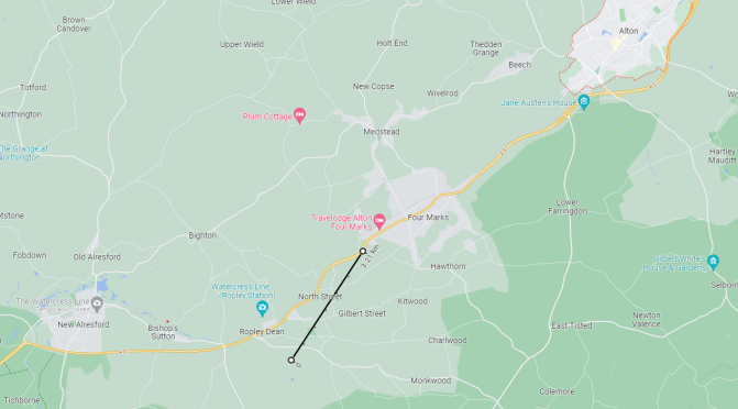
On December 27th, two days after the record low pressure recorded in the London area, residents between the towns of Alresford and Alton witnessed a thunderstorm that was accompanied by torrents of hail, rain and gusty winds at 2.30pm.

A funnel was seen tapering gradually to the ground, the vortex bending from the prevailing SW’ly wind. Lasting for two minutes, according to one account, the whirlwind caused havoc as it carved a ‘serpentine chiefly in the direction of London Road’.

Its effects were restricted to a distance of two miles along a path of varying between 6ft and 20 yards in width.

One person described the tornado as a body of thick white mist tapering from the clouds and near the earth about the size of a woolpack. It appeared to him to touch the earth and bound from it repeatedly. Another witness who was nearer said he felt as if pails of water were thrown on him such was the effect of the strong electric aura attending it though there was no discharge of water at the time from the cloud.

The aftermath revealed a trail of destruction. An oak tree, a ‘foot and a half’ in diameter, was broken and carried upwards of 40 yards. Several fences were removed to a distance of many feet.

In the village of Ropley a farmhouse was damaged two barns were destroyed. Large elm trees were uprooted, a ‘fine walnut tree broken in half’ and gates, stiles and even thick gate posts were torn up.

The trees and ruins blocked the coach road and ‘it required some hours labour to clear them away’.

Looking at the possible track of the tornado it occurred close to the UK’s ‘tornado alley’!

The local problem of global climate change

This year is likely to be the warmest on record globally, statistics from the Copernicus Climate Change Service suggest.

Samantha Burgess, deputy director of the Copernicus Climate Change Service, said: “October 2023 has seen exceptional temperature anomalies, following on from four months of global temperature records being obliterated. We can say with near certainty that 2023 will be the warmest year on record, and is currently 1.43ºC above the preindustrial average.”

On a local scale the average maximum temperature, considering the rolling 12-month average, has actually decreased 0.6ºC compared with last year at this date.

Looking at the last 10 years the past 12 months have been the 3rd warmest. With a building El Nino it could be assumed that next year will see a greater increase in anomaly here but, 2015 suggests, positive ENSO can actually lead to a decrease. As can a La Nina lead to an increase, as shown in 2022.

The climate system of the world is complicated in that it doesn’t warm uniformly which leads to problems when a sizeable part of a population look out of their windows and see weather that is cold and miserable. That social media lists the ever increasing number of weather disasters around the world doesn’t seem to make a difference.

Governments and agencies have their work cut out trying to convince enough people that we really must better look after the world, starting in our own back yards.

As Burgess adds regarding the United Nations Climate Change Conference later this month: “The sense of urgency for ambitious climate action going into COP28 has never been higher.”

YearRolling 12-month maximum at 7/11Change
201416.58
201515.53+1.05
201616.36-0.83
201715.96-0.4
201816.22+0.26
201916.21-0.01
202016.35+0.14
202115.25-1.1
202217.09+1.84
202316.49-0.6

Wanstead weather in November

The current site hosting Wanstead’s weather station has been running for 11 years this month; the automatic station uploading data every 10 minutes to the internet.

The 10-year averages from the station are now good enough to be listed on the Climatological Observers Link.

A look at the eleventh month shows some interesting trends…

The 9am air pressure readings were not included in previous climate summaries owing to analogue barometers only giving approximate air pressure readings. The advent of AWS has changed that, particularly for independent amateur observers.

A look at the below graphic shows pressure lowest around the 4th, the stormiest weather of the month. Storm Ciaran in 2023 is proof of that.

Average daily windrun is how much wind there’s been during a 24 hour period. The 21st comes out as windiest, the date when in the past there has been some notable early snowfalls in the south of the UK.

Average rainfall shows most precipitation in the first two thirds of the month with the biggest fall of rain on the 19th.

Average daily maximum temperatures during November take a general decline but, again, there’s a notable fall away on the 20th.

Average daily minima decline to the 5th (the 6th is the median for the first air frost) before increasing before falling away again after mid month.

Wanstead weather: October 2023

The mean for this October finished 13.1C, 1.3C above average. That’s 15th warmest locally since 1797 and 0.6C down on last year! Notable given the start was nearly 6C above average.

Rainfall finished 96mm, 144% of average. Which sounds a lot. But considering the last 5 years it would be third wettest – such is that October now seems to be a default wet month. Back to 1797 it would place 47th.

Looking at the average 9am pressure things really went south after the 17th.

Looking at London as a whole rainfall at this Wanstead station was closer to the total at St James’s Park than Redbridge Roundabout!

And further afield check out how much wetter the south coast was.

Maps courtesy of Starlings Roost Weather.

Record low pressure of Christmas Day 1821

The lowest pressure recorded in the southern UK happened on February 25th 1989 when the barometer fell to 942.4mb.

I was also reminded this week of another occurrence of extraordinary low pressure in southern England on Christmas Day 1821. Luke Howard’s Climate of London recalls the event in his December summary where, he states, the air pressure fell to 27.83 inches (942.4mb).

This month is remarkable for a depression of the barometer which for London at least or its vicinity is nearly without a precedent on record. The lowest observation here given 27.83 in was obtained at Tottenham from a portable barometer of Sir H Englefield’s construction about 5am on the 25th.

Luke Howard

In what appears to be remarkably similar to what is unfolding with Storm Ciaran Howard added that despite the low pressure the weather on Christmas Day was ‘very fine’, a day that was sandwiched by much rainy weather.

In his entry Howard explains:

We had no storm of wind of any consequence after this great depression which it should be remarked had been coming on for about two weeks. It appears by the papers that a like state of the barometer was extensively observed at the same time on the continent and that very tempestuous weather attended it far to the south of our island.

Luke Howard

Howard also received a letter from Thomas Squire of Epping who wrote.

The fall of the barometer has been as wonderful as the fall of rain. On the 24th at midnight my barometer was 27.76 in. It continued nearly stationary till about six next morning when it was 27.73 in. This was its minimum altitude shortly after it began to rise at 8am.

Thomas Squire

Squire’s readings, taken at Epping (105m), can be adjusted for sea level and compared with the hourly trace for Storm Ciaran. Taking this into account the barometer actually bottomed out at 927.6mb! Plotted against Storm Ciaran the behaviours of the two depressions are remarkably similar.

Howard would go on to discuss his findings with the Royal Society the following month in January. He remarks that the low pressure was notable in that it happened in the same year that notably high pressure was recorded in the February. Just like this year! I recorded 1060.1mb on February 5th.

Though low by southern UK standards there have been many deeper depressions to the north.

Meteorology-based musings about east London and beyond